May 12, 2021 – Warming trend continues through today. Lighter onshore winds and cooling temperatures are expected for late week. Some mountain showers and thunderstorms are possible Friday into the weekend.
Discussion
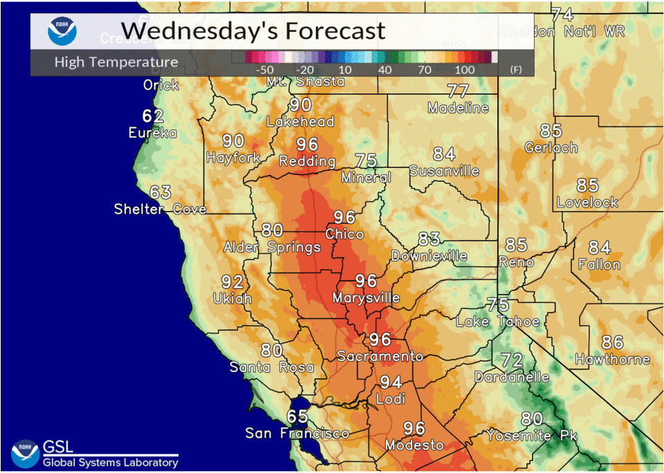
The forecast remains on track this morning as upper level ridging builds overhead. This will lead to another unseasonably hot day with Valley high temperatures reaching the mid 90s, perhaps in the upper 90s for locations in the northern Sac Valley.

The foothills and mountains will be toasty too with highs generally in the 70s and 80s. A Delta breeze looks to develop this evening and then enhance on Thursday as upper level flow becomes more zonal. This increased Delta breeze will help to keep highs a bit cooler in the Delta, southern Sac Valley, and into the northern San Joaquin Thursday.
Temperatures will range from the mid 70s to the mid 80s for the Delta and the upper 80s to the mid 90s for the Valley, while the foothills and mountains vary from the 70s and 80s.

On Friday an upper level trough will be digging down the West Coast and should reach NorCal by late morning into the afternoon. Models continue to show favorable thunderstorm conditions for the Coastal Range and southern Cascades. Guidance has about 100-500 j/kg of CAPE, near 0 LIs, and totals totals between 40 and 50. The forcing from the trough and instability should be enough to kick off an isolated thunderstorm or two. We do see some mid-level moisture build in (PWATS of 0.50″+) but with strong inverted V soundings, any thunderstorms that develop will only produce light amounts of rain and gusty erratic winds will be possible.
The latest deterministic guidance supports nocturnal convection and thunderstorms down towards Lake and the North Bay mountains. Have opted to stick with NBM PoP and kept chances out of those areas, but will keep an eye on this as the event draws near.
By Saturday, the trough should slide south and cause shower and thunderstorm development to favor the Sierra. In addition to renewed mountain precip threat, cooler weather settles in.
Daytime highs generally be in the 80s for much of the Valley, with the exception being in the northern Sacramento Valley where the low 90s are expected. The mountains and foothills will feel the reprieve as well, with highs ranging from the 60s to the low 80s.
Extended discussion (Sunday through Wednesday)
Closed upper low progged to move across SoCal Sunday. Potential for some wrap around showers or thunderstorms over our southern Sierra Nevada Sunday afternoon. Models differ with progression rate of low but by Monday, system appears to be far enough east to no longer poise a convective threat to our forecast area.
High temperatures continue to trend down Sunday into Tuesday, remaining near to slightly above normal, then begin a trend upward again Wednesday.