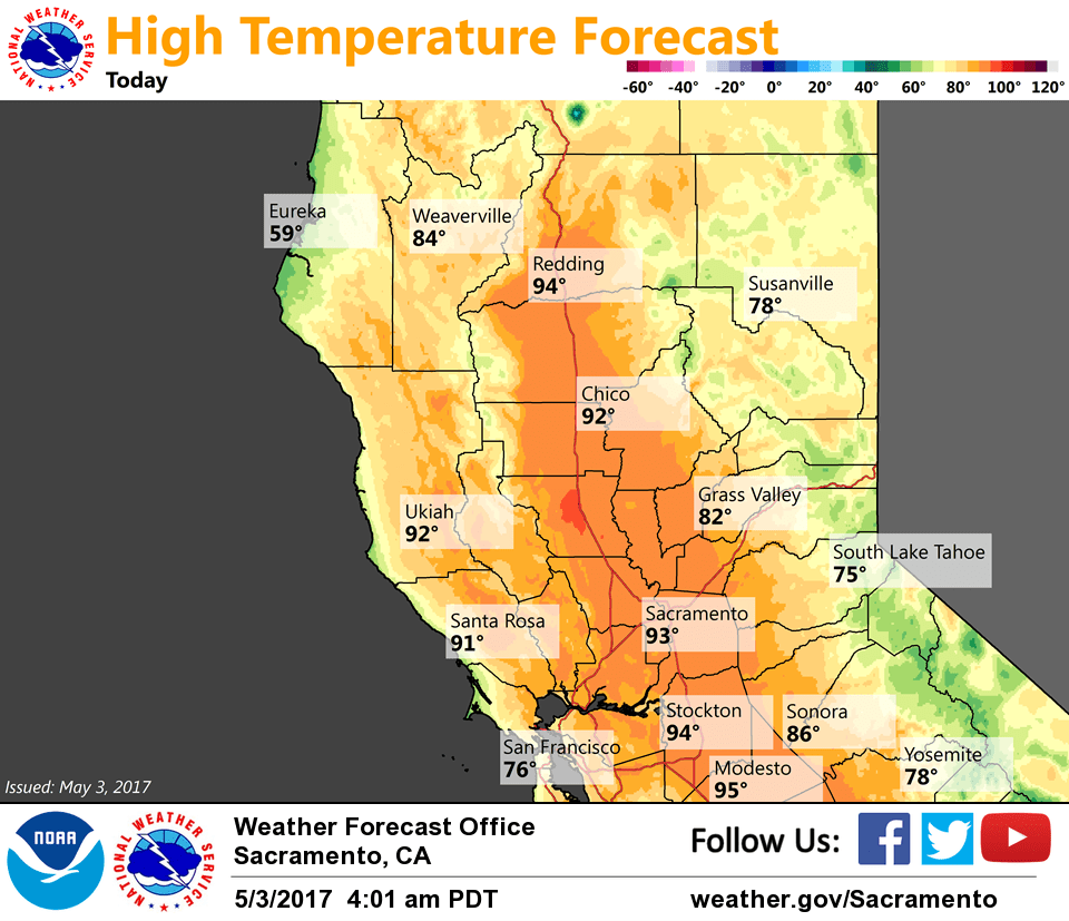
May 3, 2017 – Above normal temperatures continue into Thursday then much cooler Friday into the weekend. Increasing threat of showers and afternoon thunderstorms into the weekend, best chances over the foothills and mountains.
Discussion
Clear skies early this morning with the upper ridge nearing the coast. Temperatures remain very mild with the thermal trough near the coast and light to moderate northerly or offshore flow as surface gradients have tightened a bit compared to 24 hours ago. Current readings are mainly in the 30s and 40s in the colder mountain valleys with 50s and 60s elsewhere. Warmer portions of the valley and foothills are still seeing readings in the 70s.
Today is expected to be the hottest this week with highs throughout the valley expected to top out in the lower to mid 90s, around 15 degrees above average for early May. Breezy northerly winds will continue.
Ridge starts to shift east later today into Thursday. Thursday afternoon will still be rather warm, but should be a few degrees cooler than today in most areas. Remaining moisture and weakening cap may allow for the development of a few showers and thunderstorms across the mountains in the afternoon into the evening.
Significant cool down begins Friday as onshore flow increases ahead of approaching trough. Temperatures will drop 10-15 degrees from Thursday. Another shot of showers and possibly a thunderstorm or two across the northern mountains Friday and Saturday, but confidence is low in coverage. Any accumulations should be light.
Extended discussion (Sunday through Wednesday)
A cooler wetter pattern is expected for the extended period as an upper level low cuts off over the region. The upper low center will move over Central CA and keep shower chances in the forecast. Shower chances stay in the forecast, mainly over the mountains, under the wraparound moisture flow early next week as the system lingers over SoCal.
This upper level system will keep things cooler throughout the period but we do start to see a warming trend starting Monday. The next eastern Pacific trough begins to swing in Wednesday and impact the area with some shower activity and cooling temperatures, but exact timing is still up in the air.