Shower and thunderstorm chances become more extensive through midweek. Temperatures cooling to below average by Tuesday. Isolated to scattered thunderstorms may produce heavy rain, dangerous lightning, gusty winds and hail impacting outdoor activities and recreationists. Heavy rain from stronger storms may lead to localized flooding and increased travel times.

Discussion
Satellite imagery shows clouds continuing to stream into NorCal from the southeast as low pressure approaches the California coast to the southwest of Vandenberg, and radar shows some virga and perhaps a few light showers over the northern Sierra/southern Cascades.
Profiler data indicate the marine layer is deepening along the coast (approaching 1.5k ft at Bodega Bay) and surface pressure gradients are trending back toward stronger onshore flow (winds at Travis AFB are gusting to nearly 30 mph).
Despite this, current temperatures are still very mild and are mainly in the 50s and 60s, except for low to mid 70s over the northern half of the Sacramento Valley. It was a hot day across the region on Sunday with the first triple digit heat of the season recorded at Redding (101) and Red Bluff (100).

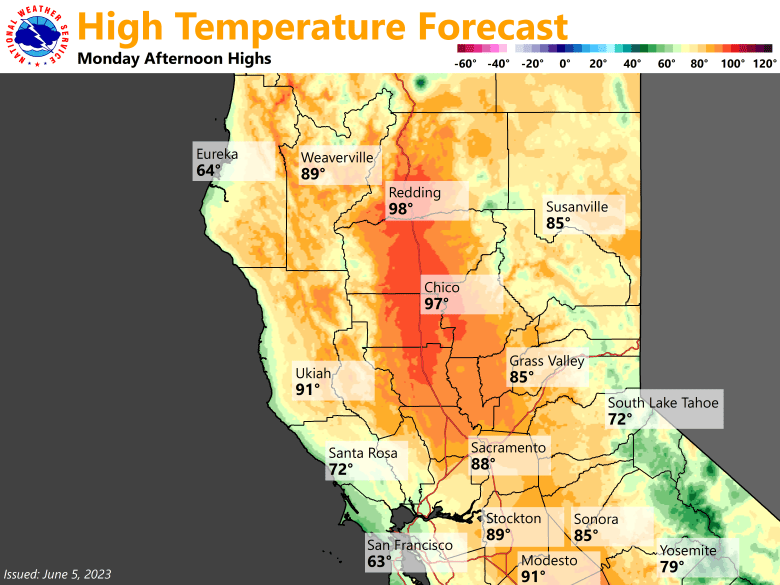
Another hot day is expected across most of the Sacramento Valley and surrounding terrain while areas closer to the Delta will begin to feel the effects of increased onshore flow. Redding will likely see its high fall short of the century mark, but it will still be warm/hot with readings in the mid to upper 90s across the north end of the valley.
Further south, around 5-10 degrees of cooling is expected compared to Sunday for the Fairfield, Sacramento and Stockton areas. The low will be over central/southern California into mid-week continuing to send moisture northward into NorCal.

The result will be an increasing threat for showers and thunderstorms, mainly during the afternoons/evenings, and mostly over higher terrain. Stronger storms will be accompanied by heavy rain and frequent lightning, and increasing bulk shear of 25-35 kts could allow for some larger hail and strong outflow winds, especially Tuesday and Wednesday.
Flow from the east to southeast will also be favorable for steering storms that initiate over higher terrain during the afternoon down into the foothills and portions of the valley during the late afternoons/evenings. With the large amount of elevated moisture and instability, any embedded disturbances in the flow may be enough to also trigger some nocturnal deep convection.
The combination of increased cloud cover, synoptic cooling from weakening high pressure, and increased onshore flow will result in a significant cooling trend for the entire area by Tuesday with high temperatures returning to below normal.
Extended Discussion (Friday through Monday)
Ensembles and clusters indicate some form of trough and/or upper low remaining over Central California late this week and through the weekend. This will keep unsettled weather with daily shower and thunderstorm chances, mainly over the mountains. Temperatures will remain at or below average.
