Isolated mountain thunderstorms along and east of the Sierra Crest this afternoon and evening. Elsewhere, quiet and warm weather continues.

Discussion
Infrared GOES-West imagery shows some leftover high clouds from yesterday’s convection, as well as a few hotspots in Shasta and Siskiyou County associated with the Salt and Lava Fires. Temperatures are generally running within a few degrees from what they were 24 hours ago, and will bottom out by sunrise in the 50s to 60s in/around the Delta, southern Sacramento Valley, and northern San Joaquin Valley, to as mild as the upper 60s to middle 70s in the northern Sacramento Valley and the adjacent thermal belts. Onshore gradient is +3.3 mb from San Francisco to Sacramento with Travis Air Force Base gusting right around 30 kt.

Upper level high over the Desert Southwest will continue to draw moisture north/northwest into portions of the Golden State again this afternoon. This will result in the chance of afternoon showers and thunderstorms, mainly along the Sierra Crest from I-80 and points south. A weak upper level wave will ripple through the clockwise flow aloft, promoting the chance of some overnight convection in parts of the Sierra. The latest 3-km NAM suggests some isolated mid-based convection with the best chances along and east of the crest.
Another slight chance of afternoon/evening thunderstorms will return on the Fourth of July. Similar to Saturday, these chances will largely be confined along/near the Sierra Crest. If you have camping, hiking, or outdoor plans in the mountains over the holiday weekend, always a good idea to keep your eyes on the sky. When thunder roars, go indoors! Chance of mountain showers/thunderstorms becomes very limited on Monday with less than 5 percent probability.
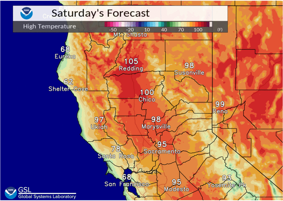
Only minor fluctuations in high are expected through the holiday weekend with max temps in the upper 80s to middle 90s in the Delta through Sacramento Metro, and as hot as the upper 90s to 105 deg F range for the central and northern Sacramento Valley.
Extended Discussion (Wednesday through Saturday)
Upper high over the Desert SW continues to be main synoptic feature influencing weather over interior NorCal through the extended forecast period. This will result in dry conditions with above normal daytime temperatures.
Triple digit highs will persist in the Northern Sacramento Valley, expanding into the central part by the end of the week. Heights continue to rise next weekend resulting in additional heat impacts as high temperatures climb above the century mark throughout much of the Central Valley.