Hot weather will continue this week with triple digit heat persisting across the northern Sacramento Valley and surrounding terrain. Thunderstorm chances return to the northern Sierra through the remainder of the week, mainly along and east of the crest.

Discussion
Some debris cloudiness left over from Monday evening’s thunderstorms over the Sierra lingers early this morning, otherwise skies are clear across interior NorCal. Onshore surface gradient has slackened since Monday, but despite this, a moderately strong Delta Breeze persists. Current temperatures are running a little cooler across much of the region compared to 24 hours ago with the exception of areas influenced by the Delta Breeze which are a little milder.
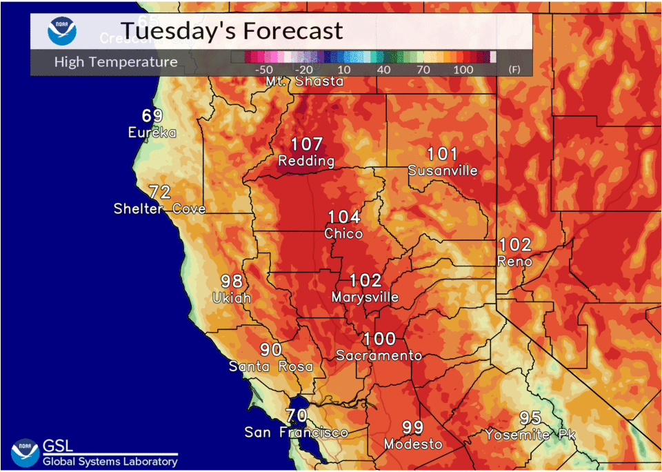
The strong high centered over the PacNW is forecast to nudge a bit to the east today as the tight closed low off the coast moves north. Strong subsidence remains in place and the marine layer has been suppressed below 1k ft. Many areas will see temperatures increase a few degrees compared to Monday, and highs of 105-110 will be possible across the far north end of the Sacramento Valley.

Moisture continues to work its way westward across the Great Basin beneath the high. A few thunderstorms are expected to develop again late today across the northern Sierra, but activity further north will likely remain suppressed by a strong mid-level cap.
Temperatures are forecast to moderate somewhat during the second half of the week as the strong PacNW ridge shifts east. The marine layer will likely deepen again allowing more significant local cooling to return to the Delta and Sacramento/Stockton region. Late-day thunderstorms will also likely spread further north into the southern Cascades, but most activity is expected to be along the periphery of the forecast area.
Extended Discussion (Saturday through Tuesday)
Desert SW upper high modeled to be dominant synoptic feature influencing weather over interior Northern California through extended period. This will result in near to above normal daytime temperatures with triple digit heat persisting in the Northern Sacramento Valley. Mid level flow is favorable to draw increased moisture over the northern Sierra Nevada to eastern Shasta mountains Saturday. This will lead to a threat of afternoon showers or thunderstorms. Thunderstorm threat persists over the Sierra Nevada Sunday afternoon.