Hot streak will continue this week with widespread triple digit high temperatures in the Valley. Monsoon moisture heading north will set off showers and thunderstorms today, including the chance for a few storms over the Central Valley. Thunderstorm chances retreat to the Sierra on Thursday. Red Flag Warning from 11 AM this morning to midnight PDT tonight. Heat Advisory until 8 PM PDT Friday.
Discussion
Satellite shows an extensive area of mid and high clouds moving northwestward into the region ahead of the weak low off the central California coast. Enhancement is beginning to occur to our south along the coast and over the San Joaquin Valley, and some lightning is now showing up along the coast to the south of Monterey.
Temperatures remain very mild early this morning with current readings mainly in the 70s to mid 80s across the Central Valley, around 3-7 degrees warmer compared to 24 hours ago. IR difference imagery shows stratus beginning to move up the coast, but the marine layer remains shallow (around 1k ft deep) with no cooling effect yet into the Delta.

Clouds and elevated instability will continue to spread northward today. The low along the coast may provide enough lift for some high-based storms this morning over the Central Valley (hi-res CAMs indicate best potential south of I-80 early this morning, then spreading north by late morning).
Scattered terrain focused storms will develop this afternoon over the Sierra and portions of the Coast Range. Storms over the northern portion of the forecast area will have the best chance of seeing some dry lightning, and a Red Flag Warning has been posted for the northern Coast Range, eastern Shasta County and the Mt Lassen area into this evening.

Deeper moisture and instability will shift east the next couple of days with thunderstorm chances expected to retreat to the Sierra crest Thursday, and then to areas south of Tahoe on Friday.
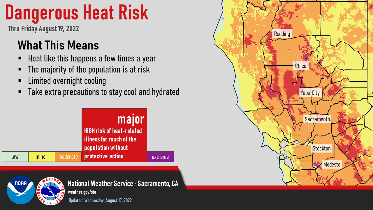
Another hot day is expected across interior NorCal, though the increase in clouds may moderate temperatures a bit compared to Tuesday. Some relief may occur near the Delta on Thursday, but overall hot weather pattern will continue through the end of the week. The Heat Advisory remains in effect until Friday evening.
Extended Discussion (Sunday through Wednesday)
Short wave trough moves into the PacNW, and southern portions of NorCal Sunday into Monday. This will result in increased onshore flow and significant synoptic cooling, with high temperatures returning to near normal. Warming trend Tuesday into Wednesday as ridging begins to increase again over the area. Dry weather expected through the extended period.