July 25, 2017 – Slight chance of afternoon thunderstorms across higher elevations today and Wednesday. Near normal temperatures through Weds, then hot and dry Thursday through the weekend.
Discussion
Very slow moving upper low is currently situated along the northern CA coast. Considerable moisture and elevated instability out ahead of this low has allowed for nocturnal showers and a few thunderstorms to form overnight, mainly along and east of the Sierra Cascade crest. Temperatures across the region are largely cooler than they were yesterday morning, owing largely to a reinvigorated marine layer and synoptic cooling.
The aforementioned low will wobble around the northern CA coast today, but for all intents and purposes will remain nearly stationary. Given this position, convection this afternoon will likely be in similar areas this afternoon as they were yesterday. The focus will likely be along and east of the Sierra Cascade crest. Most of our CWA should remain dry, with the best chance of convection along the mountains near Lassen Park. Temperatures this afternoon will peak in the 90s to around 100 degrees across the Valley, with 70s to 90s over the mountains.
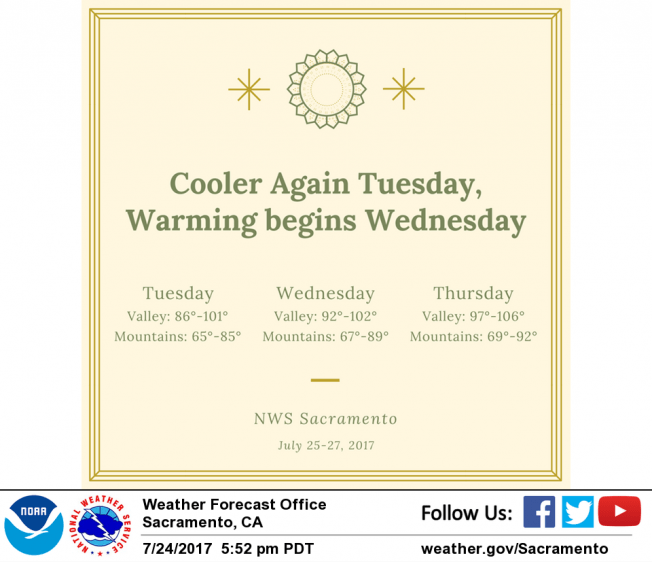
The upper low will slowly drift inland and weaken on Wednesday. Convection should decrease in coverage in response, though the potential for thunderstorms will remain near and northeast of Lassen Park. Expect temperatures to be a bit warmer than today, but still near normal.
The system finally shifts eastward on Thursday, with a shortwave ridge taking its place. Hot and dry weather will quickly return, with triple digit temperatures expected across the Valley Thursday and Friday.
Extended discussion (Saturday through Tuesday)
Temperatures are expected be about 5-10 degrees above normal during the extended period as high pressure over the Four Corners region rebuilds across the area. There is still some model disagreement in terms of the position and strength of this ridge. Regardless, daytime highs will likely reach the century mark across the Sacramento valley.
Monsoonal moisture could be advected northward around the Four Corners ridge early next week. In addition, elevated instability charts suggest isolated thunderstorms could be possible near the Sierra crest Tuesday afternoon. The GFS is the most aggressive solution, but the Euro and the Canadian models keep the forecast area generally dry. For now, have added a slight chance of thunderstorms mainly south of Lake Tahoe given model differences.