September 21, 2017 – Unseasonably cool weather system will bring mountain rain and snow showers into early tonight. Several inches of snow are possible at high elevations. Turning warmer and drier this weekend. Winter weather advisory in effect from 8 am this morning to 11 pm this evening above 7000 feet.
Discussion
A winter like trough will continue dropping south into northern California Today. Disturbance currently over Southern Oregon will swing through the Sierra during mid-morning and exit early tonight. Steepening lapse rates will contribute to increasing instability over the Sierra…especially locations above 5000 feet. Short term meso-scale models(HRRR) support scattered convection this afternoon at higher elevations and have introduced thunderstorms to the forecast.

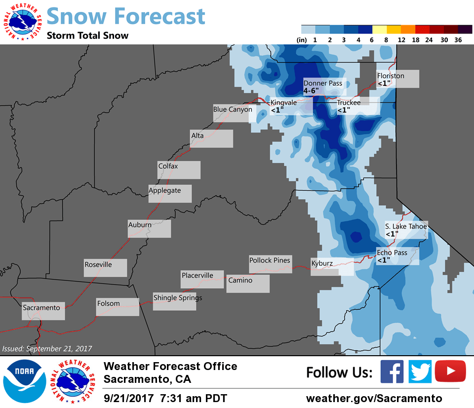
Snow levels presently around 7000 feet along the I 80 and highway 50 corridors will fall to around 6000 feet during the day as cold air advection works south. Moisture is a bit limited…however cold early nature and sufficient instability will act efficiently with available moisture. HRRR/NBM give liquid precip amounts from 0.25-0.75 inches over the Sierra. Snow amounts from 3 to 6 inches with higher amounts over peaks seems likely in this scenario.
Since late September is an unusually early time for this amount of snow have decided to issue a winter weather advisory above 7000 feet with main concern near Donner pass. Convective nature of showers will mean potentially large variability in amounts from place to place.
Trough will shift east into northern Nevada with cut-off low developing. Second disturbance will drop south along the Sierra late Friday with another quick shot of snow above 6500 feet with the focus more south of highway 50. 2 to 4 inches looks possible at this time.
Extended discussion (Monday through Thursday)
High pressure ridging spreads in from the west as the deep upper trough shifts eastward into the Rocky Mountain region by early next week. Confidence is high for a warm and dry pattern over Norcal at least through the first half of next week. Temperatures will be above normal starting on Monday, and trending upward a few degrees more on Tuesday. Valley highs generally in the lower 90s are forecast for Tuesday through Thursday.
Breezy north winds are expected to continue through mid week next week. These winds will act to warm and dry the area, creating an elevated fire risk for the area.