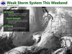
December 2, 2017 – Chances for rain and higher elevation snow today through early Sunday. Valley fog this morning. Return to dry weather next week with breezy north winds Monday.
Discussion
High cloud cover streaming in over NorCal this morning ahead of an upper level Pacific trough. Much of the central valley is seeing fog this morning. Varying cloud cover will continue to bring varying fog density making aviation forecasting tricky this morning. So far, widespread dense fog has not been reported but patchy dense fog will remain possible throughout the morning hours.
The Pacific trough will bring precipitation chances across the north state today with increasing chances this evening. For the most part, models keep the precipitation threat north of the interstate 80 corridor. Snow levels drop relatively low tonight down to between 4000 and 5000 feet or well below pass levels.
Good news is that precipitation amounts are forecast to remain fairly light so no more than a couple inches of snowfall are expected between Saturday and Sunday afternoons. At this point, thunderstorm activity looks unlikely due to lack of instability but an isolated cell may be possible this afternoon or evening.
By Sunday afternoon, Sierra will be on the back side of the trough so any shower activity should be ending. Overall cool airmass and cloud cover will keep daytime highs over the weekend near or a little below season normals.
On Monday, NorCal will be between retreating upper trough and a ridge of high pressure building over the Eastern Pacific. Northerly flow aloft between the two combined with an increasing northerly surface gradient will bring breezy north winds to most areas. Upper ridging pushes in over NorCal on Tuesday bringing warming airmass for above normal highs, lighter winds and continued dry conditions.
Extended discussion (Wednesday through Saturday)
Dry and pleasant weather will continue the middle of next week into the weekend. High pressure along the west coast will keep any weather system from making it to interior Northern California. Expect seasonal to just above normal day time high temperatures Wednesday through Saturday, but overnight lows will be on the cool side thanks to clear skies and calm winds.


