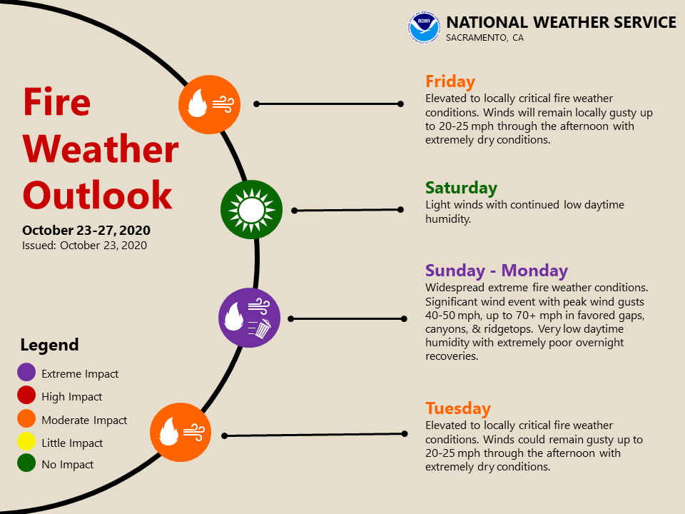
October 23, 2020 – Gusty winds with low humidity and record dry fuels will continue to bring critical fire weather conditions into this afternoon. Cool temperatures expected this weekend as a cold system moves into the Great Basin, with a few light showers in the Sierra south of I-80 Sunday afternoon. This system will bring a very strong north/downslope drying wind event and critical to potentially extreme fire weather conditions across Northern and Central California Sunday into early Tuesday. This looks to be the strongest fire weather event of the year so far with extremely poor humidity recovery and powerful wind gusts over ridges and northeast oriented canyons. We will update the forecast as conditions change.
Discussion
Surface pressure gradients have decreased somewhat, but a moderately strong north and east gradient remains in place across NorCal. Gusts in the teens to lower 20s mph persist across much of the Sacramento Valley, while local gusts of 35-50 mph are occurring across the surrounding foothills. RH`s are currently in the teens and 20s percent across this area continuing the critical fire weather conditions.
Winds will taper this afternoon as pressure gradients finally relax. Highs today will rebound several degrees as the airmass modifies a bit behind the front.
Some RH recovery, along with cooler temperatures, will be possible Saturday as flow briefly reverses to onshore ahead of the next upstream short-wave. There is still some uncertainly on its track, but the northern Sierra south of I-80 may see a few light showers on Sunday as it approaches.

The more significant impacts from this system will be the potential for an extreme northeast wind event beginning Sunday night as upper flow comes into better alignment with a tightening easterly surface pressure gradient. Winds will increase through the day Sunday, becoming strong Sunday night.
A Fire Weather Watch is in effect from late Sunday morning through Tuesday morning.
Extended discussion (Tuesday through Friday)
The upper level trough that will bring strong winds to NorCal early in the week will be closed off over the Desert SW for the start of the extended period with upper level ridging building in.
This will bring much quieter weather along with less wind. Daytime humidity does look to remain very dry though with daytime humidity in the teens. Overnight recoveries will be better than earlier in the week but will still be poor to moderate in the foothills.
Late in the week a trough will dig out of the Gulf of Alaska and push into BC. This will have little impact on our weather but will flatten the ridge some and maybe bring some high clouds to northern areas.
High temperature for the period will warm back above normal but overnight lows will remain on the chilly side.