Seasonably cool temperatures are forecast again this afternoon with periods of breezy onshore winds. Temperatures will warm to above normal levels by late week. Winds shift to the north Thursday becoming locally breezy Friday and Saturday. Smoke and haze from wildfires will continue to impact portions of interior Northern California.
Discussion
GOES-West infrared imagery reveals some scattered high clouds across far northern California on this early Wednesday morning. Aside that, clear skies prevail overhead. Satellite imagery also shows the area wildfires continuing to burn hot well into the nighttime hours, particularly portions of the Caldor and Dixie Fires. The marine layer is well-established along the coast, approximately 1800 ft deep or so with the onshore surface pressure gradient between San Francisco and Sacramento at +2.1 mb, both of which are relatively close to what they were 24 hours ago. By sunrise, expect Valley temperatures to bottom out in the 50s to middle 60s with some isolated rural locations possibly falling to the upper 40s. For comparison, normal low temperature for August 25 at Downtown Sacramento is 58 deg F and 62 deg F at Redding.
Offshore trough will push inland over the course of the day, leading to some locally breezy southwest/west winds, particularly around the Delta, foothills, and mountains. As the trough progresses east into the Great Basin, winds are forecast to switch and become offshore — or out of the north/east — on Thursday and persist into the weekend. Strongest winds are forecast to occur on Friday where the offshore wind-prone locations (e.g., Shasta County, favored locations along the west side of the Sacramento Valley, Jarbo Gap, and other favored Sierra canyons/gaps) could see north/east wind gusts in the 20 to 30 mph range, possibly a bit higher according to the 3-km NAM. These winds will be accompanied by lowering afternoon relative humidity values, and combined will result in elevated fire weather concerns.

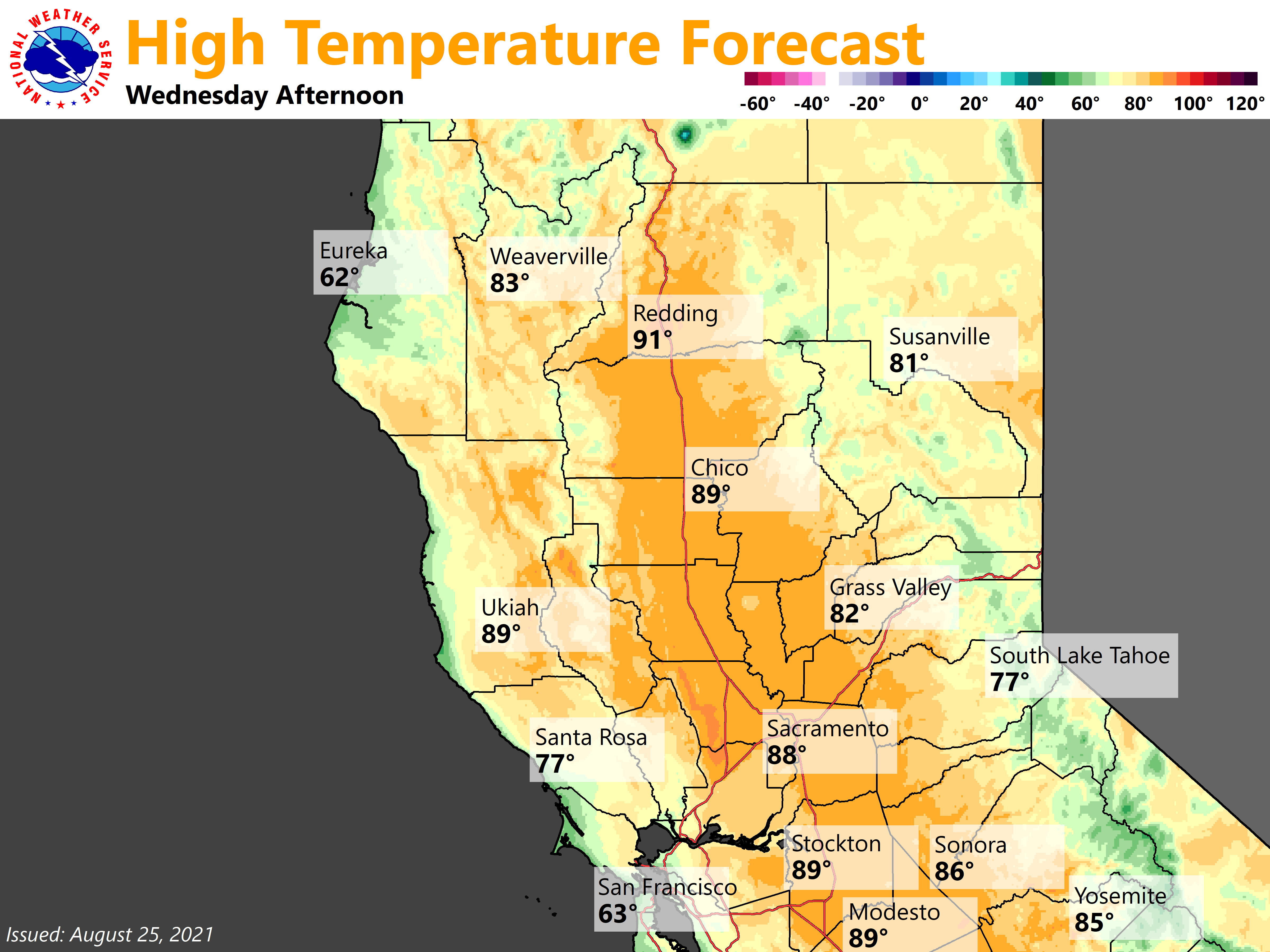
Behind the trough, upper level ridge in the Pacific around 39N / 140W will expand east toward the Golden State through the end of the week, resulting in day-to-day warming through Saturday. Expect temperatures to be near normal by Thursday, then become above normal by Friday and Saturday with triple digit heat increasingly more likely, possibly becoming Valley-wide on Saturday. National Blend of Models gives Redding a 81% chance of exceeding 100 deg F on Saturday, and 73% for Downtown Sacramento. Wildfire smoke will be the main wildcard on any of these days as any smoke coverage will have the ability to limit full-heating potential. Widespread moderate heat risk is anticipated with the Friday and Saturday heat.

Extended Discussion (Sunday through Wednesday)
Cluster analyses of the ensembles in the extended forecast suggest that the Pacific ridge will gradually weaken from Sunday onward, and lead to decreasing 500 mb heights over northern California. While clusters disagree with the strength and timing, virtually all advertise an upper level wave dropping south from the Gulf of Alaska toward the Pacific Northwest from Monday to Wednesday. This will help gradually moderate temperatures early next week, approaching near normal levels by the middle of the week.