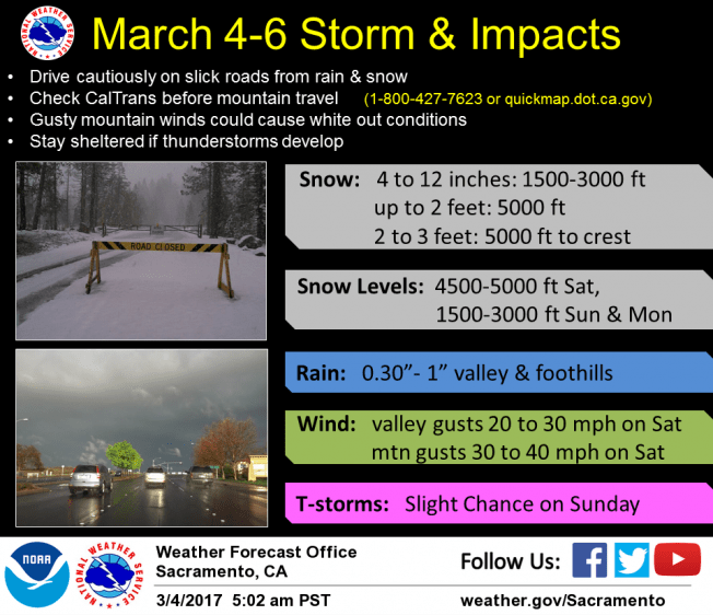
March 4, 2017 – Cooler, unsettled weather this weekend into Monday with low snow levels and significant snowfall. Drier weather returns mid-week.
Wind Advisory until 1 AM PST Sunday for Central Sacramento Valley-Northeast Foothills/Sacramento Valley-Northern Sacramento Valley.
Winter Storm Warning until 4 PM PST Monday for Burney Basin / Eastern Shasta County-Mountains Southwestern Shasta County to Northern Lake County-Northeast Foothills/Sacramento Valley- Shasta Lake Area / Northern Shasta County-Western Plumas County/Lassen Park.
Short Term Discussion (Today through Tuesday)
Latest water vapor imagery and model analysis showed a positively tilted trough moving into northern California, which was bringing the development of precipitation. A surface convergence line located in Shasta/Tehama counties had showers and thunderstorms developing. Some stronger storms along the boundary were producing small hail and gusty winds, along with heavy rain.

Tightening surface pressure gradient will bring increased potential for gusty winds, along with the potential for the lower level jet to mix to the surface this evening. Atmospheric dynamics could allow for showers and thunderstorm to continue for the northern Sacramento valley through the evening hours tonight. Snow will continue for the Sierra with lowering snow levels into the foothills for Sunday.
Chances for showers, thunderstorms, and mountain/foothill snow will continue Sunday into Sunday night. Stormy weather will taper off Monday into Monday night as a shortwave ridge builds into northern California. Dry weather will return for most of the area Tuesday, but some slight chances for precipitation for the northern valley remains as a shortwave trough pushes through the Pacific northwest.
Extended discussion (Wednesday through Saturday)
Flat ridging should bring mainly dry and mild weather across the area Wednesday into Thursday, except for a slight chance of rain for northwestern Shasta County. A relatively weak system will bring the potential for some precipitation over the northern mountains and northern Sacramento Valley Thursday night into Friday. This could spread into the Sierra Friday night into Saturday. Rainfall and snow amounts look relatively modest at this point.