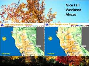
October 4, 2019 – Below normal temperatures today then near normal Saturday. Breezy north winds both days. Warmer than normal early next week then returning back to normal by the middle of next week. No precipitation expected through the extended period.
Discussion
An upper level trough over the Pacific Northwest is bringing some light showers to the northeast corner of the state this morning. With the trough axis now over this area, this shower activity has remained east of the CWA and should continue eastward as the axis progresses east.
With cool air advection into the region, daytime highs will likely remain a little below normal today. Surface high pressure building in behind the trough axis today will bring breezy north winds to much of the forecast area. High pressure begins pushing in over the west coast on Saturday bringing warming with daytime highs bumping up to right around normal as breezy north winds continue.
RH will be on the decline Saturday but fuel moistures should be high enough over NorCal to mitigate significant fire concerns.
High pressure ridge axis centers over the west coast on Sunday bringing more warming with daytime highs forecast at a few degrees above normal. Winds should be a little lighter under the ridge.
Daytime highs level off on Monday as a weak closed low moves on to the central coast. This low may bring some cloud cover the the central region of the state but precipitation is not expected.
Extended Discussion (Tuesday through Friday)
Models similar in digging short wave troughing into the Great Basin Tuesday into Wednesday, progressing it Thursday. EPAC upper ridging remains off the West Coast through midweek, then weakens slightly as it builds inland Thursday into Friday. Dry weather is expected with periods of breezy north to east wind. Near to slightly below normal temperatures are expected through the extended forecast period.

