August 29, 2017 – Not quite as hot today and Wednesday, then very hot weather returns with record highs possible later in the week and through the Labor Day Holiday weekend. Slight chance of late-day thunderstorms over the Sierra Nevada south of Lake Tahoe through Wednesday.
Discussion
Clear skies across the region early this morning with the higher clouds streaming up from the south remaining mainly to our east. The overall offshore gradients have relaxed a bit since Monday and the SFO- SAC gradient has increased along with a deepening marine layer (up to 1500 ft at Ft Ord) resulting in the return of a modest Delta Breeze (gusts 20-30 mph at Travis AFB). Temperatures are a little cooler in the Delta Breeze influenced areas compared to 24 hours ago, and a little milder elsewhere. Current temperatures range from the mid 40s in the mountain valleys to the mid 70s and lower 80s across milder portions of the Central Valley.
A weak trof will temporarily weaken the ridging over NorCal today and Wednesday resulting in a “smidgen” of cooling across the area. The Delta Breeze will also lend a bit more cooling to portions of the southern Sacramento and northern San Joaquin Valleys.
High-level moisture and instability will continue to skirt the southeast corner of the forecast area where a slight chance of late-day thunderstorms will be possible along the Sierra crest in Alpine and Tuolumne counties today and Wednesday.
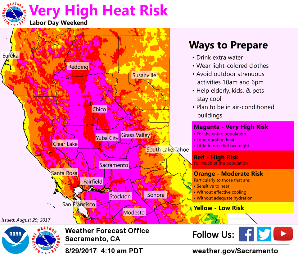
Another extended period of record heat is forecast to commence later this week as strong high pressure from the eastern Pacific moves over the area. Widespread 110-115 max temps possible by Friday in the valley with light northerly flow and 850 mb temps climbing to around 30-32C. An excessive heat watch has been issued.
Extended discussion (Saturday through Tuesday)
Heat continues in earnest for the holiday weekend as strong ridging remains entrenched across the West Coast. Ensemble guidance shows max percentiles for heights and temperatures which should lead to daytime highs 15 to 20 degrees above normal with some daily records likely falling. Overnight lows will remain rather warm as well with limited relief from the heat overnight. Have bumped up temperatures a few degrees from previous forecast in line with model trends. Excessive Heat Watch has been issued through Monday. Outdoor events for Labor Day Weekend will be impacted with a high risk for heat-related illnesses for much of the population, not just sensitive groups. Guidance shows ridge persisting for the foreseeable future with heat continuing into at least the middle next week, though perhaps not quite as hot as the weekend.
GFS shows some moisture surging northward under the ridge with a chance for mountains showers and thunderstorms by Sunday afternoon and Monday while ECMWF suppresses moisture further south. Not sure how widespread activity will be with such strong ridging in place, but have low chances for thunderstorms along the Sierra crest for Sunday, Monday, and Tuesday afternoons. This would increase concerns for fire starts with any activity given very hot temperatures and dry fuels.