February 8, 2017 – Moderate to heavy precipitation with areas of breezy to windy conditions will continue this week as a series of Pacific storms affect the region. Flooding concerns will continue. Drier weather returns for the weekend.
Discussion
Warm front is lifting northward this evening and for the most part only the upslope areas in the mountains are receiving any rain this evening. Snow levels remain high through Thursday and will lower Thursday night. There is still some uncertainty as to when the snow levels will lower below major Trans-Sierra pass levels. It could be early in the evening or close to midnight depending on the model. I have pushed back the timing of the warning to 6 PM for the start of the warning as a result.
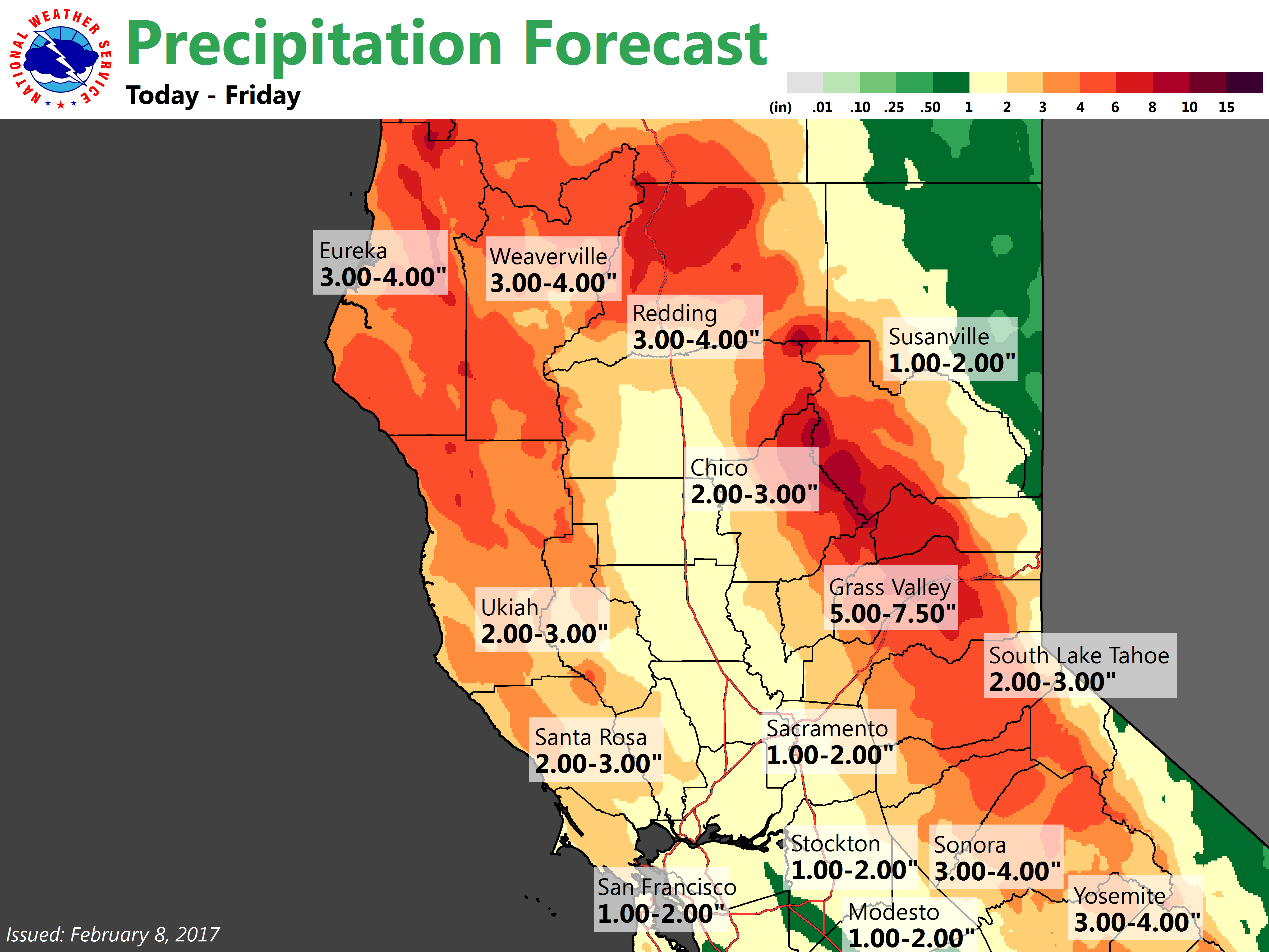
Water wise, rain associated with the front will first move over the north end of the valley in the morning and spread south during the late morning and early afternoon hours. The heavier rains appear to be focused over the Southern half of the Sacramento valley. During the passage of the front expect small river and stream levels to be on the rise and a number of them eventually overflowing their banks. Best estimates for some of the creeks over the north end of the valley to start over flowing their banks would be in the early afternoon while further south it would be in the late afternoon and evening hours. Mud/rock slides for the foothills and mountains should continue during the day with rising river/creek levels and flooding problems occurring at anytime during the day especially over the north, but Thursday evening is when most problems would likely occur. An additional 1-2 inches of rainfall for the valley looks good and 3-6 for the foothills and mountains with some higher amounts for some of the favored south to southwest facing slopes likely.
Winds will continue over the north into Thursday afternoon and will pick up in the southern CWA Thursday morning. Models are mixed on the strength of the winds further south. GFS says advisory level, NAM guidance says no. Current advisory still looks good for now.
Previous Discussion
Forecast concerns will be strong southerly winds across the valley and higher terrain, heavy rainfall, and winter weather for the Sierra.
Incoming upper level trough ahead of moist atmosphere will continue to create heavy rainfall through Friday. Stronger lower level jet and surface pressure gradient will drive increased wind speeds starting tonight through Thursday. Expecting wind gusts up to 50 mph for the valley and greater than 60 mph for mountain peaks in the Sierra.
Snow levels start high tonight through Thursday but will begin to fall to below pass level Thursday night through Friday. Rain will transition to heavy snow during this time frame for Sierra locations along Donner pass and southward. Heavy snow in combination with high winds will create hazardous travel conditions, especially Thursday afternoon.
Showery post-frontal precip is expected Friday with the potential for thunderstorms in the Central Valley if ingredients come together, then drier weather expected to finally return Friday night into the weekend.
Extended discussion (Sunday through Wednesday)
Dry weather is expected under building high pressure for the weekend. The only exception is a few lingering morning mountain snow showers south of South Lake Tahoe. A brief period of breezy north winds will be possible through the weekend, mainly along the western Sacramento Valley and along favored Sierra canyons. High pressure should continue to bring dry and mild weather, with some morning Valley fog possible through the middle of next week. The dry and warm weather is not expected to last long, though. Extended models have been consistently showing a return to wet weather Thursday and Friday.