October 16, 2016 – Periods of rain – heavy at times – gusty winds, and high mountain snow into Monday. Drier weather expected the rest of the week with warming temperatures.
Wind Advisory from 2 PM this afternoon to 8 PM PDT this evening for Burney Basin / Eastern Shasta County-Central Sacramento Valley-Northeast Foothills/Sacramento Valley-Northern Sacramento Valley-Southern Sacramento Valley-Western Plumas County/Lassen Park.
Winter Weather Advisory from 5 PM this afternoon to 11 AM PDT Monday for West Slope Northern Sierra Nevada.
Discussion
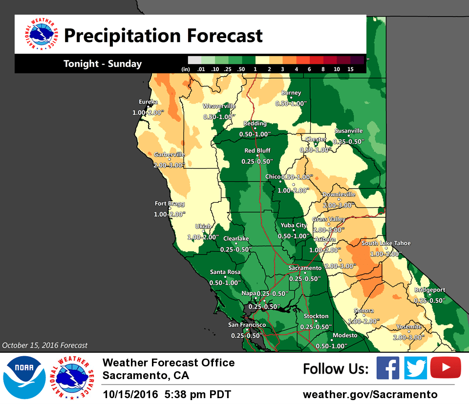
Area of light showers this morning on 88D over the southern half of the CWA with additional waves offshore poised to move inland. Precip expected to increase this afternoon and into tonight as LFQ of 150+ kt jet enters Interior NorCal. Associated strong upper level divergence will result in large scale UVM over the Coastal and Shasta mountains where a period of moderate to heavy precipitation is possible. Favorable orographic flow will enhance precip over the mountains of Western Plumas and Sierra Nevada. Will need to monitor precipitation this afternoon into tonight over the American, King, and Rim burn scars areas. NAM12 CAPE looks less than previous runs for this afternoon with main area of instability depicted over the North and Central Sacramento Valley and along the eastern foothills/mountains. Bufkit 0-6KM shear profiles continue to look quite impressive but the 0-1KM shear is weaker than in previous runs. Isolated rotating storms still could develop this afternoon.
Wind speeds expected to increase today as pressure gradients tighten with strongest wind expected around 00z Mon. Brief period of advisory wind speeds are possible mainly in the Northern and Central Sacramento Valley. May need adjust areas of current advisory with afternoon package.
Snow levels presently around 7000 feet in the Shasta mountains to above 8000 feet over the Sierra Nevada. Snow expected to remain above pass levels today but gradually lower to 6000 feet in the north to near 6500 feet over trans-Sierra passes. Light snow accumulations are possible at Donner Pass on I80 and Echo Summit on Highway 50 tonight into Monday. Lassen Park and higher elevations passes such as Carson Pass, Ebbetts Pass and Sonora Pass could see more significant amounts of snow impacting travel tonight. Winter Weather Advisory for early season snow has been issued to address this.
GEFS/GFS showing integrated water vapor transport decreasing over Interior NorCal Monday with models indicating main threat of light showers confined to the foothills and mountains and possibly Northern Sacramento Valley. Heights increase offshore Tuesday and build inland through midweek resulting in drier weather with warming temperatures.
Extended discussion (Thursday through Sunday)
Upper level high pressure will bring fair skies and near normal temperatures Thursday and Friday. A couple of weak weather systems passing through the Pacific Northwest next weekend will flatten the west coast ridge. This will bring a transition from light northerly flow to light onshore flow. This onshore flow and a slight airmass cooling will bring a cooling trend next weekend. Conditions will remain dry through the extended period however with just some high clouds next weekend.