February 11, 2021 – A weather system will bring widespread precipitation and cooler weather today through tomorrow with another weather system following on Saturday. Mountain travel impacts are expected. Unsettled weather continues through early next week.
Discussion
Early morning satellite imagery shows upper level clouds streaming into interior Northern California as the next weather system approaches the West Coast. Widespread precipitation is on track to move through NorCal today through early tomorrow morning. Latest guidance shows precipitation moving into the north by mid to late morning, spreading southeast through the CWA through the afternoon.
The heaviest precipitation is expected in the late afternoon through evening hours along the cold front, though rain rates are generally expected to remain below 0.5 inch per hour. HREF does indicate a slight chance of a few areas reaching 0.5 inch per hour tomorrow evening, but it shows no chance of rain rates above 1 inch per hour meaning no threat to recent burn areas is expected.
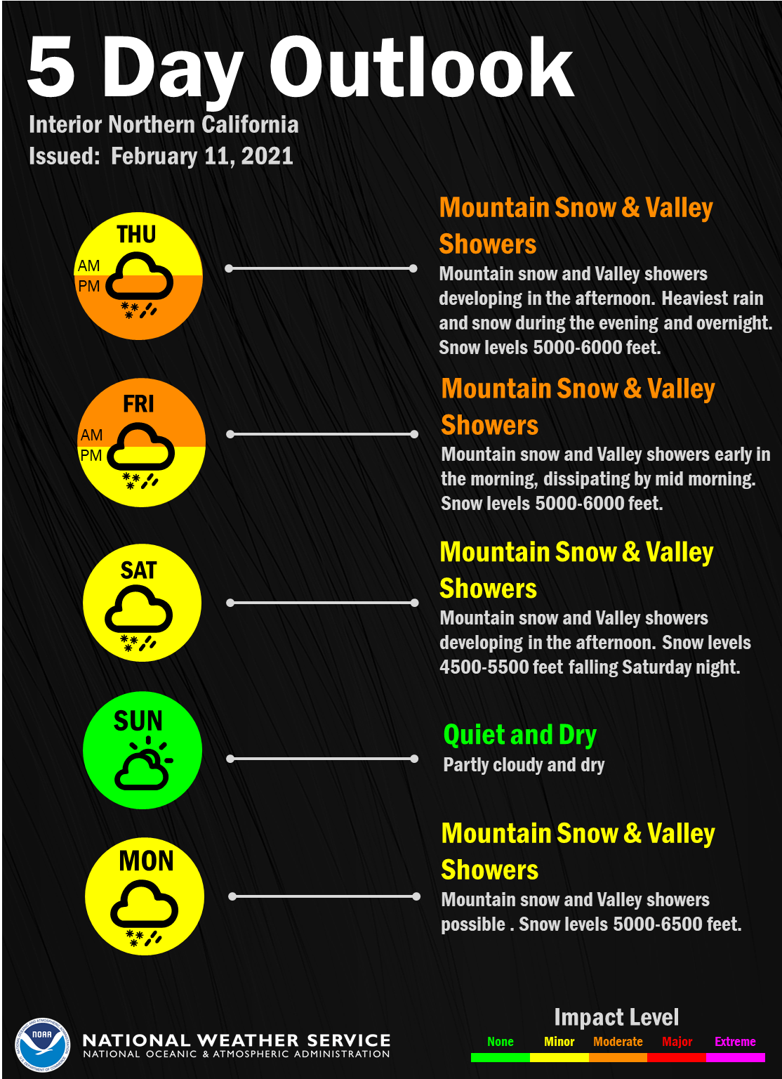
Precipitation is expected to move out of the forecast area by early Friday morning, though a few isolated mountain showers could linger in the morning hours for areas south of I-80. QPF hasn’t changed much with 0.30 to 0.75 inch of rain expected in the Valley and up to 0.75 to 2 inches in the foothills. Snow levels with this system will be 5000 to 6000 feet with the majority of the snow falling above 6000 feet. Around 6 to 12 inches are forecast at pass level with localized amounts up to 18 inches south of I-80. Mountain travel impacts are likely, especially in the late afternoon through evening hours. A Winter Weather Advisory remains in effect from noon today through 4 am Friday.

This weather system will also bring cooler temperatures today. Daytime temperatures will be around 10 to 15 degrees cooler for most locations today than yesterday with Valley highs in the mid to upper 50s. Shortwave ridging is then slated to take over Friday as the upper trough moves southeast into the Desert SW. Temperatures will increase back to near 60 across the Valley which is right around normal for mid February.

Ensemble guidance continues to bring in the next weather system Saturday. Overall this system remains drier than today’s system, though model QPF spread remains fairly wide due to differences in the strength of the system between ensembles.
Current forecast is only a few hundredths up to 0.3 inches of Valley rain with up to 0.75 inches in the foothills. Around 4 to 8 inches of snow is forecast above 5000 feet, with a light about possible down to 4500 feet as the snow levels drop Saturday afternoon. The majority of snow will fall during the day Saturday which will likely cause travel impacts over the mountains, especially since it’s a weekend.
The trough will move out of the area by Sunday morning, bringing another brief break in precipitation. Temperatures Saturday and Sunday will remain similar to Friday.
Extended discussion (Monday through Thursday)
Another system overspreads interior NorCal on Monday, with some lingering mountain showers possible into Tuesday. Weak forcing with this system will limit QPF despite a wide swath of deep moisture impinging on the area.
Behind that, ridging expected to result in dry and milder weather through the middle of next week ahead of another system potentially lurking for the end of the week.