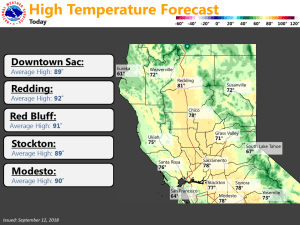
September 12, 2018 – Below average temperatures expected for the remainder of the week. Locally gusty winds over higher elevations through Wednesday. Areas of smoke and haze from wildfires will continue.
Red Flag Warning until 11 PM PDT this evening.
Discussion
Long wave troughing will continue across NorCal for the short term period. This will continue to bring below normal temperatures with the coolest day expected on Thursday. Highs today will run 10-15 degrees cooler then yesterday and 10-15 below normal for this time of year.
Similar highs are expected on Thursday but will be a few degrees cooler. The trough axis will push over NorCal during the evening pushing some upper level energy over the northern part of the CWA. This will bring an isolated shower chance to northern Shasta County for the evening. The better rain chances will remain to our north though where there is more moisture.
We will also see increasing clouds during the afternoon as the trough axis approaches. Partly to mostly cloudy skies are expected for the evening with decreasing clouds overnight. Breezy winds will continue to be an issue today as we see a strong 30-45 knot 700 mb jet over the southern part of the CWA.
The strongest winds will be limited to the Sierra where widespread gusts 30-40 mph are expected with gusts 50 mph plus on the higher peaks. This will continue to bring elevated fire weather conditions to the Sierra but we should see relative humidity levels a bit higher then yesterday. A Red Flag Warning remains in effect for the Sierra through the evening.
Conditions will be a bit quieter on Friday and Saturday as flow becomes more southerly and the 700 mb jet decreases. Highs will be a few degrees warmer but still run well below average. Another vort max passes through Saturday afternoon but with a lack of moisture it will have little effect on us. Overnight lows will be chilly with some patchy frost possible in the higher elevation valleys. Lows will be in the 40s and 50s in the Sac and San Joaquin Valley.
Extended Discussion (Sunday through Wednesday)
Weak Upper troughing along the west coast will keep daytime temperatures a few to several degrees below normal through the extended period. The trough may also bring breezy afternoon winds at times over the Sierra. Even though daytime temperatures will remain below season normals, Sunday will start a slow warming trend as high pressure over the central U.S. pushes back west a bit bringing a slowly warming airmass.
At least a couple of shortwave disturbances are forecast to move into the Pacific Northwest during the extended period. At this time it appears any precipitation should remain north of the forecast area.


