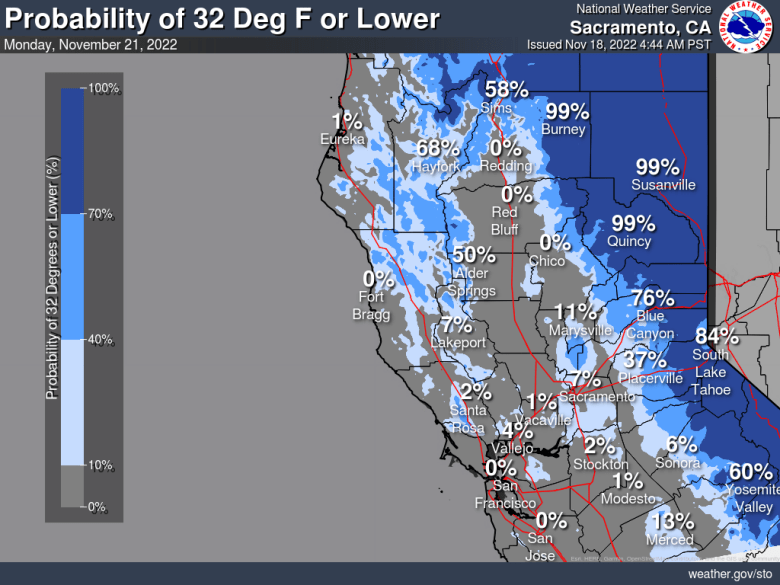
Dry weather with continued cool nights through the weekend. Another round of breezy north to east winds through Saturday. Rain chances will be limited to areas near the Oregon border on Tuesday and again at the end of next week. Cold overnight temperatures continue; possible freeze for rural areas on Sunday-Monday.

Discussion
Satellite imagery shows a band of mid and high clouds moving south across NorCal early this morning. These clouds are ahead of the trough dropping south from the PacNW toward the Great Basin. Northeast surface pressure gradient has weakened considerably compared early Thursday, but enough lingers for some local gusts of 15-30 mph over the northern Sierra and tightening northerly gradient has resulted in a few gusts of 15-25 mph already across the foothills of the northern Sacramento Valley.
Current temperatures are pretty similar to 24 hours ago and mostly range from the mid 30s to mid 40s across the Central Valley. Offshore winds will increase again this morning as the trough/short-wave moves south, surface gradient tightens and subsidence increases in its wake. The tail end of the trough is tracking a bit further to the west, and it’s looking like portions of the Sacramento Valley will see wind gusts around 40 mph, mainly from late-morning through the afternoon. A Wind Advisory has been posted for this area.

It’s still looking like the strongest northeast winds in the foothills and northern Sierra will occur late today and overnight tonight into early Saturday when gusts to 70 mph or higher will be possible in wind-prone areas, and a Wind Advisory remains in effect.
Winds behind to subside in the mountains/foothills on Saturday as a ridge builds back over the West Coast. Dry airmass and clear skies will result in cooler overnight temperatures Saturday night and Sunday morning, and again Sunday night and Monday morning.
May wake up to areas near and possibly below freezing for rural areas of the Sacramento and northern San Joaquin Valleys.

Extended Discussion (Tuesday through Friday)
NBM has trended drier Tuesday which looks good given deterministic models showing similar solutions with weak wave. EPAC upper ridge then builds and moves inland Wednesday into Thursday, shifting into the Intermountain West Friday. This will result in continued dry conditions with above normal high temperatures beyond Tuesday.

