Happening Now is a feature designed to bring updates, announcements and info on news items throughout the day. You are invited to participate. See a road closure? A business opening? A smoke plume? Storm-related mishaps like downed trees, power lines, road or other flooding? Email us at news@yubanet.com or call 530-478-9600 to let us know. You can also text us reports at 530-409-9888, but please don’t text or call while driving. Thanks!
December 31, 2016 at 9:59 PM We’ve received a number of messages regarding fireworks. At this time of year, “safe and sane” fireworks are allowed in the Foothills, with the exception of cities that have banned the use of fireworks.
December 31, 2016 at 9:13 PM Please make sure your pets are safe, fireworks scare most animals.
December 31, 2016 at 7:44 PM Fireworks on Greenhorn Road outside of Nevada City already.
December 31, 2016 at 11:14 AM Car down the embankment on Norlene Way in Alta Sierra. Emergency services en route.
December 30, 2016 at 8:24 AM Smoke check in the area of Slate Creek Road in Grass Valley. Smoke only, no flames visible in the area.
December 30, 2016 at 7:50 AM Chance of showers on New Year’s Eve, low snow levels by Monday. A weak, quick-hitting system will bring hit or miss showers during the day Saturday with a few inches of snow possible down to 4000-5000 feet. A brief break in the weather is expected for New Year’s Eve into early Sunday. Arctic air will arrive next week, which will push snow levels down into the foothills, possibly even into the higher elevations of the Valley, on Monday and Tuesday. Forecast confidence continues to be low on just how low the snow will accumulate but significant accumulations likely above ~4000 feet with travel delays and chain controls.
December 29, 2016 at 8:37 AM Non-injury accident on Hwy 49 near the South Yuba bridge. Use caution in the area.
December 29, 2016 at 8:22 AM Another dry and sunny day across the area. Dry weather will continue through Friday with cool overnight temperatures and patchy morning fog in the Valley. A weak system will bring a chance for showers on Saturday with light snow accumulations in the mountains. Colder systems for next week with snow levels possibly dropping down into the foothills and northern Sac Valley.
December 28, 2016 at 9:29 AM The latest update on the fire at Homewood Ski resort is now posted, thanks to North Tahoe Fire Protection District.
December 28, 2016 at 8:40 AM Dry and cool, chance of showers by the weekend. Cold air from western Canada is likely to push into Northern California early next week. Confidence is low in the details, but this weather system could bring a bit of very low elevation snow! Stay tuned to the forecast as we get a better idea of what this system will bring!
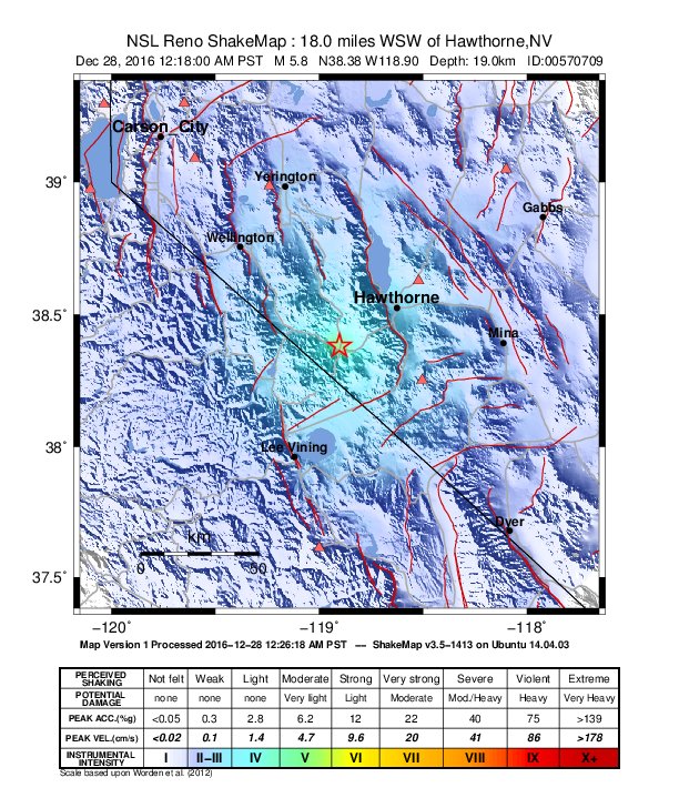
December 28, 2016 at 1:32 AM Third large quake now given as a Magnitude 5.6 quake.
December 28, 2016 at 1:17 AM Another stronger shaking felt in Nevada City, recorded as a 3.1 magnitude. As of 1:17 am, 13 earthquakes in the Hawthorne area. Per Cal OES: Three large #earthquakes (5.7-5.9) near Mono County/Nevada line, no serious damages or injuries reported at this time. Continuing to assess.
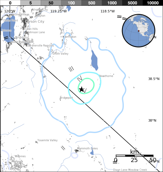
December 28, 2016 at 12:56 AM The first quake has been downgraded to a 5.7 magnitude. The event has been reviewed by seismologists.
December 28, 2016 at 12:43 AM Magnitude 3.6 aftershock in the same vicinity.There are no immediate damage reports from the area.
If you felt the earthquakes, report it to USGS: http://earthquake.usgs.gov/earthquakes/eventpage/nn00570709#tellus
December 28, 2016 at 12:36 AM GDACS also reports reports 2 earthquakes:
Earthquake Magnitude 5.7M, Depth:0km
28 Dec 2016 08:22:12 UTC
About 31162 people within 100km
Earthquake Magnitude 5.8M, Depth:0km
28 Dec 2016 08:18:00 UTC
About 30656 people within 100km
December 28, 2016 at 12:30 AM USGS now reporting 2 earthquakes in the Hawthorne area. One Magnitude 5.8 followed by a 5.7. Additional details to follow.
December 28, 2016 at 12:23 AM Magnitude 5.8 earthquake near Hawthorne, Nevada
December 27, 2016 at 5:04 PM Two-car collision on Pleasant Valley Road at Penn Valley Drive. Emergency services en route. Both lanes of Hwy 20 blocked.
December 27, 2016 at 7:53 AM Slightly warmer weather the next few days. Next Arctic air push arrives next week, possibly with low elevation snow.
December 26, 2016 at 9:17 AM More frost overnight, dry weather for the rest of the year. Temperatures are expected to be a little milder across the Central Valley tonight, but some areas will once again see freezing temperatures by early Tuesday morning.
December 26, 2016 at 9:11 AM Softball-size rocks in the roadway on Hwy 20 at Harmony Ridge Road outside of Nevada City.
December 25, 2016 at 9:15 AM Merry Christmas and Happy Hanukkah – happy and wonderful holidays to all. Special thanks to all who are working today, emergency services, medical staff and everyone who volunteers their time to care for others!

December 25, 2016 at 8:48 AM From Placer County Sheriff: GREAT NEWS! A CHRISTMAS MIRACLE ON MIRACLE Drive! A woman who lives on Miracle Drive in Auburn just located the missing man! He is being medically checked, but initially he looks okay. He was still out walking when found! Merry Christmas to all and especially to our volunteers who gave up Christmas morning with their families to search!
December 24, 2016 at 2:46 PM Vehicle accident off Banner Lava Cap Road in Nevada City, emergency services are en route.

December 24, 2016 at 12:36 PM A rare visitor to YubaNet HQ
December 24, 2016 at 10:25 AM Chain control on Hwy 20 at the Omega rest stop. Be prepared.
December 24, 2016 at 10:15 AM Caltrans: Highway 20 at Casci Road is now clear.
December 24, 2016 at 9:52 AM If you have snow pictures you’d like to share – send them in! Tell us where and when you took it and we’ll share them.
December 23, 2016 at 11:06 PM Live: NORAD tracks Santa! NORAD intelligence reports indicate that Santa does not experience time the way we do. His trip seems to take 24 hours to us, but to Santa it might last days, weeks or even months. Santa would not want to rush the important job of delivering presents to children and spreading joy to everyone, so the only logical conclusion is that Santa somehow functions within his own time-space continuum.
December 23, 2016 at 7:45 PM Don’t try this at home or on the road. Seriously.
December 23, 2016 at 5:22 PM Report of a vehicle down the embankment at the intersection of I80 and Hwy 20 eastbound. Emergency services en route.
December 23, 2016 at 5:10 PM Tree in the roadway on northbound Hwy 49 near Camptonville.
December 23, 2016 at 4:41 PM Traffic being held on Highway 20 at Dana’s in Nevada County due to 3-vehicle crash. No ETO.
December 23, 2016 at 4:37 PM Car vs pole on La Barr Meadows at the intersection of just south of McKnight Way in Grass Valley. The pole won, but no injuries reported.

December 23, 2016 at 2:37 PM I 80 at Soda Springs right now.
December 23, 2016 at 1:13 PM Tree down in the roadway on Lake Vera/Purdon Road in the Nevada City area. The tree is causing a traffic hazard for drivers going towards Nevada City. Please use extreme caution in the area. Thanks for the report Judith!
December 23, 2016 at 11:46 AM Please turn your headlights on! When your windshield wipers are going, you must turn on your headlight – it’s the law.

December 23, 2016 at 7:36 AM Update from Grass Valley Police on the downed tree on West Main Street near Alta: Crews are working quickly to clear up the tree. Still no expected time for the road to be safely reopened.
December 23, 2016 at 7:03 AM Rain, wind and heavy mountain snow over NorCal today, lessening tomorrow. A moderately strong and fairly cold weather system will bring snow to the northern California mountains today. Snow levels are low enough that significant travel impacts are expected. If you must travel through the mountains today or tonight, be sure and check the latest road and weather reports BEFORE departure.

December 23, 2016 at 6:47 AM Grass Valley PD traffic alert: West Main Street near Alta Street will be closed for several hours due to a large tree that broke and fell across the road.
Please use an alternate route and drive safely this morning.
December 23, 2016 at 6:42 AM Chain control on I-80 in both directions over Donner Summit.

Drive with caution. Be alert for snow removal equipment.
December 22, 2016 at 8:13 PM One car down the embankment n Hwy 49 at Shoshoni Trail Ct. No injuries reported, but one lane is blocked. Emergency services on scene.
December 22, 2016 at 7:10 PM Rumor control by Grass Valley Police: There have been many posts on local social media sites about the incident earlier at Valley Commons apartments. It was originally reported as a male subject with a rifle threatening to shoot a female. Limited information was provided and officers on scene were unable to make additional contact with the third party single reporting party. After searches of the area and contact with many individuals it appears the report was unfounded. Thank you to all who were inconvenienced and followed officers’ directions.
December 22, 2016 at 8:06 AM A ladder in the roadway on Hwy 49 at East Broad Street in Nevada City.
December 22, 2016 at 7:52 AM Winter storm to impact holiday travel. Our forecast confidence continues to improve in a strong weather system moving through Northern California early Friday into Saturday. This system is expected to cause substantial headaches to travel leading up to Christmas. The greatest impact is for the mountains, where heavy snow with gusty winds and low snow levels will likely cause significant travel delays with potential whiteout conditions. A few inches of snow are possible into the foothills late Friday night into Saturday. Gusty winds are also expected for the Valley, but rainfall is expected to be less than with recent rainstorms.
December 21, 2016 at 6:04 PM Update SR-49 @ Lime Kiln: Vehicles no longer in the roadway. No injuries reported. Only the shoulder is affected – traffic is flowing.
December 21, 2016 at 5:44 PM Per CHP Grass Valley: Multi-vehicle collision with motorcycle down on SR-49 near Lime Kiln Rd. Expect delays.
December 21, 2016 at 10:39 AM Contact us to get the Good Samaritan’s phone number if your are missing two horses in the vicinity of Jones Bar Road.
December 21, 2016 at 9:51 AM Caltrans: Seeing some dark skies and snow flurries on West Shore of Lake Tahoe. Be prepared for winter driving if heading up the hill.
December 21, 2016 at 8:47 AM Tahoe National Forest: Prescribed burning today southwest of Sierraville by Treasure Mountain off the 05 Road.
December 21, 2016 at 7:55 AM Winter storm to bring white Christmas and traffic impacts. A Pacific frontal system is forecast to move into northern California Thursday night. Light higher elevation snow Thursday night will be followed by heavier snowfall on Friday as the front moves across the state. More steady precipitation will transition to showers on Saturday. Snow levels will start out high then drop Friday and Saturday as cooler air moves into the region behind the front. Only light showers with little accumulation is expected on Sunday
December 20, 2016 at 7:38 AM Stormy weather late this week. A relatively weak weather system will clip NorCal later today and tonight bringing scattered light showers to the northern mountains and northern Sierra Nevada. A stronger system will be possible Friday into Saturday with the potential for heavier precipitation and strong winds.
December 20, 2016 at 7:18 AM A reminder: Hwy 49 rock slide cleanup requires lane closures Tuesday between Nevada City and North San Juan. One-way traffic controls and intermittent full roadway closures from 9 a.m. to 4 p.m. Tuesday, December 20, 2016.
December 19, 2016 at 2:42 PM One confirmed victim at the structure fire on Independence Court in Grass Valley near Condon Park.
December 19, 2016 at 7:15 AM Still chilly and dry to start the week. Cool and dry weather for the most part this week. A couple of weak systems will bring some showers to the mountains, the first on Tuesday followed by another on Thursday.
December 17, 2016 at 12:05 PM Hard freeze again tonight and Sunday night. Some of the coldest air of this winter season has moved into Northern California. Freezing temperatures are likely across much of the region the next couple of nights, including the coast!
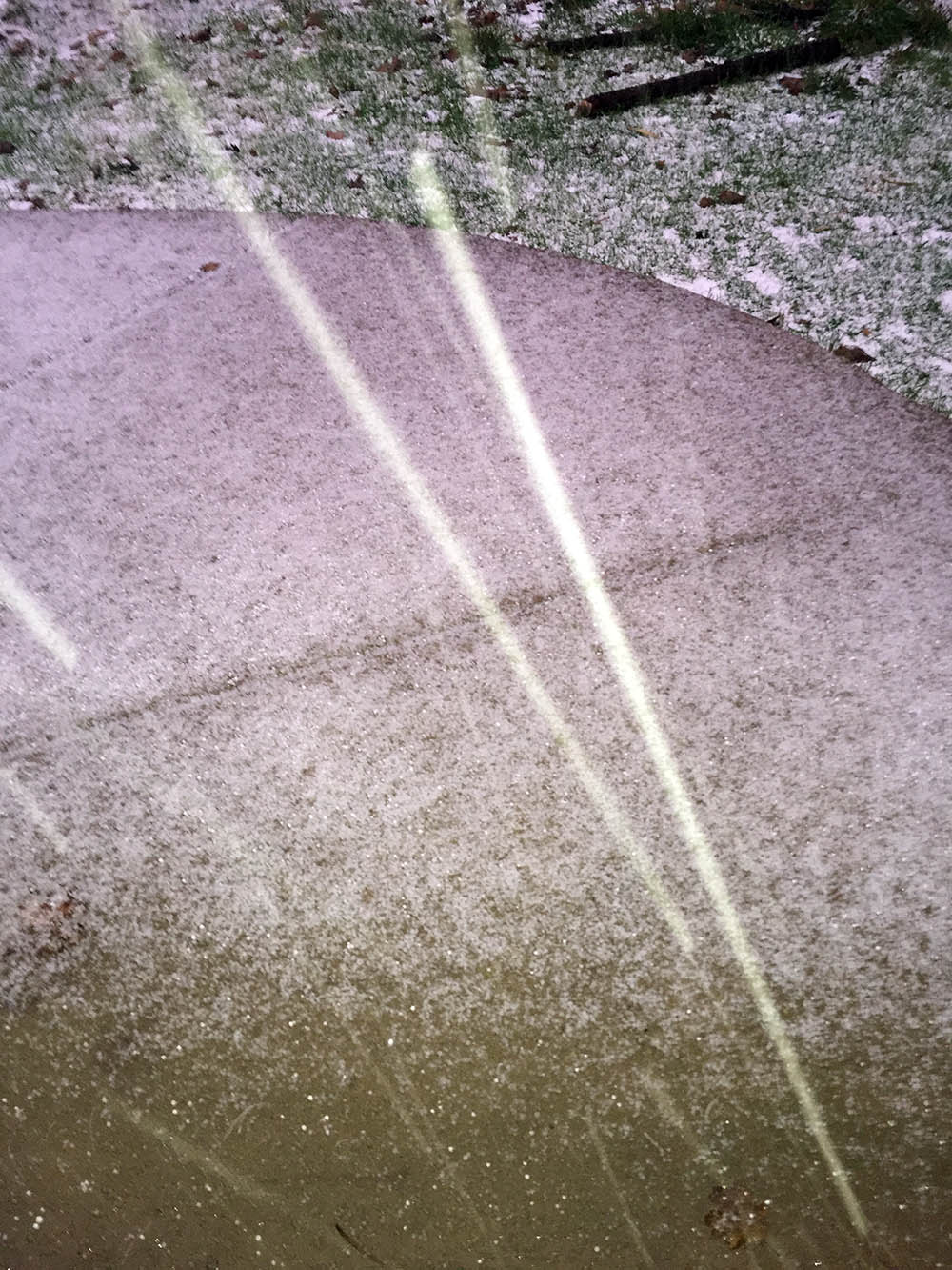
December 16, 2016 at 5:18 PM Bundle up! The streaks visible in the picture are not meteorites, just hail coming down fast and furious in Foresthill (Placer County.) Photo courtesy Bill Roush.
According to the National Weather Service in Sacramento:
“A secondary short wave will be passing just S of our forecast area through this evening. With the southeastern corner of our CWA in the NE quadrant of this energy, scattered showers will continue mainly from the I-80 corridor Swd, mainly affecting zones 67/69.
Post frontal snow levels have lowered with about a 50/50 chance of seeing snow down to around 2800 to 3000 feet.”

December 16, 2016 at 3:52 PM Heads up, this is Hwy 20 between the 5 Mile House and the Omega Overlook right now. Take your time! Thanks to Deborah and Bruce Jones for the photo.
December 16, 2016 at 7:11 AM Drying out and freezing up this weekend. This weather system that brought rain and mountain snow to northern California on Thursday has moved east of the state today. Clearing skies and warmer days are expected over the weekend but overnight lows are expected to be quite chilly. Overnight lows in the valley are expected to drop below freezing many areas both Saturday and Sunday mornings.
December 15, 2016 at 11:04 PM Tree across the roadway on Bitney Springs Road, approx. 100 yards from the Newtown Road intersection near Nevada City.
December 15, 2016 at 10:21 PM Pole and power lines down, across the road, on Combie Road at Table Meadow Road in south county. Emergency services en route.
December 15, 2016 at 8:46 PM Small debris/rocks in the road on Pleasant Valley Road at the junction of Hwy 49 in the San Juan Ridge area. Flooding on Tyler Foote and Purdon Road. Slow down and watch for debris. When in doubt, turn around.

December 15, 2016 at 8:21 PM Snow levels have dropped below the summit and are continuing to drop. Here is Donner Summit right now.
December 15, 2016 at 8:11 PM Traffic hazard reported on Dog Bar Road at Magnolia. Use caution in the area.
December 15, 2016 at 8:10 PM Roadway is flooded on McCourtney Road in front of the CHP Office and the Fairgrounds.

December 15, 2016 at 7:00 PM Per NWS Sacramento: It has been a wet December so far in the mountains. The wettest December ever at Blue Canyon is 45.12 in 1955.

December 15, 2016 at 6:30 PM Power outage is down to just 216 customers in the Alta Sierra area on Buck Mountain Road, Fairview Drive and Holcomb Drive.
Crew is on site and replacing the broken power pole – in these weather conditions.
December 15, 2016 at 5:37 PM Accident on Penn Valley Drive near Spenceville Road in the Penn Valley area. Another accident on North Bloomfield Road, north of Nevada City.
December 15, 2016 at 5:36 PM Mud and rock slide again on Hwy 49 near the Independence Trail.
December 15, 2016 at 5:02 PM Update on the Alta Sierra to Higgins power outage: Tree through power lines and a broken pole. 1,500 customers still out but PG&E is rerouting power to get most of them back online. A crew is on their way to replace the broken pole.
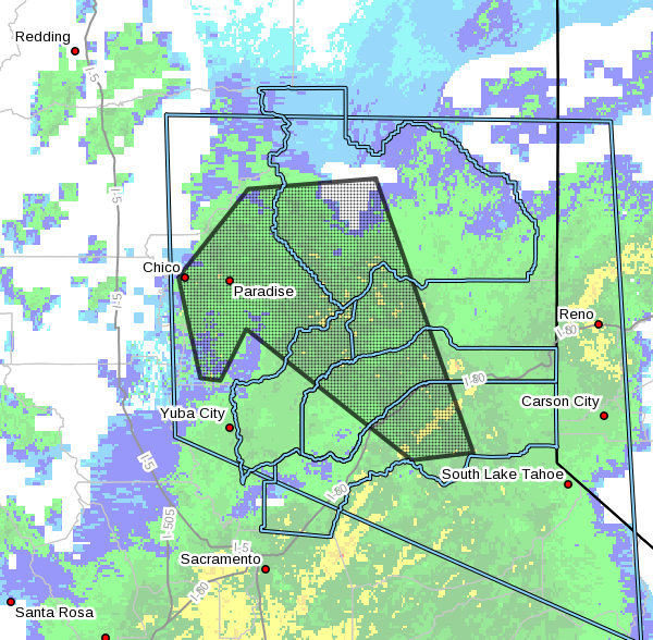
December 15, 2016 at 4:53 PM The National Weather Service in Sacramento has issued a Small Stream Flood Advisory for:
- Southern Plumas County in northern California.
- Northeastern Placer County in central California.
- Butte County in northern California.
- Sierra County in northern California.
- Northeastern Yuba County in central California.
- Central Nevada County in northern California.
until 9:30 PM PST
At 4:29 PM PST, Doppler radar indicated heavy rain that will cause small stream flooding in the advisory area. One to three inches of rain has already fallen. An additional 1 to 2 inches will be possible over the next 5 hours. Ponding water and flooding of poor drainage areas will be possible along with significant rises of small streams.
Some locations that will experience flooding include: Chico, Paradise, Oroville, Grass Valley, Brush Creek Rs, Downieville, Pulga, Baxter, Cisco, Quincy, Blue Canyon, Palermo, Gridley, East Quincy, Thermalito, Stirling City, Storrie, American House, Sugar Pine and Brownsville.
December 15, 2016 at 4:27 PM Per Caltrans: Highway 49 at Joeger in Auburn (Placer County) is all clear.

December 15, 2016 at 4:03 PM Reported electrical transformer explosion near Oak Ridge Drive, power is out in Alta Sierra down to Lime Kiln Road and Higgins Corner. No estimated time of restoration for the 1,933 customers yet.
December 15, 2016 at 1:57 PM One-way traffic control at Highway 49 at Joeger Rd near Dry Creek Road in Auburn as crews work to clear crash. ETO is 6 p.m. to reopen closed NB lanes.
December 15, 2016 at 1:36 PM A public safety warning has been posted for the Rubicon Trail for December 15-16, 2016. The weather forecast is predicting significant snow and strong winds. Travel on the trail is not advisable during this storm.
December 15, 2016 at 1:31 PM A male jumping in the roadway and yelling at cars on East Main Street, near Idaho-Maryland Road in Grass Valley.
December 15, 2016 at 1:26 PM Report of a fatal accident on Hwy 49, northbound at Dry Creek Road in Auburn. Both lanes are blocked.
December 15, 2016 at 11:44 AM Power lines down on Pleasant Street near Dalton in Grass Valley, moving van now tangled in the power lines. Grass Valley Fire en route.
December 15, 2016 at 11:41 AM Non-injury accident on Carrie Drive in Alta Sierra. Car is hanging in guide wires, tow truck en route.
December 15, 2016 at 10:15 AM Overpass of Hwy 49 at South Auburn Street in Grass Valley is flooded.
December 15, 2016 at 10:11 AM The #1 lane on northbound Hwy 49 near the Bennett Street offramp in Grass Valley is starting to flood.
December 15, 2016 at 9:33 AM Southbound Hwy 49 at Sacramento Street in Nevada City is flooded. Caltrans has been notified. Reduce your speed, use caution and your headlights.
December 15, 2016 at 9:19 AM Power outage along I80 from Lake Spaulding to Kingvale, 655 customers affected. Another 401 customers are without power in the Soda Springs/Serene Lakes area. No estimated time of restoration yet.
December 15, 2016 at 9:14 AM Flooding and driving conditions will get worse as the day progresses. Watch for ponding water, mud and rock slides.
December 15, 2016 at 8:40 AM Good advice from CAL FIRE: Just few feet of water can carry a car away. NEVER enter a flooded area. Turn Around, Don’t Drown.
December 15, 2016 at 7:55 AM NWS Sacramento: A timing loop of the Pacific front and the associated heavy rain is included to give you an estimate of when the weather will rapidly change for your area of concern. Behind the front, the coldest temperatures of the season (so far) are expected with a “Hard Freeze” possible Sunday morning.
December 15, 2016 at 7:40 AM Wet and windy weather with high-elevation snow today and tonight. A strong Pacific storm will be moving through Northern California today. Significant rainfall is expected especially over the mountains. Local roadway and minor flooding are likely. Snow levels will start out high then lower some tonight. Much lower snow levels are expected tomorrow behind the front but little additional precipitation is expected. Most locations will see gusty winds today with winds decreasing tonight.
December 15, 2016 at 7:31 AM Truckee Fire Protection District: National Weather Service is predicting the Truckee River to get close to moderate flood stage from the storm that is hitting the area today and tonight. Be prepared by picking up sand bags which are available at 11473 Donner Pass Rd (station92) along with Town of Truckee at Stockrest Springs by the Forest Service. Don’t drive through areas that are flooded, and watch for downed trees and power lines from predicted high winds through tomorrow.
December 14, 2016 at 8:42 PM Boulders in the roadway on Hwy 49 near the Independence Trailhead (again). Use extreme caution in the area.

December 14, 2016 at 7:26 PM In anticipation of the storm, Nevada County OES reminds locals that sandbags are available at the county’s facility on Hwy 49 and Broad Street in Nevada City, at the Higgins Fire Station on Combie Road and at the North San Juan Fire station. Sand and bags are provided, but please bring your own shovel. OES Manager John Gulserian estimates approximately 2,000 sandbags have been provided since Thursday. The sandpile at the county warehouse has been restocked three times Gulserian said.
December 14, 2016 at 3:45 PM The traffic signals on Hwy 49 at Combie Road in Lake of the Pines are stuck on red. Caltrans is en route.
December 14, 2016 at 8:26 AM Ten cows are wandering in the roadway on Garden Bar Road near Clayton Road in south county.
December 14, 2016 at 7:43 AM Overturned vehicle on Hwy 49 near Reader Ranch Road in the San Juan Ridge area, car is in the middle of the roadway. Emergency services en route, please use caution in the area.
December 14, 2016 at 7:35 AM Strong, gusty winds develop later today ahead of heavy precip tonight and Thursday. Rain rates will be on the upswing Thursday and Thursday night and will possibly be comparable to what we saw this past weekend. As such, urban, small stream, and burn scar flooding potential will be much higher. Winds will also be a factor as gusts of 40-60 mph will be possible, starting in the northern Sacramento Valley this afternoon and shifting southward later tonight into Thursday. Wind gusts this strong may cause downed trees and local power outages.
December 13, 2016 at 11:10 AM Pile burning in the Little Truckee Summit/Independence Lake area of the Sierraville RD–likely visible from Hwy 89.
December 13, 2016 at 9:07 AM Nevada County Sheriff’s Office confirms that one person is deceased, after a gunshot wound injury in Cascade Shores. Major Crimes Units has arrived on scene. More details as they become available, the identity of the victim has not been released.
December 13, 2016 at 8:10 AM Emergency services and law enforcement are staging in the Cascade Shores area near Pawnee Trail for a reported gun shot wound. An air ambulance has been requested.
December 13, 2016 at 7:43 AM Caltrans: Placer I-80 EB at Big Bend the #1 lane is blocked due to an overturned big rig, no injury reported. ETO 11 am.
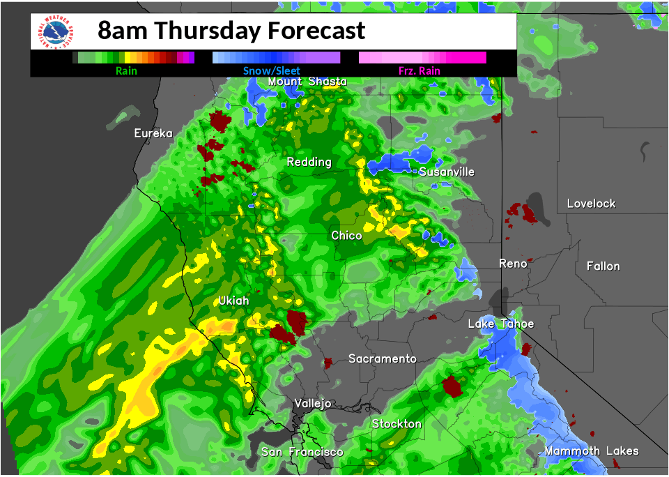
December 13, 2016 at 7:19 AM Significant rainfall and snow likely by Wednesday into Friday, gusty winds on Wednesday. A 1-2 punch of storm systems is expected to hit Northern California this week! The first will arrive Tuesday afternoon into Wednesday, with the bulk of precipitation expected mainly Interstate 80 and northward. Precipitation won’t be as heavy as this past weekend, but expect streams and rivers to continue running high. Light to moderate snow will be possible over the mountains. The 2nd storm this Thursday could bring significant impacts to the region. Urban, small stream, and burn scar flooding will be possible during periods of high rain rates. Gusty winds (possibly 45-55 mph) could bring down widespread trees and cause power outages. Snow levels will initially be very high, but heavy snow will be possible at the tail end of this storm across the mid and upper slopes. Keep staying tuned for updates on these forecast storms!
December 13, 2016 at 7:03 AM Two horses were found running free in the night near Jones Bar. A kind person has secured them. The horses are waiting for their human to claim them. Email or text us for the good Samaritan’s phone number.
December 12, 2016 at 8:02 PM Both lanes are open now on Hwy 49 between Nevada City and North San Juan.
December 12, 2016 at 7:59 PM Lanes are about to reopen on Hwy 49 near the Independence Trail after a debris slide. Expect one-way traffic control for a few hours while cleanup is ongoing. Also, use caution when driving in rockfall areas.

December 12, 2016 at 6:51 PM Per CHP Grass Valley: Estimated time to reopen SR-49 is 8:00 PM. CalTrans is working with heavy equipment to clear/repair hillside.
December 12, 2016 at 5:18 PM Mud and rockslide on Hwy 49 just past Nishenam Gulch, between Nevada City and North San Juan. Hwy 49 is closed in both directions, estimated time of closure is approximately two hours. Use Pleasant Valley Road as a detour.
December 12, 2016 at 10:52 AM CAL FIRE/Butte County firefighters at scene of a structure fire 3700 block of Olive Hwy East of Oroville (Butte Co.)

December 12, 2016 at 10:22 AM Spread some holiday cheer – subscribe to YubaNet and your favorite non-profit will benefit. Do you find the news on YubaNet useful? Are you a member of a non-profit? Then combine both! For the next two weeks, become a sustaining subscriber and we will provide free advertising to a non-profit (501 (c)3) of your choice. Pick a package that works for you, tell us which non-profit should benefit from it and we will advertise their work.
December 12, 2016 at 10:21 AM Phone line down across Brunswick Road at Old Tunnel Rad in the Brunswick Basin. The line has been cut and traffic is flowing again.
December 12, 2016 at 7:22 AM First wave of rain Tuesday/Wednesday, even bigger event Thursday/Friday – including low snow levels. Rain and snow return to the region Tuesday and continues through the end of the week. The period of heaviest precip is expected on Thursday as a cold front moves through the area.
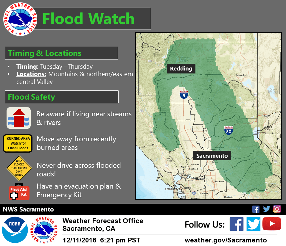
December 11, 2016 at 9:32 PM More precipitation is coming along this atmospheric river Tuesday through Thursday. Flood watch has been issued Tuesday – Thursday. Do not cross roads with moving water!
December 11, 2016 at 10:19 AM Next storm arrives Tuesday, significant rain and snow forecast. Dry Sunday and Monday followed by potentially significant rain and mountain snow Tuesday through Thursday. Winter Storm Watch from Tuesday morning through Wednesday afternoon for West Slope Northern Sierra Nevada. Another warm and wet system will move over our area bringing rain to Northern California starting Tuesday. Snow levels may initially start low (3500-5500 ft, north to south) on Tuesday but will gradually rise (5500-7500 ft, north to south) on Wednesday as warmer air moves in. Rainfall totals once again look impressive and minor street and small stream flooding will be of concern, especially for the Sierra.

December 10, 2016 at 6:46 PM Thanks to reader Bob Branstrom for the photo of the South Yuba at the 49’er Bridge, taken today at 3:45 pm.
December 10, 2016 at 6:41 PM Mud and rock slide on Hey 49 going towards North San Juan, near Independence Trail. Both lanes are affected, reduce your speed and use caution.
December 10, 2016 at 5:06 PM Vehicle into the ditch on Hwy 20 near Scotts Flat Road. No injuries reported.
December 10, 2016 at 5:06 PM Grass Valley Police: Time to slow down people! Officer on scene at this accident on southbound Hwy49 at the Idaho Maryland Off ramp lane.

December 10, 2016 at 4:27 PM Change in Forecasted flood status from No Flooding to Near Flood Stage for the Yuba River above Marysville. Previous Forecasted flood stage was: No Flooding. New Forecasted flood stage is: Near Flood Stage Forecasted 48 hour crest: 74.4 ft.
December 10, 2016 at 3:37 PM Ongoing rain, flooding in Nevada County. Wildwood Dam photo courtesy Julie Siegenthaler, Spenceville Wildlife area courtesy Kyla Halford.


December 10, 2016 at 3:28 PM Power line down on Lime Kiln Road northbound from Hwy 49 in Grass Valley. Emergency services en route.
December 10, 2016 at 2:44 PM The entire roadway on Industrial Ave/Athens Ave in Lincoln is flooded. Use an alternate route. Thanks to Barbara for the correct location.

December 10, 2016 at 1:59 PM Squirrel Creek at Gateway Park in Penn Valley – respect the closures for your own safety.
December 10, 2016 at 1:30 PM Per PG&E: Lake Spaulding is now full and water began spilling over the dam spillway at 1:05 pm today.
December 10, 2016 at 1:29 PM This just in from Truckee Fire:
South Fork of #Yuba River on #Donner Summit near #Truckee. Be safe! Sandbags available @ Station 92 on Donner Pass Rd #atmosphericriver pic.twitter.com/JrgHgTrCxM
— Truckee Fire (@TruckeeFire) December 10, 2016
December 10, 2016 at 12:33 PM Spaulding spilling, higher flows on South Yuba River this weekend. PG&E’s Lake Spaulding in Nevada County could fill and the dam could begin spilling as soon as Saturday evening as abundant rain this fall fills the reservoir.
December 10, 2016 at 12:32 PM Tree down in the roadway on McCourtney and Sugar Loaf Road in Grass Valley.

December 10, 2016 at 12:10 PM The Food&Toy Run is about to take off. Smaller group of riders this year, but a big crowd already at the Fairgrounds.
December 10, 2016 at 11:53 AM The Flood Warning continues for the Truckee River near Truckee.
* FROM THIS AFTERNOON TO SUNDAY AFTERNOON.
* At 9:00 AM Saturday the stage was 3.7 feet.
* Flood stage is 4.5 feet.
* Moderate flooding is forecast.
* Forecast: Rise above flood stage by Saturday afternoon and reach a crest near 5.8 feet. The river will fall below flood stage by late Saturday evening.
* Impact – At 6.0 feet: Moderate flooding from Bear Creek in the Alpine Meadows area to Truckee, about 4200 cfs. Flooding of yards and basements of low-lying homes along river…some private bridges impacted.
December 10, 2016 at 11:51 AM Tree across all lanes on Hidden Ranch Road at Hwy 49, power lines down. PG&E, fire on scene.
December 10, 2016 at 11:49 AM Sandbags are available at the county’s depot at the intersection of Hwy 49 and East Broad Street. Bags are provided, bring your own shovel.

December 10, 2016 at 11:27 AM Safety message: Do not attempt to cross flooded roads and report any downed trees in power lines or on roadways immediately to 911.
December 10, 2016 at 11:22 AM NWS Sacramento: A flood advisory has been issued for the Sierra and foothills due to heavy rain and high snow levels!

December 10, 2016 at 11:13 AM The South Yuba in the Town of Washington, as seen from the bridge. Thanks Katy Potter for the picture.
December 10, 2016 at 11:12 AM Large tree branch hanging in the power lines and onto the roadway on McCourtney Road at Perimeter Road.
December 10, 2016 at 11:08 AM San Juan Ridge area: Flooding on Tyler Foote Road between Ananda Village and Mother Truckers, “where the old barn used to be.” Also, rock and mudslides on Pleasant Valley Road coming from the North San Juan direction – with one half way down blocking most of the road. Thanks to Kimi Barnes and Sara Greensfelder for the updates.
December 10, 2016 at 11:07 AM Flooding on Dog Bar Road south of Norlene Way in Alta Sierra.
December 10, 2016 at 11:05 AM Tree down on a power line on Combie Road, just past the Higgins Fire station.
December 10, 2016 at 9:14 AM Nevada County Food and Toy Run info: All you guys coming up from Sacramento, Yuba City, Chico, etc. If you cancel, that is fine. We have the food for the families, maybe a tad short of toys. The wind is what concerns us. Might be too dicey on a loaded bagger. If you come in a car, go straight to the Fairgrounds. We can’t have cars with the bikes in the Run. I think we will have a small pool of local riders. It will be a short Run this year. Thank you for your support and positive attitudes! Don’t worry, all with be fine!
December 10, 2016 at 8:34 AM Roadway flooding throughout Nevada County. Please be extremely careful and do not attempt to drive through flooded areas.

December 10, 2016 at 8:28 AM From Grass Valley Police: Wolf Creek has crested Mill Street in many locations. There is also moderate flooding to many surface streets throughout Grass Valley. Please be careful and keep speeds at a minimum!
December 10, 2016 at 1:43 AM Caution on Hwy 49 near Lime Kiln. A disabled big rig is partially blocking lanes. Use extreme caution in the area and reduce speed.
December 9, 2016 at 9:42 PM Help out reader Susan Reuter: “Please pass around. My 1995 Honda accord was stolen today Dec 9, 2016 from Bridge Street, Nevada City CA. It’s champagne color, 4 doors, major dents on driver side and rear wind shield has Plan It Solar sticker with my phone number, call police or me if you see it. 530 575 7465 Thanks.”
December 9, 2016 at 11:31 AM Non-injury accident in Alta Sierra at Norlene Way / Tippy Way.
December 9, 2016 at 10:16 AM Accident on Rough&Ready Highway near North Ponderosa Way, use caution in the area. Emergency services en route.
December 9, 2016 at 9:45 AM Non-injury vehicle accident on Pleasant Valley Road near Wildflower Drive in Penn Valley.
December 9, 2016 at 8:27 AM At times heavy precip Saturday, a short break on Sunday, then more of the same. A series of Pacific weather systems will likely bring periods of wet weather to northern California over the next week. The first arrives later today, continuing through Saturday night. Valley precipitation will be mainly light, with moderate to heavy precipitation over the mountains. Snow levels will be initially very high, but mountain travel may be impacted Saturday evening and night as snow levels lower below pass levels. Additional weather systems will be possible mid-to-late next week.
December 8, 2016 at 11:23 AM Highway 20 at Spring Valley Road east of Hallwood is ALL CLEAR.
December 8, 2016 at 10:32 AM Caltrans: Highway 20 at Spring Valley Road near Hallwood (Yuba County) is closed due to power pole down in roadway. No ETO.
December 8, 2016 at 8:40 AM Wet pattern through the weekend, extending into next week. A series of Pacific storms will bring wet weather to northern California over the next several days. Low elevation snow levels will be present over Shasta county this morning but will rise quickly as the day progresses. Valley precipitation will be mainly light in nature with moderate rain and higher elevation snow at times expected over the mountains.
December 7, 2016 at 10:51 PM Chain control is in effect on Hwy 20 at the Omega overlook.
December 7, 2016 at 5:46 PM Snowing over Donner Summit, watch for snow removal vehicles and avoid travel over the summit if you can.
December 7, 2016 at 1:14 PM Former Grass Valley Police Chief John Foster announced his candidacy for the 2018 Nevada County Sheriff’s election.
December 7, 2016 at 9:12 AM One southbound lane is blocked on Hwy 49 just north of Wolf Road, use caution in the area.
December 7, 2016 at 8:48 AM CAL FIRE plans to conduct a 25-acre prescribed burn at the Mt Howell Lookout property today. The burn will begin around 10:00 a.m. and continue into the afternoon hours. Smoke will be visible from Interstate 80 between Colfax and Weimar and in the general surrounding areas.
December 7, 2016 at 8:41 AM The Tahoe National Forest will burn piles today at White Cloud on Hwy 20. Smoke and possibly flames will be visible, starting at 9 am. There is no need to report the fire, crews are on site. Motorists are advised to slow down and watch for equipment.
December 7, 2016 at 8:34 AM Waves of significant precipitation starting tonight. It’s getting active out in the Pacific Ocean! Several weather systems are lining up to impact Northern California in the next week. The first system arrives Wednesday afternoon/evening, and is likely to bring initially low snow levels to the mountains. The next arrives in the Friday timeframe, and will probably bring precipitation in a narrow corridor. Potentially even wetter systems arrive next week!
December 6, 2016 at 8:02 PM Per Caltrans: I-80 westbound from Stateline one lane has reopened due to big rig rollover crash. Cleanup continues.
December 6, 2016 at 4:18 PM Per Caltrans: Westbound I-80 traffic being turned at Nevada line due to overturned big rig across all lanes just west of the state line. Anticipate delays.
December 6, 2016 at 12:36 PM Non-injury accident in front of the Salvation Army on Alta Street in Grass Valley.
December 6, 2016 at 7:29 AM Freeze tonight, low snow levels possible starting Wednesday night. Another night of chilly temperatures lies ahead for interior NorCal. Readings in the Central Valley are once again expected to dip down into the upper 20s and lower 30s.
December 6, 2016 at 7:20 AM The National Weather Service in Sacramento has issued a dense fog advisory, which is in effect until 10 am this morning. Visibility can be less than a quarter mile at times. Areas affected: Central Sacramento Valley, Southern Sacramento Valley, Northern San Joaquin Valley, including the cities of Chico, Oroville, Marysville/Yuba City, Sacramento, Stockton and Modesto.
December 5, 2016 at 5:20 PM North San Juan firefighters have located an almost burned-out vehicle on Jackass Flat Road. The vehicle is surrounded by gravel, no danger of the fire spreading
December 5, 2016 at 5:07 PM CAL FIRE firefighters have searched the Tyler Foote area and are unable to locate the reported vehicle on fire.
December 5, 2016 at 4:55 PM Reported vehicle on fire on Tyler Foote and Jackass Flats on the San Juan Ridge. Fire is en route.
December 5, 2016 at 4:00 PM One cow in the roadway on Hwy 49 at Tyler Foote on the San Juan Ridge.
December 5, 2016 at 3:50 PM Six cows in the roadway on Indian Springs Road near Maidu Trail in Penn Valley.
December 5, 2016 at 2:02 PM Vehicle vs tree on the 16000 block of Garden Bar Road near the Vineyard.
December 5, 2016 at 11:36 AM Car fire on southbound Hwy 49 at Cherry Creek. Fire personnel is on scene and reports the fire as extinguished.

December 5, 2016 at 8:56 AM Cold weather is expected the next couple of mornings, and may bring areas of frost to the Central Valley. Tuesday night should be the coldest night across the region. A series of weather systems will then bring rain and snow across much of the region Wednesday through Saturday. Snow levels are expected to start rather low, then rise on Thursday. The forecast trend has been to shift the heaviest precipitation band south of Interstate 80.
December 5, 2016 at 8:07 AM Freeze tonight and tomorrow night, Atmospheric River coming in on Wednesday. Another shot of cooler air will move into the region tonight and Tuesday as another weak system clips us as it drops down in northwest flow. A few snow showers are expected in the mountains before tapering off by early Tuesday evening.
December 4, 2016 at 8:51 AM Jim Hurley: Strategies to Keep Pipes From Freezing. Some practical advice from the Lake Vera/Round Mountain Home Owner’s association newsletter.
December 3, 2016 at 8:00 AM Sunny and dry today, then below freezing temps and snow next week. An upper level high pressure system in the eastern Pacific will provide mostly sunny skies across northern California today. Temperatures will range between 5 and 10 degrees above normal. Cooler weather will be on the way for the coming work week.
December 2, 2016 at 5:09 PM Per CHP Gras Valley: McCourtney Rd is clear. The motorcycle rider was flown/helicopter to a trauma center, serious injuries, suspected DUI.
December 2, 2016 at 3:25 PM Traffic control on McCourtney Road will be lifted shortly, air ambulance is en route to Sutter Roseville with the injured motorcycle rider.
December 2, 2016 at 3:25 PM Strong smell of propane across from the Colfax Elementary School. Units en route.
December 2, 2016 at 3:16 PM Air ambulance en route to an accident in front of Grass Valley CHP HQ on Mc Courtney Road in Grass Valley.
December 2, 2016 at 8:43 AM Armstrong Fire Safety has another prescribed burn today. This will be at the Golden Chain Motel just south of town in Grass Valley. Smoke and flames will be visible from the highway. We’re urging drivers to stay alert and use caution if driving through the area today.
December 2, 2016 at 8:03 AM Breezy north winds continue, hard freeze and low snow by Tuesday morning. Light showers and cooling temperatures Sunday into Monday mainly north of Sacramento and over the northern Sierra. Turning much colder Tuesday through mid week.
December 1, 2016 at 7:37 AM Breezy north winds today and Friday. Building high pressure over the Eastern Pacific will bring breezy north winds to northern California today through Friday. The strongest winds are expected this evening and over the west side of the Sacramento valley and coast range. As the high pressure shifts inland Saturday, the winds will decrease while daytime temperatures warm.
December 1, 2016 at 7:29 AM If you are looking for last month’s log, you can find it here. The featured image is a Great Blue Heron who visited YubaNet HQ a while back.