July 23, 2017 – Another hot day today especially northern Sacramento valley and surrounding foothills. A slight threat of afternoon and evening thunderstorms over the Sierra Cascade crest through early this week spreading northward into Shasta county Tuesday. Cooler temperatures Monday and Tuesday with a slow warming mid to late week. Heat Advisory until 9 PM this evening.
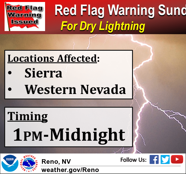
A Red Flag Warning has been issued for Sunday for the threat of new fire starts from dry lightning strikes. Moisture will filter into the region Sunday which will allow for a scattered mix of wet and dry thunderstorms Sunday afternoon and evening. Any dry lightning strikes will cause new wildfires in the area. Gusty outflow winds up to 50 to 60 mph are possible in the vicinity of these storms. New fire starts may combine with strong outflow wind gusts to cause fires to rapidly grow in size and intensity before first responders can contain them.
Discussion
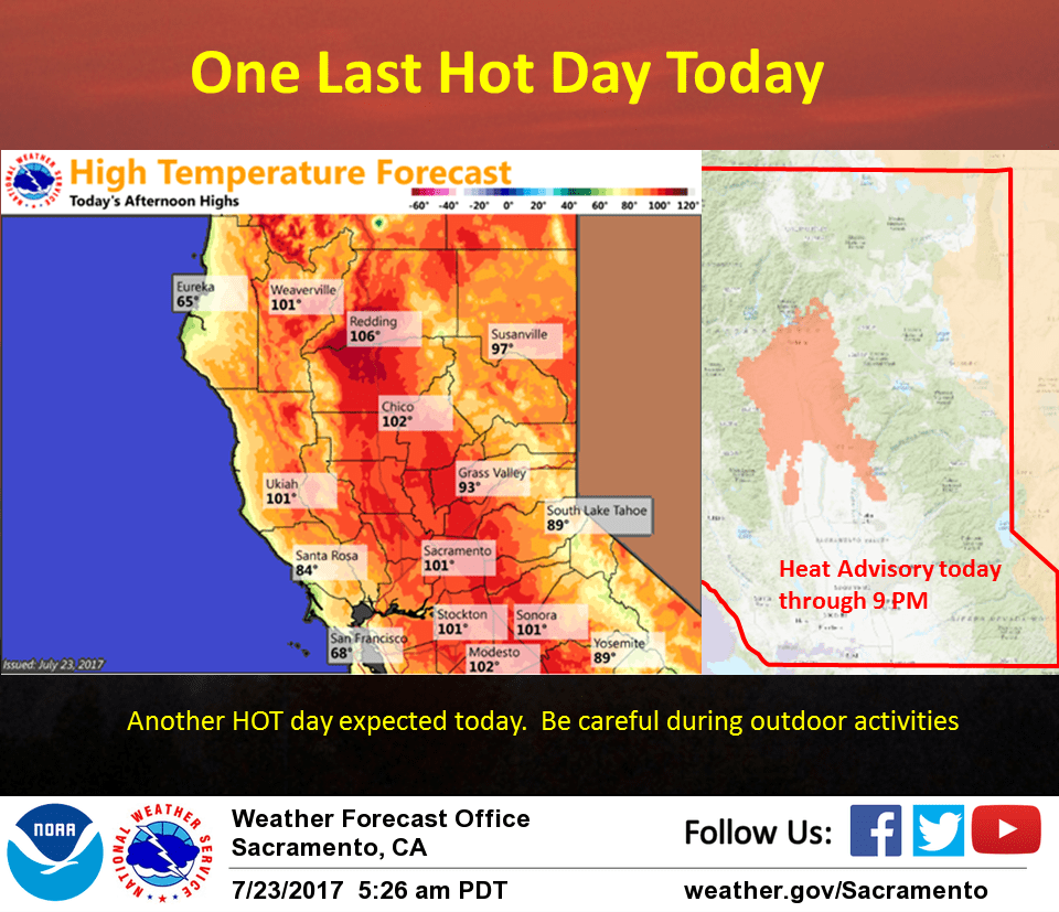
Northern California currently under southerly flow aloft between high pressure over the southwest U.S. and a weak upper low off the Norcal coast. Just a few high clouds moving northward through the region this morning but otherwise the north state is under fair skies. Overall airmass similar to Saturday so should see daytime highs today similar to Sunday. Therefore, will leave heat advisory currently in place through this evening as is.
South to southeast flow over the Sierra Cascade crest will bring up enough moisture and instability for a threat of isolated afternoon or evening crest thunderstorms.
Upper low over eastern Pacific starts pushing inland into Norcal on Monday. Airmass cooling and onshore flow will bring down daytime highs close to normal for this time of year. Models still showing enough instability and moisture for a threat of afternoon Sierra crest storms.
Upper low center forecast to move onshore by mid day Tuesday keeping daytime highs close to season normals. As always with closed type lows, forecast models will be at least a bit inconsistent but a more southeast wrap around type flow over Norcal could bring afternoon thunderstorm threat more westward over the higher elevations of Shasta county.
Upper low center forecast to lift to the northeast on Wednesday so temperatures will begin to trend back up again going into the extended period. Southwest to west flow aloft should shunt monsoon type moisture eastward. More stable conditions and less moisture should end mountain thunderstorm threat across the CWA.
Extended discussion (Thursday through Sunday)
High pressure will rebuild over the Great Basin late this week, expanding westward and bringing hotter than normal weather across the region. The current forecast calls for temperatures near or above the century mark across the Valley throughout the period, with 70s to 90s over the mountains. Current projections keep monsoonal moisture south and east of the region, though forecast confidence isn’t high in this solution just yet.