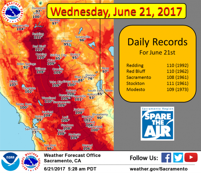
June 21, 2017 – Extended heat wave with widespread highs over 100 degrees and warm nights through Friday. Isolated afternoon thunderstorms possible over the mountains today. Red Flag Warning from 1 PM this afternoon to 11 PM Thursday.
Discussion
Clear skies across interior NorCal early this morning. The Delta Breeze continues to bring cooling into the Sacramento region where temperatures are running around 4-8 degrees lower than 24 hours ago. On the other hand, developing northerly flow across the northern Sacramento Valley is keeping temperatures in the mid to upper 80s around Redding and Red Bluff.
Elsewhere, current temperatures are mostly similar compared to early Tuesday and generally range from the mid 40s to mid 50s in the mountain valleys to the lower 80s across warmer portions of the Central Valley.
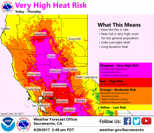
Northerly flow gradually spreading southward will reduce flow thru the Delta. Hotter temperatures will be the result with record and near record heat again. The high heat, low relative humidity’s and increased winds will lead to high fire danger for a number of areas.
A very weak wave will linger over the region today and will likely again help a few thunderstorms to develop over the mountains later today.
Ridge strengthens again on Thursday and northerly surface flow continues. This will suppress the marine layer and result in the hottest day of the week for most of interior NorCal.
Hot weather will continue into the weekend, but temperatures are expected to be not quite as hot Friday and especially Saturday as the ridge weakens and onshore flow gradually returns.
Extended discussion (Sunday through Wednesday)
Axis of upper ridge which has brought extended period of hot weather is forecast to shift inland on Sunday. The two effects of this will be a slight cooling of the airmass and an increased onshore flow through the delta. Most locations will see a few to several degrees of cooling with the greatest drop in temperatures in the delta influenced areas. GFS showing instability over the northern Sierra Sunday afternoon with southerly flow aloft for a slight threat of afternoon or evening thunderstorms.
Still more cooling is expected on Monday as troughing develops over the eastern Pacific. Valley locations should see max temperatures finally all below the century mark. Southwest flow aloft should ensure stable conditions and keep any thunderstorm activity out of the forecast area. Cooling continues on Tuesday as weak upper trough pushes inland over the coast with onshore flow and delta breeze increasing. Little change in the forecast for the middle of next week with weak upper troughing and stable conditions continuing.