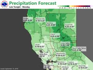
September 15, 2019 – Pattern change will lead to significantly cooler temperatures and a chance of showers and thunderstorms late this evening into Monday. Another system could bring additional showers by midweek. Dry weather and warm temperatures return late this week.
For the East side of the Sierra: Strong, Long Duration Red Flag Event Sunday Into Monday. Particularly Dangerous Situation (Pds) In The Foothills Along And West Of Highway 395 And Interstate 580.
The strong wind event is just beginning at this time with ridge winds gusting to 50 mph and poor recovery. Some localized valley areas are already seeing Red Flag conditions such as Stead which has been gusting 35-40 mph with 9% RH the past hour.
Winds aloft continue to increase today and peak tonight. Very dry air will mix down today with single digit and teens RH. Wind gusts of 35-45 mph are likely in most areas today through Monday. For wind prone areas near Highway 395, some downslope enhancement is expected which will result in gusts up to 60 mph. For this reason, the PDS wording was included for these areas. Any fires that start in this area would be susceptible to extreme growth in a short period of time.
The winds will continue into Monday. While RH will increase tonight, it won`t be that much and would still be capable of supporting fire growth with the strong winds. On Monday, RH will increase with showers expected behind the front. For northern areas, the showers and moisture increase will begin sometime Monday morning, but not until the mid to late afternoon for Mono and Mineral Counties. Wetting rains are expected north of I-80 with some areas in the northern Sierra seeing 1/2 inch or more.
Discussion
Significant cooling is expected Sunday into Monday as heights lower across the region in response to an approaching strong upper-level trough. This system will bring precipitation chances for most areas, as well as breezy to gusty winds especially over the Delta and the Sierra crest. Today`s highs will be near or slightly below average, with Valley highs in the mid to upper 80s.
Southwesterly winds will increase in advance of this upper-level trough. Gusts up to 30-40 mph will be possible near the Sierra crest this afternoon and Monday. This could result in a brief period of enhanced fire weather conditions across the Sierra today, though the expected precipitation should help mitigate fire weather concerns.
Deterministic and ensemble guidance indicate rain showers spreading into Shasta County and the Coastal Range late this evening, then reaching the I-80 corridor around mid morning Monday into the early afternoon hours.
Forecast soundings indicate the potential for isolated thunderstorms on Monday, generally from Sacramento northward including the Valley and higher terrain.
At this point, the most likely timeframe for convection appears to be late morning into early evening. Forecast rainfall totals are around 0.10-0.45″, and up to 0.85″ over the mountains. Locally higher amounts are possible if storms develop. Snow levels should remain relatively high as bulk of precipitation moves in, but could briefly lower to around 6500 ft in convection. Coolest temperature readings of the week are expected to occur on Monday, with daytime highs as much as 10 to 25 below average.
The upper-level trough is forecast to shift east of the state by early Tuesday, ending precipitation threat across interior NorCal. However, this dry period should be short-lived as another system takes aim at the West Coast by midweek. At this point, it appears that precipitation will approach the northwestern portions of the forecast area by late Tuesday night/early Wednesday, with best chances over the foothills/mountains. In addition, guidance suggests the potential for thunderstorm development at least over higher terrain Wednesday afternoon. Below normal temperatures will continue on Wednesday, with Valley highs in the mid 70s to low 80s.
Extended Discussion (Thursday through Sunday)
Threat for showers continues Thursday over the mountains behind the exiting mid-week trough. Warming and drying expected by the end of the week in response to building ridge along the West Coast.


