Chances of moisture (not a bunch) increasing with best chances on Sunday. Cooling definitely on track with coolest day Sunday. Some gusty winds possible early next with temperatures slowly rising.
Discussion
Clear skies cover the region. Extensive stratus covers the Bay Area and profiler data indicates the marine layer has deepened to 2-2.5k ft. IR difference imagery shows stratus moving into the valley south of Travis, and narrowing temp/dew point spreads indicate potential for early morning stratus making it inland into the Sacramento region. Surface pressure gradients continue to mostly trend toward increased onshore flow, and most locales are seeing cooler temperatures compared to 24 hours ago.
The cooling trend will continue today as a weak trough lingers over NorCal in the wake of the stronger system that moved through the PacNW yesterday. Highs today will be down several degrees compared to Wednesday, and increased onshore flow will bring higher humidity further inland across the Central Valley and foothill elevations.
Temperatures will hold steady, or increase a few degrees, on Friday as short-wave ridging moves in ahead of the deeper weekend trough.
Cooler weather is forecast to really take hold beginning Saturday as deeper southwest flow spreads across the region with the approaching trough. Highs will cool to around 5-10 degrees below average as onshore flow picks up. Gusty southwest winds are likely for much of the region, and particularly for areas along and east of the Sierra/Cascade crest. Humidity will be increasing in that area, so fire weather concerns will be mitigated somewhat.
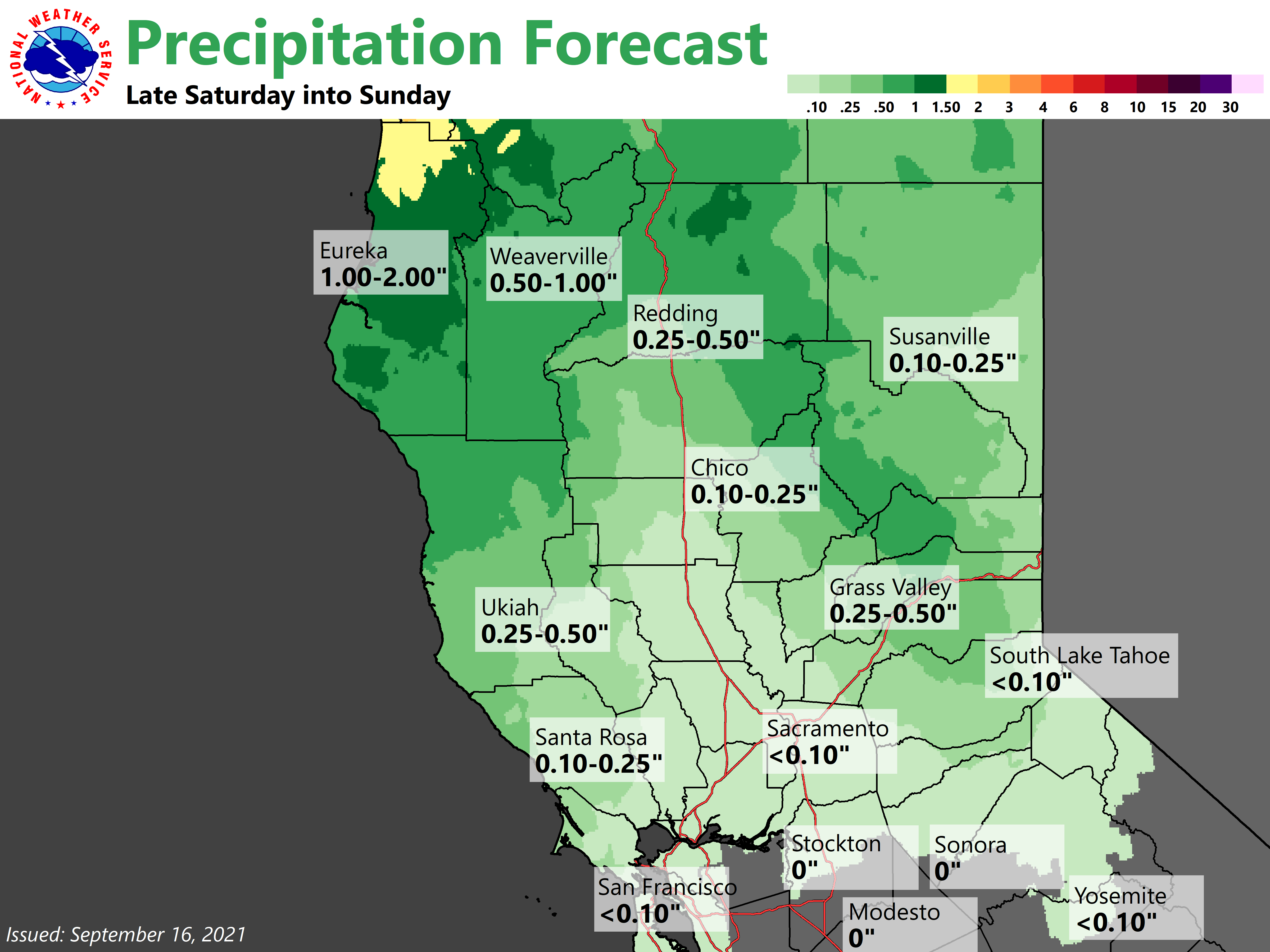
GEFS has slowed onset of precipitation to mainly late Saturday night and Sunday (now more in agreement with the EC ensemble). Mountain areas, especially north of I-80, may see QPF in excess of half an inch. Most of the valley will likely only see a few hundredths of an inch up to potentially around a quarter inch up by Redding. Hopefully consistency will continue to improve as the system get closer.
Extended Discussion (Monday through Thursday)
The upper level trough that will bring us shower chances on Sunday will be pushing to the east into the Great Basin for the start of the extended period. This will bring an increased pressure gradient over NorCal as the upper level ridge builds in from the west.

This will bring the potential for fire weather concerns on Monday as north and east winds pick up. Currently looks like gusts to 25-35 mph mainly over the northern Sac Valley and over the Sierra Monday morning. The main uncertainty with Monday is how dry humidity will get given the expected rainfall on Sunday. Short wave ridging builds in Tuesday with lighter winds and warmer temperatures.
Models then dig a trough out of the Gulf of Alaska Wednesday into NorCal. There is a lot of uncertainty with this trough and ensembles do not have a good idea of timing and placement with it. Unlike the trough on Sunday there won’t be much moisture with it and the impacts will be minimal. Upper level ridging and warming temperatures build in behind the trough.