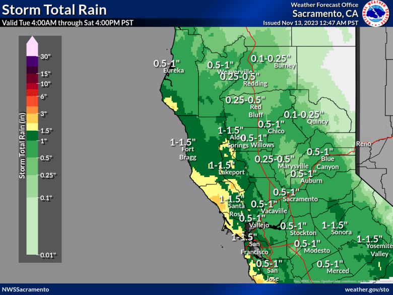
Last day of quiet weather on Monday before unsettled pattern brings widespread showers for the area and light snow accumulations over the Sierra. Precipitation totals trending down as system slows on approach to the area.

Discussion
Temperatures around the area are holding the mid 40s and low 50s, with some higher terrain locations in the Sierra seeing below freezing readings at this hour. Latest GOES-West imagery shows upper level clouds moving across the Coastal Range into the northern Sac Valley area. Cloud coverage is expected to linger around the area today as the approaching Pacific NW low begins to move south off shore.
Ensembles still favoring the Pacific low digging further south and well offshore Monday with a troughing pattern setting up in the northern portions of the country. There has been good model agreement with a slower progression of the system and becoming cutoff from the parent trough, which has led to drastically reduced rainfall totals over the course of the week. Ridging to our east is also helping slow the progression of the system, but will eventually break down Tuesday and allow the low to begin to move slow towards to east.

Our next shot at precipitation for the area arrives Tuesday morning and spread eastward throughout the day, mainly for areas north of I-80. Wednesday through Thursday still appears to be when we will have a larger areal extent of rainfall across the area, as the east ridge breaks down further and allows the low to move closer to the coast.
Right now, the NBM is projecting a general 10-50% chance of meeting or exceeding 1″ of total rainfall for the extent of this system, which is far less than previous forecasts. WPC guidance continues to trend precipitation totals downwards as well, with a general 0.25″ to 0.50″ total for Valley locations and 0.50″ to 1.00″ for higher terrains in the Sierra.
High temperatures during this time will be in low to mid 60s for Valley locations 40s to mid 50s for higher terrains. Along with the rainfall, some accumulating snowfall is expected in higher elevations during the week.

As with the rainfall totals, snowfall accumulations have trended significantly downwards too, as the system stalls and warmer air is ingested from the south into the low over the Pacific. Tuesday, snowfall looks to be contained to near Lassen National Park, with minor accumulations and impacts. On Wednesday and Thursday, as moisture moves further south snowfall may accumulate along and south of Highway 50. Snow levels are currently forecasted to increase to 7000-8000 feet as the low is trending warmer. NBM probabilities have backed off this morning, with only a 10-20% chance of locations at the highest elevations receiving 8″ or more. A general 1-3″ of snowfall is currently forecasted, with a possibility of 5-7″ near Lassen National Park through Thursday afternoon. Currently, snowfall is expected to be above Donner Pass and Echo Summit, but there may be some impacts further south to the Ebbetts and Sonora Passes.
Extended Discussion (Friday through Monday)
Closed upper low off the CA coast Friday is modeled to begin weakening to trough as it progresses. Best chances for showers Friday look to be over western and southern two-thirds of forecast area, south of KCIC.
Feature has weakened to upper trough by Saturday morning with model differences continuing on how quickly it progress through CA. Slower GFS/NBM keeps highest POPs over the Sierra Saturday.
Additional QPF Fri/Sat looks to be a few tenths in S Sac/N San Joaquin Valleys and around a third to near half inch in portions of our Sierra Nevada zone. Snow levels expected above 7000 ft.
Drier weather Sunday into Monday as models showing interior NorCal coming under high amplitude upper ridging. NBM POPs for Monday look unrealistic at this time given progged upper ridge.
