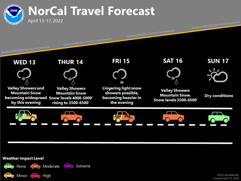
Cool temperatures continue with a pair of storms bringing rain and mountain snow Wednesday into Saturday. Warmer with dry weather expected Sunday. An unsettled pattern is expected next week with the potential for more rain and mountain snow.

Discussion
The first of two storms is spreading into the area, with radar showing returns over northwestern Shasta and Tehama counties. A weather spotter in Sims in far northwest Shasta County reported light snow earlier today.
Rain and mountain snow is expected to move across the rest of the area tonight. A Winter Weather Advisory is in effect for elevations above 4,500 feet from 5 pm this evening to 1 pm Thursday, and to 11 pm Thursday night for elevations then above 5,500 feet as snow levels rise.

Mountain highways such as I-80 and Highway 50 will likely see slowdowns and chain controls at times. Confidence in this storm has increased as well as precipitation amounts, with accumulations of 8 to 14 inches expected to Sierra pass levels, locally higher over mountain peaks.
Light snow accumulations are possible late Thursday night through Friday, but this period will be a bit of a lull before a second storm arrives Friday night and continues through Saturday. Mountain travel conditions may see some improvement.

Rainfall amounts Wednesday night through Friday night range from a few hundredths of an inch over the northern San Joaquin Valley, to around half an inch over the northern Sacramento Valley. The foothills could see a quarter of an inch to around 2 inches of rainfall.
The second system could bring similar rainfall amounts Friday through Saturday. This will be a warmer system, so snow levels will be higher, starting near Sierra pass levels around (7,200 feet) over the northern Sierra, 6000 feet over the southern Cascades Friday night.

Heaviest snow is expected Saturday morning, with snow levels down to 5,500-6,000 feet. Snow amounts of around a foot are possible at pass levels, higher amounts over peaks. This will likely bring more holiday weekend travel impacts.
In addition to the return of precipitation, gusty southerly winds have developed today and will continue into Thursday as surface pressure gradients tighten with the approach of the frontal system. Gusts to 20 to 30 mph are possible, strongest Thursday afternoon.

Sunday looks to be dry, sunny and mild, with highs in the Valley and Delta into the low 70s as high pressure ridging builds in. Pleasant weather for most outdoor activities.
Extended Discussion (Sunday through Wednesday)
Ensembles trending towards a return to an unsettled pattern next week. Confidence has improved in some early week rain and mountain snow. Current timing is for precipitation later Monday into Tuesday, but cluster analysis suggests high uncertainly in the exact timing details at this point. Other systems may move in later in the week.
