February 15, 2017 – Wet weather returns later today with several rounds continuing into next week.
Discussion
Upper ridge is beginning to give way as the developing storm over the eastern Pacific approaches NorCal. Clouds have been increasing overnight and some areas of light precipitation have begun to show up on radar off the northwest coast of California. Early morning temperatures are considerably milder compared to the past few days and generally range from the 20s and 30s in the mountain valleys to the mid 40s to lower 50s elsewhere.
Some light warm-advection precipitation will develop across far northern California today, but much of the region should remain dry until tonight.
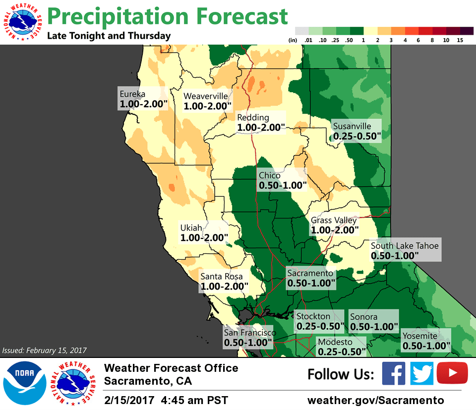
Heavier precipitation is currently expected to move through the region late tonight into Thursday morning. Precipitation from this first storm will be focused along and north of I-80 where the Sacramento Valley may see 0.50 up to 1.50 inches while the foothills and mountains may receive around 2-4 inches. Amounts to the south of I-80 will be lighter.

This storm is now looking a bit colder than previously projected. Snow levels now look like they should hover between 5000-6000 feet, which would impact major northern Sierra Nevada passes. This would additionally mean less runoff into northern Sierra reservoirs. A quick 6 to 12 inches of snow will be possible at elevations above 5500 feet, with up to 2 feet possible across Lassen Park and ski resorts. A Winter Storm Watch has been issued to address this.
It’s looking like the brunt of Friday’s storm is heading toward SoCal with lighter QPF and not as much wind for NorCal. However, with snow levels remaining around 5-6K, winter weather impacts may continue across the higher elevations of the northern Sierra Nevada.
Showers expected to taper off Saturday as brief ridging returns.
Extended discussion (Sunday through Wednesday)
Sunday looks to be somewhat in between systems under a flat ridge. We will see plenty of cloudiness and lingering showers, especially over the mountains.
The next frontal system will move inland Mon with increased dynamic and strong southerly low level winds into Tuesday. The stress on the Oroville Dam system will be somewhat lessened as Sierra Nevada snow levels fluctuate around 4000 to 5000 ft Sunday to Tuesday. This limits the amount of runoff making it down into the reservoirs.
Early rainfall estimates Sunday through Tuesday night are from 1 to 2 inches in the Valley and 3 to 5 inches in the mountains with 1 to 3 feet of snowfall above roughly 5000 feet. The USA West Coast Atmospheric River Tool indicates the precip water plume should affect the area mainly from Monday into Tuesday.