February 16, 2017 – Wet weather returns today with several storm system passages expected through next week. Sierra mountain travel issues at times. Gusty winds today and Monday. Increased flood threat Monday.
Winter Storm Watch from late tonight through Saturday morning for West Slope Northern Sierra Nevada-Western Plumas County/Lassen Park.
Flash Flood Watch through Friday morning for Carquinez Strait and Delta-Central Sacramento Valley.
Flash Flood Watch for the auxiliary spillway at Oroville Dam.
Wind Advisory until 10 AM PST this morning for Northeast Foothills/Sacramento Valley-Northern Sacramento Valley.
Discussion
Current radar indicates incoming Pacific frontal system moving into NorCal with front edge along a line from about the Burney area to the San Francisco Bay area. MFR-SAC surface gradient topped 10mb earlier this evening ahead of the front and RBL has responded with sustained winds above 21 knots last couple of hours verifying wind advisory now in place for northern Sacramento valley. Lightning detection not showing any strikes yet but stability progs show an area of instability just behind the front by mid day over the Shasta county area with this instability shifting southward into the central Sacramento valley this afternoon. Added slight threat of t-storms for Shasta county late this morning to catch possible initial lightning activity.
Winds drop off this afternoon after frontal passage. Other short term issue is Sierra snowfall where several inches to up to a foot highest elevations is expected. Gusty winds will add to travel hazard. Winter weather advisory in place looks sufficient considering limited snow and expected drop off in production this afternoon post front. Latest RFC guidance dropped off QPF this afternoon over the Sierra to match with latest runs so ending advisory at 4 pm looks good.
Some light precipitation will be possible tonight under moist southwest flow aloft but precipitation amounts will be minimal. Next Pacific storm system to impact the north state will move onshore during the day on Friday. Main energy from this system still on track to dig southward into SoCal. Therefore, precipitation amounts with this system should not be overly high but with moderate snow levels, at least minor mountain travel impacts are still expected.
NorCall remains under a narrow trough on Saturday so showers will remain in the forecast but significant precipitation amounts are not expected and instability not showing up enough to warrant t-storm threat anywhere at this time. A light shower threat continues on Sunday as upper shortwave disturbances ripple through southwest flow aloft. Winds and precipitation increase rapidly Sunday night as a stronger, moister Pacific storm moves onshore.
Extended discussion (Monday through Thursday)
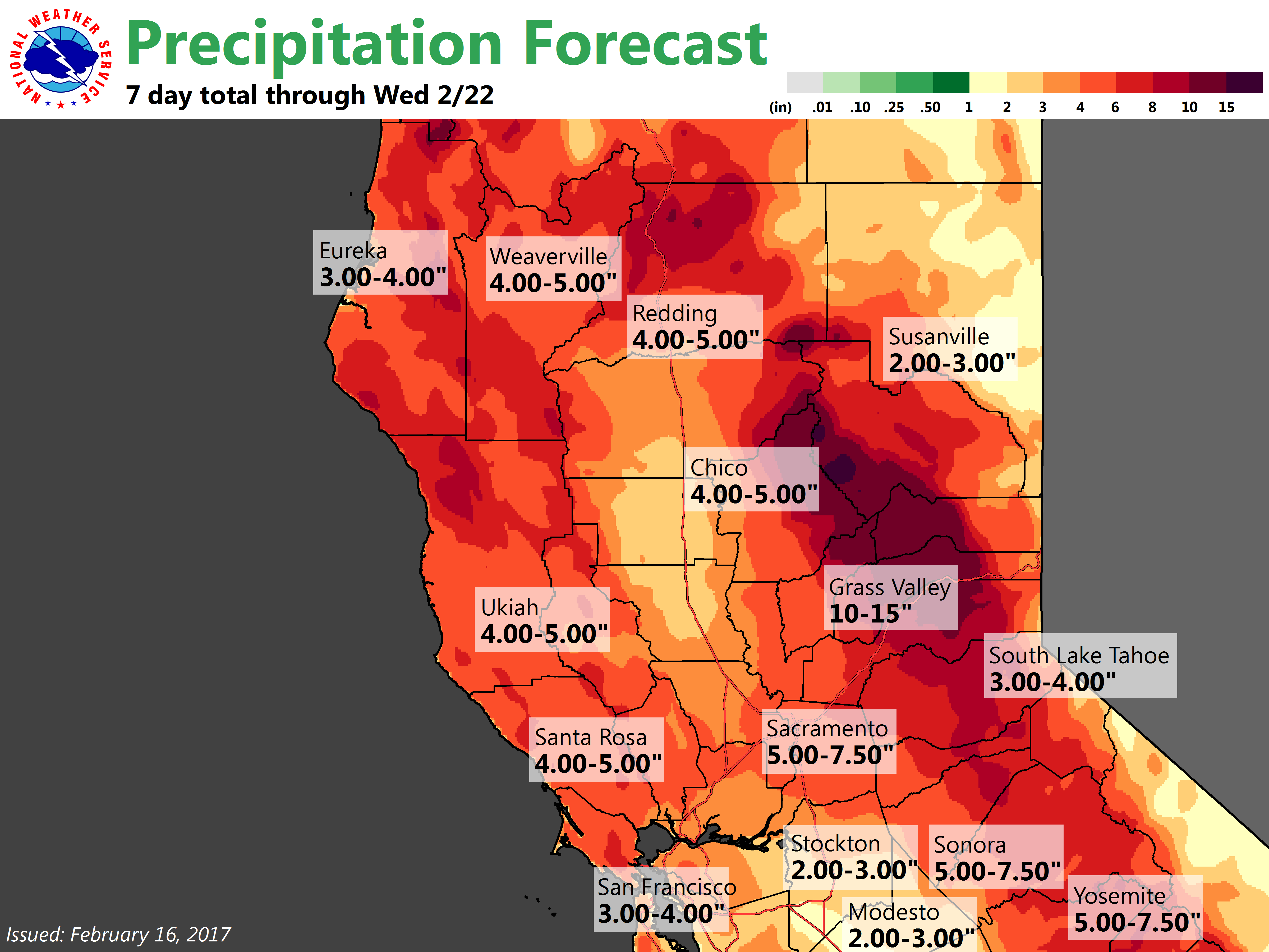
Models continue to trend stronger with the system forecast to move into NorCal Sunday night and Monday as it taps deeper moisture over the eastern Pacific. Both GEFS and recent operational runs of the GFS and ECMWF have been indicating that the deeper moisture is likely to reach further north with an 24-30 hour period of moderate to heavy precipitation possible across much of the region. Unfortunately, the focus of heaviest QPF is lining up on the northern Sierra north of Highway 50 up into the Feather River basin.
Have boosted wind and QPF forecasts for Monday with 1-3 inches of rain possible in the valley and 3-10 inches of rain for the foothills and mountains. Snow levels forecast to briefly climb back into the 6000-8000 foot range as deeper moisture moves up from the southwest, but will return to around 4000-5000 feet by Monday night resulting in heavy snow across the higher elevations. Needless to say, impacts from the increased runoff, wind and heavy snow will be considerable.
Upper trough forecast to move overhead later Tuesday into Wednesday resulting in showers, but lower snow levels and lighter QPF. Potential for a couple days of drier weather late next week.