June 20, 2017 – Extended heat wave continues with widespread highs over 100 degrees and warm nights. Isolated afternoon thunderstorms possible over the mountains into mid-week.
Discussion
Clear skies across interior NorCal early this morning. Current temperatures are running around 3-6 degrees cooler compared to 24 hours ago and generally range from the upper 40s and 50s in the mountain valleys to the 60s and 70s elsewhere except for some lower 80s in warmer portions of the Central Valley.
Delta breeze has made a very modest return with the marine layer now around 1K ft deep. This will help keep valley readings close to Monday’s with Delta perhaps a few degrees cooler.

Very weak trough along with lingering mid/upper level moisture combined with daytime heating over the higher terrain will lead to more isolated late-day thunderstorms over the NorCal mountains today and Wednesday.
High pressure strengthens again Wednesday into Thursday and will suppress the Delta Breeze leading to warmer temperatures. It will also likely limit thunderstorms to the Sierra south of Tahoe. In addition, north winds will set up in the valley, especially on the western side on Wednesday and Thursday. Those winds, coupled with dry conditions will enhance fire weather concerns.
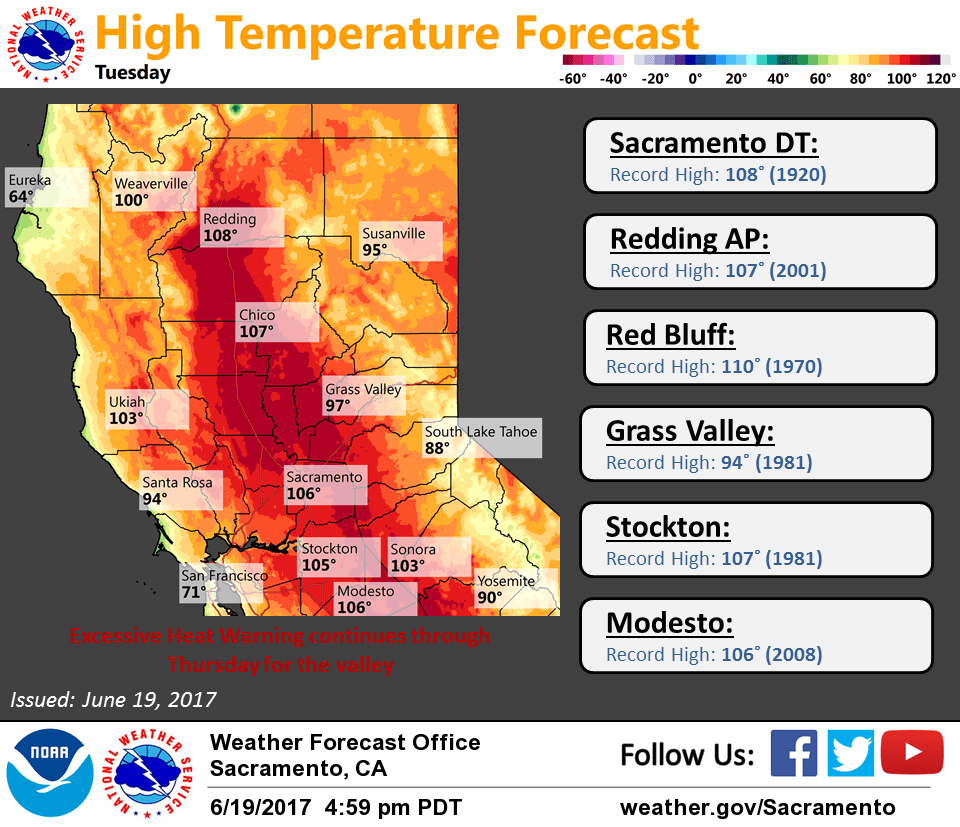
Some record highs are listed below.
Record Highs………..Tuesday….Wednesday..Thursday….Friday
Redding City………..109(1961)..108(1961)..109(1970)..109(1925)
Redding Apt…………107(2001)..110(1992)..107(2006)..111(2006)
Red Bluff…………..110(1970)..110(1962)..111(1970)..112(2006)
Sacramento………….108(1920)..108(1961)..107(1981)..106(1988)
Sacramento Exec……..109(1961)..111(1961)..106(1968)..105(2006)
Stockton……………107(1981)..111(1961)..108(1981)..108(1964)
Modesto…………….106(2008)..109(1973)..106(1954)..107(2006)
Extended discussion (Saturday through Tuesday)
A NW to SE orientated long wave ridge in place over NorCal through the weekend with a weak short wave trough that passes through on Sunday which may bring instability to the area. At the least, temperatures will cool as a Delta breeze looks to develop late this weekend. Monday and Tuesday continue the cooling trend and onshore flow as the longwave ridge shifts into the Great Basin and a longwave trough works its way closer to the coast.