September 6, 2017 – The National Weather Service in Sacramento has issued a Red Flag Warning for abundant lightning, which is in effect from 2 PM this afternoon to 11 PM Thursday. The Fire Weather Watch is no longer in effect.
* THUNDERSTORMS: Scattered to numerous thunderstorms will be possible with some wetting rain, especially for the mountains. Lightning may strike outside of rain cores.
* OUTFLOW WINDS: Gusty, erratic winds are expected near any thunderstorms that develop, perhaps to as strong as 40 mph.
* TIMING: this afternoon through Thursday evening. The most widespread thunderstorms are expected late Wednesday night through Thursday afternoon.
* IMPACTS: any fires that develop from lightning strikes will likely spread rapidly.
Precautionary/Preparedness Actions
A Red Flag Warning for abundant lightning means that frequent lightning may increase fire starts for the warned area. A combination of fire starts from lightning and gusty strong outflow winds in thunderstorms can contribute to extreme fire behavior.
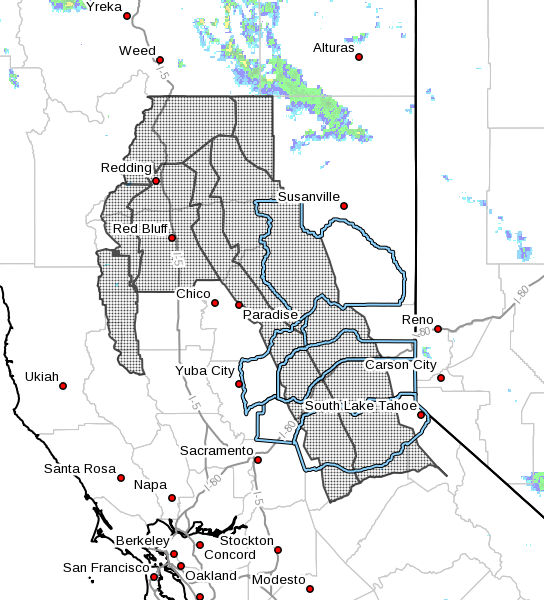
Areas:
Eastern Portion of Shasta/Trinity NF- Burney Basin and Northeast Plateau in Shasta County Including Northwest Lassen NF north of Lassen NP- Northern Sacramento Valley to Southern Tehama County Line Below 1000 Ft-Southeast Edge Shasta- Trinity NF and Western Portions of Tehama-Glenn Unit- Northern Sierra Foothills from 1000 to 3000 Ft. Includes portions of Shasta-Trinity and Butte Units- Northern Motherlode From 1000 to 3000 Ft. Includes portions of Nevada-Yuba-Placer-Amador and ElDorado Units- Northern Sierra Including Lassen NP and Plumas and Lassen NF/S West of the Sierra Crest (West of Evans Peak-Grizzly Peak- Beckworth Peak)- Northern Sierra Including the Tahoe and ElDorado NF/S West of the Sierra Crest-Eastern Mendocino NF