August 23, 2020 – Smoke and haze from wildfires likely to continue to impact air quality and temperatures over interior Northern California for the next several days. Dry thunderstorms possible today into early Tuesday. Near to slightly above normal high temperatures into midweek.

Discussion
Interior Northern California remains sandwiched between upper troughing in the EPAC and upper high over the Desert SW. Offshore residual subtropical moisture is being drawn into the CWA under SWly flow aloft. Lifting mechanism is lacking attm and thus expect mainly some mid to upper level clouds today. Some increase in 700-500 MB MU CAPE suggested by the NAM-12 over the Coastal mountains, Northern Sac Valley, and Sierra Nevada this afternoon for a slight chance of showers and thunderstorms. Haze and smoke from wildfires will continue to impact air quality and temperatures today across portions of CWA. In general forecast highs expected to be up a few degrees over Saturday.
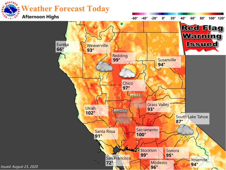
Models depict numerous vort maxes lifting northward across the CWA tonight into Monday. Bulk of disturbances move through after 06z Monday through early Tuesday morning. Isolated high based thunderstorms will be possible with little to no precipitation and gusty wind. Elevated threat of new fire starts exists and Red Flag remains in place to address this. Increased cloudiness and minor drop in 850 mb temps suggest highs Monday will be down a few degrees for most locations. However, fire fighting efforts and resultant smoke amounts could also factor into observed max temps.
Drier mid level air depicted by models moving over interior NorCal on Tuesday should end the threat of showers and thunderstorms. Heights/thicknesses gradually trend down Tuesday into Wednesday as upper troughing in the EPAC progresses towards CA. Near to slightly above normal high temperatures expected by Wednesday.
Extended Discussion (Thursday through Sunday)
Dry weather with above normal temps forecast to continue over Norcal for the remainder of the week. However, the weak but persistent Ern Pac trof will keep the 5H heights of the 4-Corners High suppressed enough over Norcal through the end of the week to keep Norcal from attaining record maxes. Still a strong enough influence of the 4-Corners High for max temps to average some 3 to 9 degrees above normal. The north end of the Valley should reach and slightly exceed triple digits with the warmest day on Fri, and a 79% percent chance equaling/exceeding 100 degrees at RDD, and 32% percent at DTS.
There is increasing likelihood of a cooling trend on Sun and into early next week for Norcal. There are less differences in the deterministic modeling regarding the synoptic pattern in the handling of the the deep low coming out of Russia and AK as it moves into Wrn Canada next weekend, and carving out a deep trof over the Wrn States early next week. The GFS 5H Height/anomaly prog forecasts the srn portion of this trof to move through Norcal early next week. This should begin a cooling trend over Norcal on Sun and into early next week with temps trending closer to normal next Mon/Tue. Breezy winds may accompany the cooling trend especially over the Nrn mtns/Sierra. This will likely be a short-lived cooling trend as the GFS 5H height/anomaly prog forecasts strong ridging to build along the W Coast of NOAM in the wake of the departing low/trof.