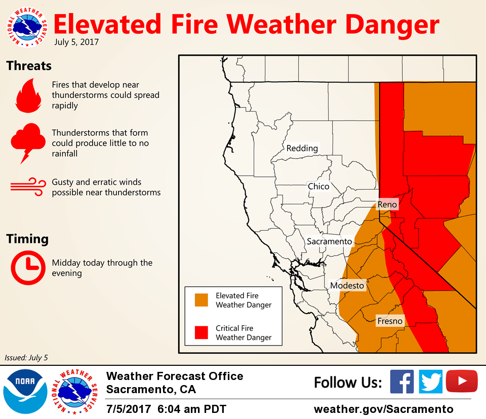
July 5, 2017 – Slight chance for t-storms south of Interstate 80 today, otherwise warm and dry.
Discussion
Mostly clear skies across interior NorCal early this morning, however, some mid and high clouds are beginning to move up from the south. Current temperatures in the Central Valley are running a little cooler compared to 24 hours ago as the Delta Breeze continues and range from the mid 50s to lower 60s in the Delta and Sacramento region to the mid 60s and lower 70s across the remainder of the Valley. Elsewhere, readings are pretty similar to 24 hours ago and generally range from the 40s and 50s in the mountain valleys to the 60s and lower 70s elsewhere.
Satellite imagery shows upper level moisture moving up from the south. A few thunderstorms are indicated off the central California coast, and this area of instability will move northward in the southeastern portion of the forecast area by this afternoon. A fair amount of elevated CAPE is evident on forecast soundings across the northern San Joaquin Valley and Motherlode with moisture mostly concentrated above 500 mb, so a few high- based thunderstorms with little rain cannot be ruled out as a weak short-wave provides just enough lift to get things going.
Otherwise, warm and dry weather will continue today across interior NorCal. Just enough onshore flow continues to help moderate temperatures through most of the Valley.
A return to hotter weather is expected to begin Thursday and continue into the weekend as the Southwest high builds westward bringing as slightly warmer airmass and compressing the marine layer. Most of the Sacramento and northern San Joaquin Valleys will be above the century mark Friday and Saturday.
Extended discussion (Sunday trough Wednesday)
Expansive ridge of high pressure centered over the Four Corners region will remain to be the predominant weather feature through the extended period. Northern California will be on the western fringe of this ridge, and high temperatures are expected to be several degrees above normal as a result. Portions of the Central Valley are likely to reach triple-digit heat during this timeframe, particularly Saturday through Monday.
The desert monsoon is also likely to be active through the extended period. With S to SW flow over NorCal, thunderstorm activity will tend to favor areas east of the Sierra crest. Can’t rule out a few thunderstorms in our CWA (mainly along the Sierra south of Lake Tahoe).