October 11, 2016 – Temperatures dropping below normal today with a cooling trend continuing this week. A series of Pacific weather systems are forecast to bring precipitation chances late Thursday through early next week.
Discussion
Upper level ridging will bring dry conditions over the next couple of days with mainly fair skies. Temperatures will be on a slow decline however as the overall airmass cools slowly dropping to a little below normal today with a little more cooling on Wednesday.
The Delta and near delta areas will see a bigger drop in temperatures today thanks to an increased delta flow. Winds at Travis AFB today should hang in at around 20 mph through much of the day. The marine layer has deepened considerably over the last 24 hours and some coastal stratus is likely in the delta this morning.
The upper level ridge begins shifting eastward on Thursday as a Pacific frontal system approaches the coast. High clouds will be moving in as early as Wednesday afternoon with skies becoming mostly cloudy by mid day Thursday.
Areas north of interstate 80 will see a threat of showers by afternoon with all areas seeing daytime highs 10 or more degrees below normal. The main frontal band appears to move through the north state Thursday night or early Friday with a good chance of precipitation most of the CWA.
Snow levels should remain mainly above pass levels so should not be a major travel issue at least through the short term period.
Breezy conditions and precipitation Friday will be a significant change of pace however from the current mild weather pattern. Would not be surprised to see a few isolated thunderstorms late Friday behind the main front but have left them out for now in hopes of getting better timing.
Extended discussion (Saturday Through Tuesday)
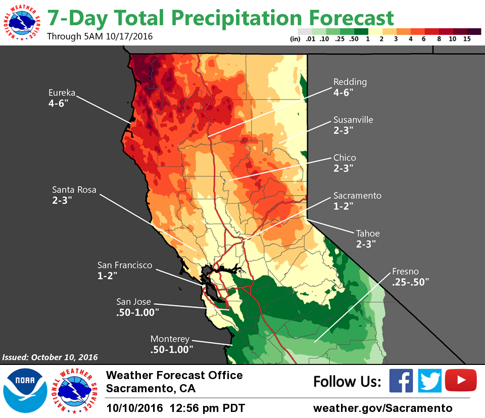
Series of moist Pacific frontal systems will move through Interior Norcal over the weekend as atmospheric river is focused over the CWA. Post frontal showers expected over the area Saturday mainly in the north and over the mountains.
Secondary wave then moves through Saturday night into Sunday bringing additional widespread precipitation. Precipitation decreases Sunday night into Monday as weak ridging develops.
Another short wave trough brings a threat of precip over the mountains and northern portions Tuesday.
Additional QPF amounts from Saturday through Monday look to be range from about 0.2 to near 2 inches in the Central Valley, greatest in the Northern Sacramento Valley, with 2 to 4 inches in the foothills and mountains.
Snow levels will generally be above 7500 feet through the weekend, lowering on Monday as precipitation is winding down. Periods of breezy to windy conditions can be expected through the weekend with high temperatures 10 to 20 degrees below normal.