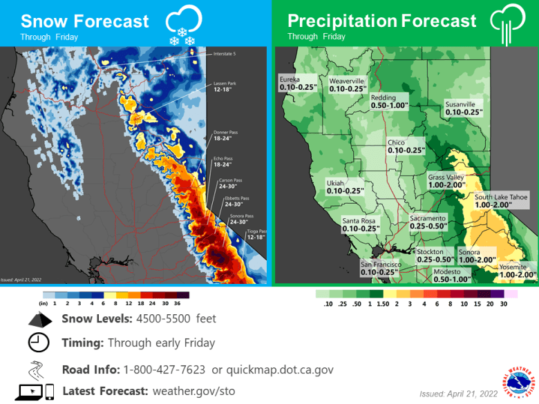
Widespread rain, heavy mountain snow and periods of gusty winds today through Friday. Drier and milder conditions return this weekend and continue through next week.

Discussion
The trough continues to deepen over the region this morning with an isolated thunderstorm already occurred north of Redding. Later this morning greater portions of the Sacramento valley and adjacent mountains north of the Sacramento region may start to see some isolated thunderstorms.

During the afternoon is when the greatest threat over the entire region for thunderstorms will occur and some scattered thunderstorms will be possible. Profiles still look like they would produce heavy rain and small hail. The one earlier did produce some heavy rain with around a third of an inch.
Nice wind shear to the profiles as well over most of the Sacramento valley (best central and north) so it could be an interesting day with some funnel clouds or a weak tornado. The activity should continue into the evening hours before dissipating. Localized flooding will be possible with some of these storms today.

By Friday morning the central part of the trough moves over Nevada with the back end of the trough still over the region. Showers are expected to continue but should gradually taper during the day ending in the evening.
Best chances continue to look to be over the eastern side of the valley and adjacent foothills and mountains. This system continues to look like a very good late season precipitation event for the region with at least 1 to 2 feet of snow over the higher elevations, a half inch to an inch and a half of rain in the valley and 1 to 3 plus inches for the foothills and mountains. Thunderstorms may end up producing locally higher amounts.

Saturday a ridge of high pressure will be building over the region and will warm temperatures back to near seasonal normals with mid 70s expected for the valley and mainly 50s in the mountains. Continued warming is expected on Sunday with highs warming mostly in the lower 80s.
Extended Discussion (Monday through Thursday)
Temperatures will warm into the upper 70s to lower 80s in the valley to mainly the 60s for the mountain valleys on Monday. The ridge will begin to flatten out as a trough begins to move into the Pacific Northwest. By Tuesday a weak dry trough will be over California with some slight cooling each day for Tuesday and Wednesday and valley temperatures cooling back into the 70s. The far northern part of the state including the north end of the valley may have a chance to see a little bit of precipitation from the tail end of that trough but at this point it will most likely remain dry and breezy for both days. A deeper trough will move over the region next Thursday but at this point conditions look to continue to be dry.
