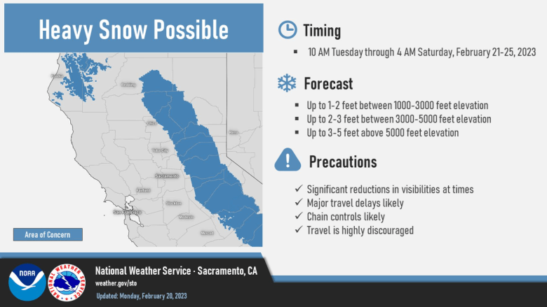
Dry today then colder unsettled weather expected Tuesday into Saturday with the potential for significant snow in the foothills and mountains. Wind Advisory from 10 AM to 10 PM PST Tuesday. Winter Storm Watch from Tuesday morning through late Friday night.

Discussion
Upper ridging moves through today with continued dry weather and above normal temperatures. Highs today expected from the upper 60s to mid 70s in the Central Valley. Locally gusty downslope wind will occur in portions of the eastern foothills/mountains this morning. EPAC high retrogrades Tuesday as cold deep long wave troughing sets up along the West Coast.

Much colder air begins to be ushered in Tuesday with highs 5 to 15 degrees lower than Monday. Models showing shower possibilities beginning after 18z Tuesday as cold dynamic vort max drops south into the CWA. Available moisture looks limited with bulk of precip mainly over the northern and eastern foothills/mountains with highest QPF over the Sierra Nevada.

Snow levels begin around 3000 in the north to 5000 feet in the south Tuesday afternoon, lowering into the foothills Tuesday night.

Winds forecast to increase into advisory criteria late Tuesday morning and linger into Tuesday evening in the Central Valley, and through early Wednesday in the Coastal mountains.

Additional vort maxes drop into the long wave Wednesday into Friday. Reinforcing shots of cold air will keep low snow levels with high snow ratios, resulting in potential for significant snow in the foothills and mountains.
Winter storm watch has been issued to address this. Current models suggesting potential for some rain/snow mix in northern and eastern portions of the Central Valley Thursday morning.
Extended Discussion (Friday through Monday)
Ensembles are in good agreement that by early Friday the cold upper low will be just off the coast of Northern California with southerly flow and a chance of showers over the area. This low will drop southward off the Southern California coast by Saturday, with showers gradually diminishing overnight and mainly mountain showers lingering Saturday.
Snow levels over the northern Sacramento Valley could drop to 500 feet or potentially lower early Friday. There is a 25-40% probability of an tenth of an inch or more of snow for the Redding to Red Bluff area, with a 15% to 30% chance of an inch or more, so slippery road conditions are possible there Friday morning.
Foothill locations and the mountains could see several additional inches of snow, highest south of US Highway 50.
A Winter Storm Watch is now in effect through early Saturday morning for the west slope of the northern Sierra, the mountains of western Plumas County and Lassen Park, and the Motherlode and northeast foothills.
Travel conditions could be difficult across an extensive area of foothill and mountain roads, with heavy storm total snow accumulations up to several feet possible over the higher mountains, and several inches to a couple feet in the foothills.
Additional rainfall amounts in the Valley on Friday are currently projected to be around a tenth to a quarter of an inch, though the showery nature of the precipitation makes specific amounts uncertain at this point. Lingering showers Saturday should be relatively light and mainly south of US Highway 50 over the higher elevations.
On Sunday a weak shortwave will move over the region for more chances of precipitation. This is ahead of a potentially stronger system late Sunday into Tuesday, with the unsettled pattern continuing.
