May 26, 2017 – Temperatures level off Friday with near to below normal temperatures. Slow warming trend this weekend into early next week. Isolated afternoon showers or thunderstorms possible over the northern Sierra into early next week.
Discussion
Upper low over the northern Great Basin with upper trough dropping slowly southward across the north state. This trough is bringing a few clouds to the northern CWA but bigger influence is a continued very deep marine layer. Fort Ord profiler is showing a marine layer depth of nearly 4000 feet. Although deeper than 24 hours ago, believe coastal stratus intrusion into the central valley will be more scattered this morning as stratus layer becomes more dispersed.
Although most locations will see similar high temperatures today, delta influenced areas may see a little warming thanks to a weaker delta breeze today. GFS paints a small area of precipitation over the northern Sierra this afternoon as upper trough axis moves through this region so left a slight threat of thunderstorms northern Sierra crest for the afternoon and evening hours even though other models to not have this feature.

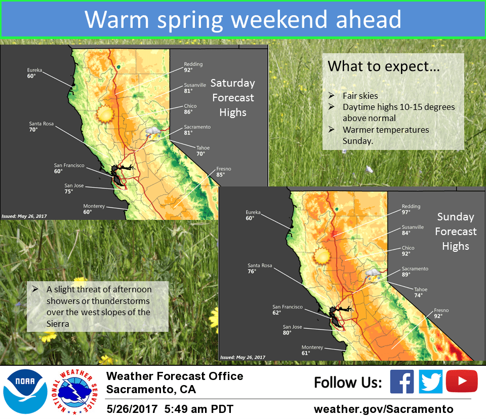
Upper ridge pushes in over the west coast on Saturday bringing the beginning of a warming trend. Marine layer will likely be squashed down significantly so morning marine stratus intrusion will likely be minimal. GFS and NAM both paint light precipitation over the northern Sierra associated with upper trough axis. Upper ridge shifts inland on Sunday bringing a bit more airmass warming.
Daytime highs will reach from a few to several degrees above normal. GFS and ECMWF models add light precipitation to the northern coast range Sunday afternoon as a shortwave ripples northward across the northwest corner of the state. Since timing on this feature could change, will wait for more model runs and consistency before adding any precipitation threat here. Airmass warms a bit more on Monday as upper ridge amplifies over the west. Southerly flow aloft could bring moisture farther up the Sierra so may see a better chance of Sierra thunderstorms going into the early part of next week.
Extended discussion (Tuesday through Friday)
Ridging shifts east on Tuesday in advance of upper level trough approaching the West Coast. One more warm day in store for Tuesday though latest model guidance has actually trended cooler and have nudged max T’s down accordingly. Highs will top out in the upper 90s across the northern Sac Valley, low 90s elsewhere in the Valley and 60s-70s in the mountains. Trough moves into the area on Wednesday and lingers across the region into Thursday. 00z GFS showing more robust system with higher moisture return, painting a chance for showers and thunderstorms across the mountains and possibly even across the Valley. ECMWF features drier solution with little to no precipitation as the trough moves through. For now, have hedged toward a blend with slight chance POPs across the mountains. Regardless of precipitation chances, cooler temperatures will return for Wednesday and Thursday with more seasonable highs. Delta Breeze should be kicking again as well.