July 26, 2017 – Near normal temperatures today, then hot weather returns Thursday into early next week. A slight chance of afternoon mountain thunderstorms today, and then again over the weekend.
Discussion
Very slow moving closed upper level low has now pushed inland, hovering over Mendocino County early this morning. Most of the nocturnal activity has remained in Oregon, while mostly clear skies prevail across much of northern California. A healthy marine layer and moderate onshore breeze are helping to cool the usual locations near the Delta.
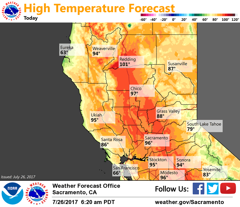
The upper low will slowly drift northeast today, gradually weakening as it does. The best chance of convection today will be near Lassen Park and areas north and east of the park. Otherwise, dry weather will continue across the region. Very warm temperatures are expected this afternoon, with highs reaching the mid 90s to around 102 degrees across the Valley, and 70s to 90s over the mountains.
High pressure over the Desert Southwest will expand toward NorCal Thursday and into the weekend, bringing mainly dry weather and a return to hot temperatures. Triple digit heat is likely across the Valley during this timeframe. Another surge of monsoonal moisture and associated thunderstorms will be possible over the mountains, especially toward the weekend.
Extended discussion (Sunday through Wednesday)
Light upper flow over the region Sunday under large high pressure system over the western U.S. Forecast daytime highs are expected to come in several degrees above normal. With very light upper flow it is difficult to gauge amount of monsoon moisture that will make it into the area. GFS paints afternoon convective precip over the northern Sierra while ECMWF remains mainly dry. Have slipped in a slight chance of afternoon thunderstorms to cover uncertainty.
Very little change expected on Monday so kept temperatures and thunderstorm chance area nearly unchanged. Model confidence fades towards the middle of next week as models differ on handling of upper low pushing in off the Pacific. For now, have kept temperatures and Sierra thunderstorm threat similar to Monday until models come into better alignment.