September 3, 2017 – Excessive heat warning remains in effect until 9 pm this evening. Forecast is showing cooling on Monday (Labor Day). However, highs will still range 92-104 across the valley. Subtle cooling continues with a return to more seasonable temperatures on Wednesday. Smoky & hazy conditions likely to persist for next several days. Potential for fire starts is elevated due to very dry fuels along with thunderstorm potential through Wednesday.
Discussion
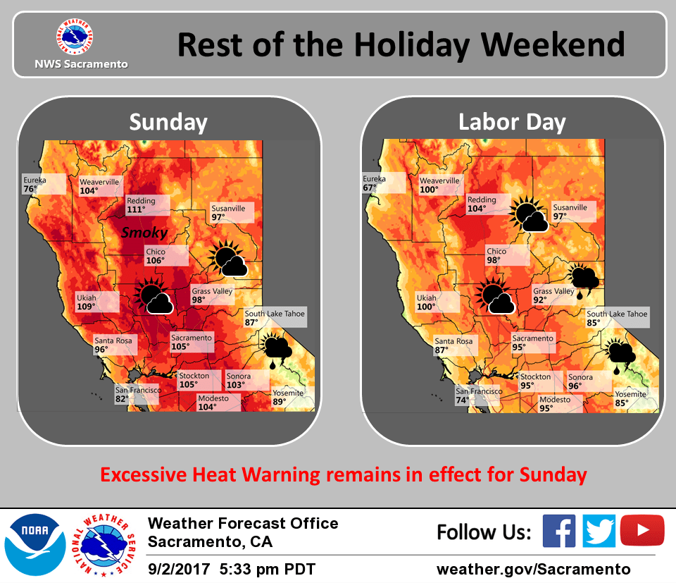
One more day of extreme heat is expected today, with an Excessive Heat Warning continuing into the evening. Temperatures early this morning are even a little warmer than yesterday, generally 1 to 5 degrees higher. At 4 am, Red Bluff, Vacaville, and Blue Canyon were 78 degrees. Oroville was 77 degrees at 4 am, but had been a very warm 89 at 3 am, before easterly downslope winds went calm and allowed temperatures to cool.
High temperatures today will once again been in the triple digits across the area, maybe a few degrees less hot than yesterday. An Excessive Heat Warning continues into this evening. Anyone participating in outdoor activities today should be prepared for the heat and take steps to stay cool.
Upper level low pressure off the coast along with high pressure over the Great Basin will bring monsoonal moisture northward into the area. Mid level clouds associated with this will reduce solar heating to some degree, along with smoke and haze from area wildfires. This moisture and instability over the Sierra will also bring the potential for afternoon/early evening showers and thunderstorms from around I80 southward.
Cooler onshore flow is expected Monday through the week. Temperatures for Labor Day will still be above normal, but with a drop of about 8 to 12 degrees from today will seem much more comfortable. Additional cooling will bring temperatures down to around normal levels by Wednesday.
Elevated monsoonal moisture and instability are forecast to progressively spread a slight chance of thunderstorms further northward through the Sierra and into portions of the northern Coastal Range Monday into Wednesday.
Extended discussion (Thursday through Sunday)
Monsoonal moisture and moisture from tropical storm Lidia will be present over NorCal to start the extended period. This will bring the possibility for late day convection in the mountains. A trough will then drop south out of the Gulf of Alaska late Thursday. The GFS keeps this trough as an open wave but the EC closes it off and lingers of the coast of California. The potential for showers and thunderstorms decreases for Thursday through Saturday with a somewhat drier airmass in place. Cooler temperatures are in store for the extended period, we will see them near normal for mid week and falling 5-10 degrees below normal for a change toward the end of the week.