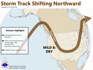
January 23, 2019 – Dry weather with locally breezy northerly winds expected through the week.
Discussion
Satellite imagery continues to show the upper ridge amplifying over the eastern Pacific while a short-wave trough is passing through the PacNW. Some high clouds are spilling over the ridge into NorCal, but overall skies are mainly clear. Current temperatures are milder in the mountains compared to 24 hours ago while lighter winds are resulting in cooler temperatures through much of the Central Valley. Readings range from the teens in the mountain valleys to the mid 30s to mid 40s elsewhere.
Weak disturbances will drop south along the eastern portion of the upper ridge through the week and cause periodic increases in north winds. The breeziest period will be tonight and Thursday and will likely diminish the early morning fog threat much of the week.
Extended Discussion (Sunday through Wednesday)
Ridging will lead to quiet weather for the extended part of the forecast. Warmer than normal temperatures are forecast each afternoon, with highs for the valley making it into the 60s while the upper 40s and low 50s will be observed at higher elevations. Low temperatures will generally be around climatological normals.

