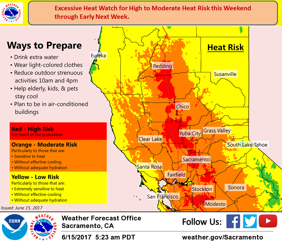
June 15, 2017 – Dry weather with a warming trend for the remainder of the week. Hot temperatures Friday into much of next week with widespread highs over 100 degrees and warm nights in the valley. Prepare for an extended heat event. Isolated thunderstorms possible over the Sierra Sunday through Tuesday.
Discussion
Fair skies over the forecast area this morning under flat high pressure over the southwest U.S. Temperatures warmed several degrees on Wednesday under a warming airmass and this trend has continued into this morning as temperatures this morning are still running a few to several degrees warmer than 24 hours ago.
Upper ridge continues to amplify today over the west coast. Warming today will be tempered slightly as a shortwave trough pushes through the Pacific Northwest. This will bring some high cloudiness to the northern zones but most locations will still see a slight warming today.
More significant warming is expected on Friday as airmass warms more under the ridge. Afternoon highs in the central valley will push up to near 100. More warming on Saturday will spread the heat risk over the CWA significantly.
Most of the central valley will see daily max values over over 100 with the foothills in the 90s. The delta breeze will be of little help as subsidence under the ridge will be all but shut it off.
Still more warming on Sunday pushing daytime highs to near record. Heat advisory conditions over the weekend are likely to continue into early next week so have extended the heat advisory currently in place by a day and this advisory will likely see farther extensions if current forecasts verify. Models have been hinting at sliding some moisture up the Sierra for a threat of afternoon thunderstorms over the Sierra. Will keep this threat in the forecast starting Sunday.
Extended discussion (Monday through Thursday)
Hot weather continues through the extended period, with triple digit heat across the Valley, 90s to near 100 in the foothills, 70s to 80s in the higher elevations. Highs are expected to peak on Tuesday, though temperatures are expected to cool just slightly through Thursday, with heat risk continuing. More significant cooling could arrive by the weekend, though.
Models continue to show the potential for afternoon thunderstorms over the higher Sierra Monday and Tuesday.
Some breezy north winds expected Tuesday and Wednesday. This could bring some heightened fire weather concerns.