
NEVADA CITY, Calif. October 15, 2019 – On Friday, September 20, 2019, reports about high turbidity in the South Yuba River started arriving. Two rain events on Tuesday and Thursday, Sept. 17th and 19th respectively, had brought a little over an inch of rain each to the area – the first “real rain” after a dry summer.
This photo prompted YubaNet’s reporter to drive to the 49’er Bridge between Nevada City and North San Juan.
At that time, the South Yuba river was unrecognizable – no clear water running over the granite boulders, instead a yellowish soup was making its way downstream.

Nevada County’s Environmental Health staff just left the parking lot of the South Yuba River State Park as we rolled up. Also busy taking photos and shooting a short video were SYRCL Executive Director Melinda Booth and River Policy Manager Ashley Overhouse.
SYRCL did take a water sample and indicated they would have tests run immediately.
At 5:00 pm, Nevada County staff held a meeting in the Emergency Operations Center, with State Parks, BLM, local Fire Departments and various county departments.
At the same time, CHP’s Helicopter H20 was in the air, flying the length of the South Yuba, starting downriver near Englebright. The flight ended above Edwards Crossing where the water ran clear. The helicopter took extensive video of a private property. On September 25, an update released by Nevada County stated: “Nevada County officials have identified a property on the 13000 block of Kilham Mine Road in Nevada City as the possible source of Friday’s South Yuba River plume that moved downstream to Englebright Lake… After identifying the property by flying upriver with California Highway Patrol early on, officials from the County, Department of Fish and Wildlife and California State Water Resources Control Board made contact with the property owner on Tuesday. The owner has been cooperative, and staff from Nevada County Environmental Health have taken soil and water samples from the property to help complete the investigation.” [source: Nevada County Yuba River Advisory]
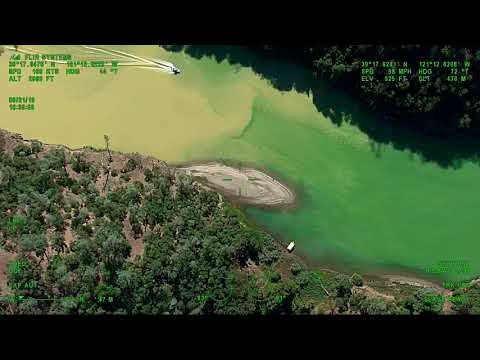
Video of the plume
This excerpt of the Sept. 20th video shows the extent of the plume.
Quick decision to put safety first
Various county departments, the CEO and many of her staff decided to err on the side of caution and issue a No Swim Advisory.
The South Yuba River, from below the Town of Washington to Lake Englebright, currently appears to have high level of sediments of unknown origin suspended in the water creating potentially unsafe river conditions for all people and animals. The cause is under investigation, and due to possibly unsafe swimming and recreation conditions, Nevada County Environmental Health has issued a No Swim Advisory for the South Yuba River below Washington to Englebright Lake.
September 21
The next day, No Swim Advisory placards went up at all river crossings. Later that morning, test results indicated dangerous levels of E.coli, prompting additional warnings. The E.coli and the sediment plume were two separate incidents.
Test results shared with YubaNet indicate a level of 816.4 MPN/100 ml (most probable number of coliform per 100 ml) Maximum Acceptable Concentration for Drinking Water = none detectable per 100 mL

Alas, people did not always heed the advisory.
The No Swim Advisory included swimming, ingesting, bathing and recreational activities. The advisory was extended to include Lake Englebright.
State Parks, SYRCL staff and volunteers assisted Environmental Health, collecting additional water samples for testing in various locations from Humbug Creek on the South Yuba River to Englebright Lake.
Volunteers from that morning’s Yuba River Cleanup helped to post No Swim Advisory signs near common river recreation locations. The Army Corps of Engineers and Skippers Cover Marina also assisted County staff in notifying boaters of the No Swim Advisory on Englebright Lake.

Both soil and water samples were taken at various locations along the river. Heavy metals, a legacy of the county’s mining history are frequently found in sediments.
Meanwhile, the discoloration started to clear up, leaving behind pockets of sediment and a bathtub ring effect along the river’s edge.
September 22
Dissolved metal test results, shared with YubaNet indicated very high levels of iron in the samples taken. 261.3 micro grams were detected near Edwards Crossing.
Taste thresholds of iron in water 0.1 mg/l for ferrous iron and 0.2 mg/l ferric Iron, giving a bitter or an astringent taste. Water used in industrial processes usually contain less than 0.2 mg/l iron. Black or Brown swaps water may contain iron concentration of several mg/l in the presence or the absence of dissolved oxygen, but this iron form has little effect on aquatic life. The current aquatic life standard is 1.0 mg/l based on toxic effects. [source: National Center for Biotechnology Information]
An update provided by Nevada County read, in part: “Recent repeat sampling by Nevada County Environmental Health shows decreasing levels of E.coli at the Highway 49 bridge on the South Yuba River, however the No Swim Advisory remains in place due to unknown sediments that may contain toxic metals or other unhealthy substances.
The color of the plume is not due to the E.coli originally found, and it is unknown if the E.coli is correlated with the plume. If you were in the affected water since Friday and are experiencing vomiting or diarrhea, please contact your primary care physician. Nevada County Public Health has noticed local health providers about the possibility of E.coli associated with Friday’s plume.”
On October 2nd, an update provided reads, in part: “It does not appear that any cannabis cultivation or active mining on the Kilham Road property was the cause at this time,” said Nevada County Community Development Agency Director Sean Powers. “The investigation is complex and will take time.”
Nevada County Code Compliance continues to investigate and work with the property owner on the alleged code violations. The property owner has been compliant and Code Compliance does not currently believe that the alleged violations are connected to the plume.”
Aftermath
The investigation into the event continues. At this time, Nevada County “continues to work closely with the State who is taking the lead on the investigation and provide any support they may need. We have made plans to be onsite during the next rain event to help gather more information and further identify the source of the plume. We are also working with the Water Board’s Storm Water Program to prevent additional runoff on the Kilham Mine property,” according to the County’s Executive Office.
Asked what type of code violations were noted at a property on Kilham Mine Road, Nevada County officials stated: “It is a policy not to release specific code investigations until the investigation is complete, however violations included improper solid waste disposal, and unpermitted structures and grading.”
Next steps appear to include more collaboration with various agencies and organizations. “The County is following the State’s lead as the agency with oversight over water resources. We still question the surrounding property, and thank the Sierra Fund for the extensive research, history and new information they recently published regarding the possible mining related sources from Humbug Creek. SYRCL has also been extremely helpful in quickly notifying both the County and our state partners, as well as contributing information from their own samples.”
Calls to the Regional State Water Quality Control Board were not returned by publication time.

The Sierra Fund’s news release explained why Humbug Creek could be part of the plume event: “The Sierra Fund has been monitoring the discharge from Malakoff Diggins in Humbug Creek since 2011 and has a gage which monitors turbidity continuously in the reach just downstream of where Hiller Tunnel discharges to Humbug Creek. The gage data allows us to measure how much water and how much sediment is released from Malakoff Diggins every year. The relationship between turbidity and total suspended sediments and mercury have been well established for this site. Using this relationship, the amount of sediment and the amount of mercury that was released during the September storm can be calculated.”
State Parks disputes the Sierra Fund’s findings. Superintendent Matt Green told YubaNet in a phone call that their crews went out to Humbug on Friday, Sept. 20 and did not see any unusual discharge or heavy sedimentation. He pointed to the work done by State Parks over decades to preserve the area and mitigate impacts of the mining legacy on the watershed.
We will continue to follow this developing story.
If you would like to see this as an ArcGIS storymap, please click here.