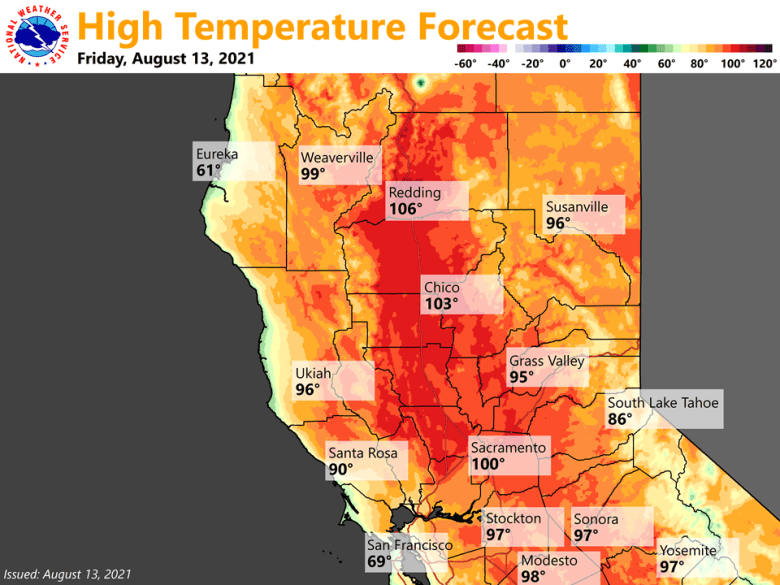
Moderate to locally high heat risk is expected through the weekend. Mostly dry weather forecast except for a chance of isolated mountain thunderstorms through the weekend. Gradual cooling trend expected early next week.

Discussion
Main synoptic setup remains the same with broad high pressure over the Western US with ridge axis just off the West Coast. Satellite imagery is showing high clouds are forming over portions of the Sierra and the Valley early this morning as upper level moisture and a weak impulse moves into the area.
Isolated mountain and foothill thunderstorms lasted into the evening hours yesterday, producing lightning and gusty outflow winds that impacted ongoing wildfires. Isolated thunderstorms are possible again this afternoon and evening as anticyclonic upper level flow continues to push monsoon moisture into the area. Best thunderstorm chances are along the Sierra and southern Cascades with a lesser chance along the Coastal Range. As the ridge axis begins to move east this weekend, thunderstorms become less favorable with an isolated threat over the Sierra crest Saturday and Sunday. The main impacts expected with any thunderstorm are gusty and erratic winds, brief heavy rainfall, and lightning. Any lightning strikes could cause fire starts given extremely dry fuels.

Above normal temperatures will continue to impact Northern California through the weekend. With the ridge axis shifting east over California, temperatures are forecast to rise this weekend. Latest NBM has temperatures increasing a few degrees each day, with Valley highs of 102 to 110 degrees by Sunday. Overnight temperature forecast has also increased with Valley and foothill locations in the low to mid 70s, locally in the low 80s in the thermal belts. This has increased the coverage of high heat risk with locally very high heat risk across portions of the Valley and foothills, mainly on Sunday.
The one caveat to the temperature forecast is the potential for wildfire smoke coverage across the Valley this weekend. Surface winds become more northerly in the overnight and early morning hours near wildfires in Trinity, Siskiyou, and Shasta Counties as well as the Dixie Fire, especially Saturday night into early Sunday. This can push wildfire smoke into Valley, and if daytime onshore flow doesn’t clear the smoke out fast enough, this could dampen temperatures.
Ensemble models show an upper level trough approaching the northern Coast late Sunday into Monday. This will begin to lower heights over Northern California, allowing temperatures to begin lowering with Valley highs in the upper 90s to around 105 degrees.
This could also bring locally breezy winds as the trough passes. Cluster analysis shows timing and depth of the trough remains uncertain, which brings low confidence in strength and timing of winds. Currently forecast is local gusts up to 15 to 20 mph with locally higher gusts in wind prone mountain areas and through the Delta region. However, any winds along with continued dry conditions could bring an increased fire weather risk. Keep an eye out for forecast updates.
Extended Discussion (Tuesday through Friday)
Ensemble guidance indicates the weak trough early in the week will likely shift east by the middle of next week as strong ridging centered over the eastern Pacific edges closer.
Temperatures are forecast to be close to average through Wednesday, then another warming trend will bring above average temperatures for the end of next week.
