Less smoke today with continued dry weather. A gradual warming trend will lead to moderate heat risk later in the week. A cooling trend for the weekend.
Discussion
Smoke will impact the region less today and where there will be smoke expect continued improvement this afternoon and tonight. Have indicated slight warming over yesterdays highs for most areas which puts temperatures at around 5 degrees above seasonal normals for today.

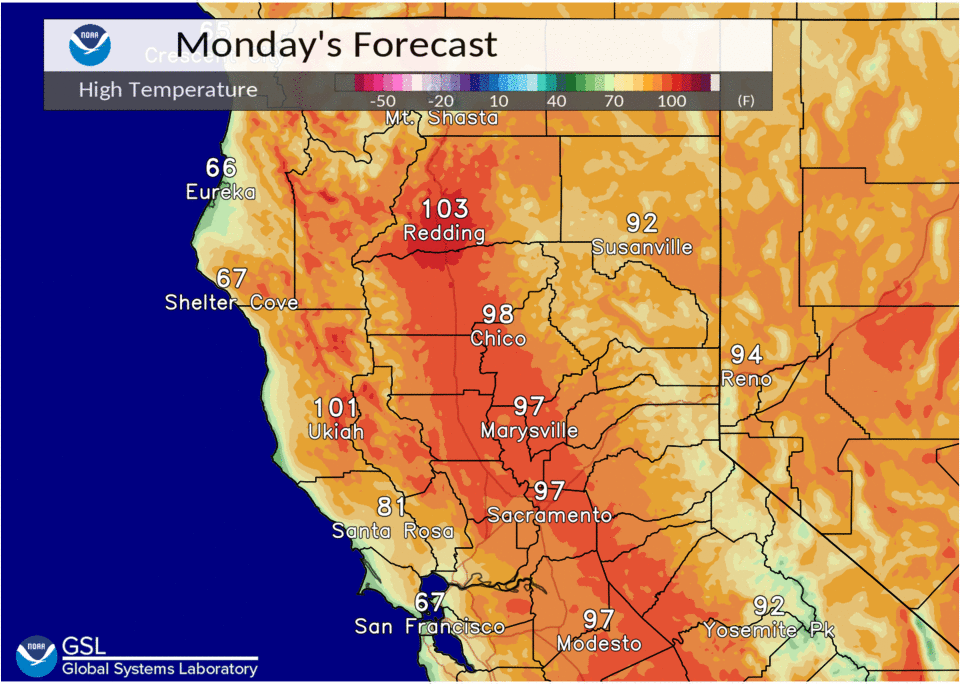
A ridge of high pressure will continue to build over the west coast heating temperatures up each day with temperatures mainly becoming 100 plus throughout the central valley by Tuesday and approaching 110 degrees over the north end of the valley on Tuesday as well. Continued hot inland on Wednesday and Thursday. Daily changes to the Delta Breeze should mainly keep the Sacramento region in the upper 90s to 105 degree range during this period.
Monsoonal moisture moving up from the south will bring some shower and thunderstorm chances back to the Sierra Nevada crest for Wednesday and Thursday.
Extended Discussion (Friday through Monday)
Strong high pressure will remain in place on Friday with temperatures continuing to be hot inland. Monsoonal moisture will continue along the crest with continued chances of showers and thunderstorms. By Saturday a trough will deepen over the west to help push the monsoonal moisture to the south and east and start a cooling trend over the weekend.
For next Monday the models are mixed on the upper air pattern but in general expect dry conditions with temperatures a little above normal.