Moderate heat risk is expected through much of this week into the weekend. Mostly dry weather forecast except for a chance of isolated mountain thunderstorms Wednesday through Saturday. Gradual cooling trend expected early next week.
Discussion
Radar imagery is showing weak radar returns moving northeast through Central California into the Monterey Bay area associated with the monsoonal moisture push coming from the Desert SW. CAMs show these weak returns with virtually no rainfall could continue through the early morning hours but should stay west of our forecast area. At most, cloud cover will increase over interior Northern California through the early morning hours. Instability will increase by late morning as the moisture continues moving northeast into northern California.

Thunderstorm chances increase in coverage today and tomorrow across the mountains with isolated thunderstorms possible in the Coastal Range, Shasta County mountains, and Sierra Nevada.
Thunderstorm chances on Saturday shift back to only the Sierra crest and east. The main impacts expected with any thunderstorm are gusty and erratic winds, brief heavy rainfall, and lightning. Any lightning strikes could cause fire starts given extremely dry fuels. Those who have outdoor mountain plans should be weather aware.
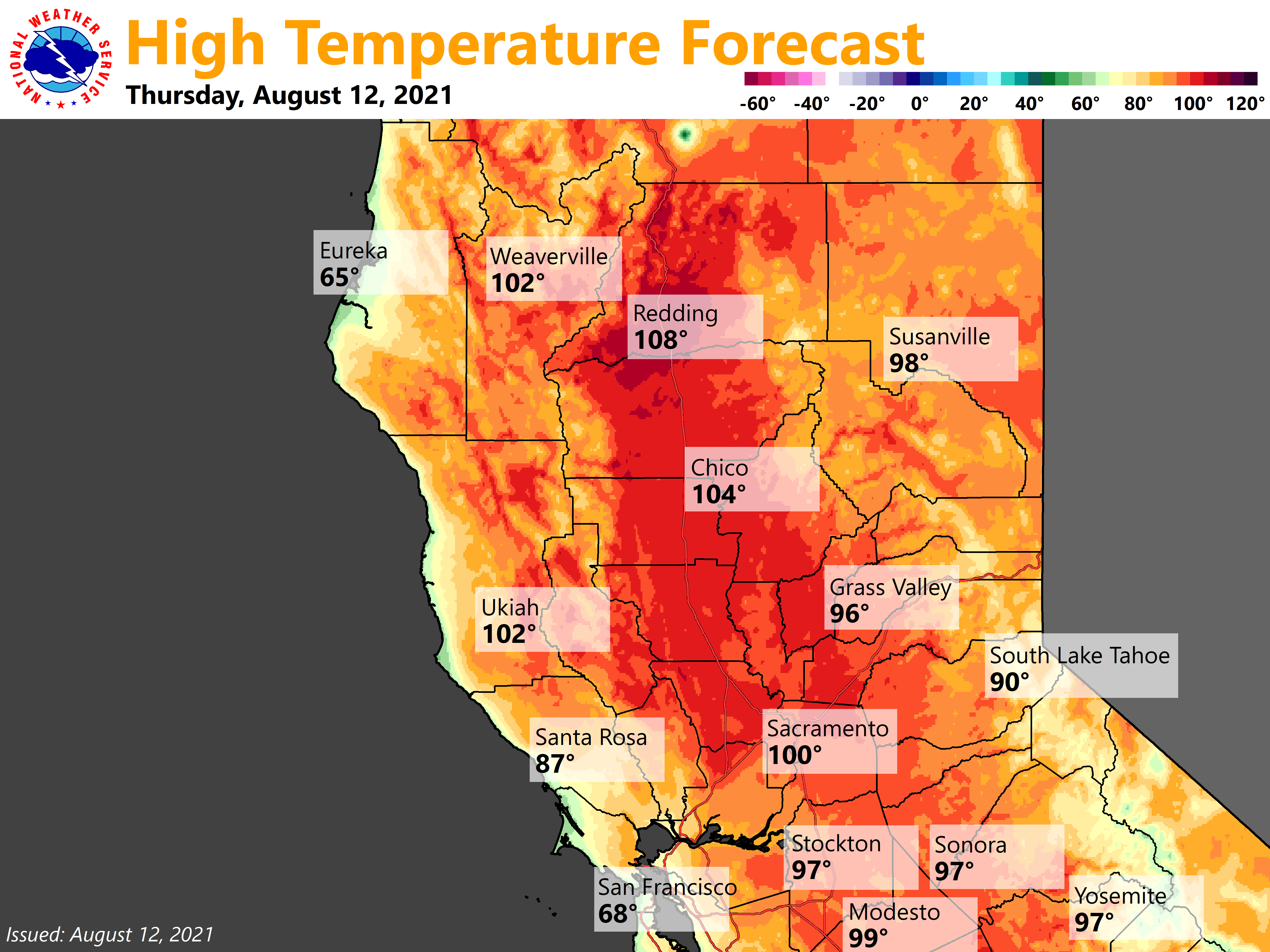
High pressure axis remains over the West Coast through Friday, slowly shifting east to the Intermountain West through the weekend. Therefore, hot and mostly dry conditions will continue through Sunday for interior Northern California. Valley daytime temperatures will range from the upper 90s for the Sacramento area and south to near 108 degrees for the northern Sacramento Valley with mountain temperatures in the 80s and 90s.
Overnight lows will only fall to the low 70s to upper 70s for most Valley and foothill locations. These daytime temperatures of around 5 to 15 degrees above daily normals combined with the relatively warm lows will result in widespread moderate heat risk with some local areas of high heat risk through Sunday. This could cause heat impacts for those who are sensitive to the heat and those who spend time outdoors.
This weather pattern will also continue to produce onshore flow with locally breezy west to south winds as surface gradients tighten each afternoon and evening. The strongest winds will be through the Delta with gusts up to 25 to 40 mph. Other areas including more inland Delta influenced areas as well as wind prone mountain gaps and canyons could see local gusts of 15 to 20 mph. This plus the continued dry conditions will bring isolated fire weather concerns, such as we’ve been observing for much of the summer. It is always vital to practice fire safety during this time of year.
Extended Discussion (Monday through Thursday)
Ensemble guidance remains in pretty good agreement advertising a modest cool down early next week as a trough develops along the West Coast. Clusters indicate there is some uncertainty in its depth and location with a few members indicating a little more digging. This would affect how much north/northeast wind we would potentially see in its wake impacting area wildfires and smoke movement.
Ridging over the eastern Pacific is then forecast to edge closer after mid-week. Temperatures will be around 5 degrees above average Monday, cooling to around normal through the middle of next week.