January 3, 2017 – Continued wet with higher snow levels later today through Thursday followed by another fairly warm system over the weekend.
Flood Watch from this evening through Thursday morning for Motherlode-Northeast Foothills/Sacramento Valley-West Slope Northern Sierra Nevada-Western Plumas County/Lassen Park.
Winter Storm Warning until 4 AM PST Thursday for Shasta Lake Area / Northern Shasta County-West Slope Northern Sierra Nevada- Western Plumas County/Lassen Park.
Winter Weather Advisory until 4 PM PST this afternoon for Burney Basin / Eastern Shasta County-Motherlode-Northeast Foothills/Sacramento Valley.
Wind Advisory from 4 PM this afternoon to midnight PST tonight for Carquinez Strait and Delta-Central Sacramento Valley- Motherlode-Northern San Joaquin Valley-Southern Sacramento Valley.
Discussion
Very active weather pattern continues for NorCal the next couple of days as systems interact with increasingly deep moisture being drawn northward beneath the quasi-stationary low off the PacNW coast. The pattern is forecast to adjust by Thursday and Friday with the low kicking off to the east allowing short-wave ridging to build in allowing a brief window of drier weather late this week.
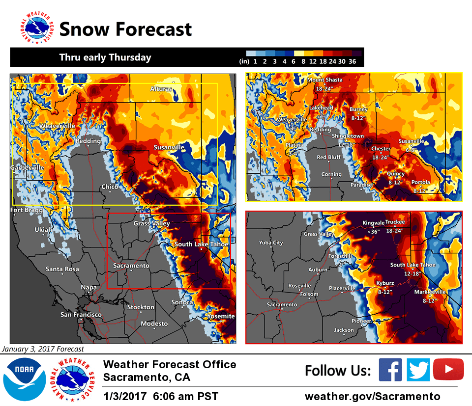
Strong warm-advection develops today and continues into Wednesday. Coupled with good upslope orographic flow, a prolonged period of heavy snow is expected across the west slopes of the northern Sierra Nevada. KBLU forecast soundings show saturation in the -10C to -20C with heavy snow continuing for at least 36 hours. 3 to 4 feet of snowfall accumulation can be expected above 4500 feet with some areas possibly seeing 5 feet or more along the crest by Thursday. Needless to say, severe travel impacts are likely crossing the northern Sierra.
Snow may cut-off a little earlier across the northern mountains as the pattern begins to shift south by Wednesday evening. But increasing travel impacts are likely across I-5 north of Redding later today into early Wednesday before snow levels lift. A foot or more of snowfall accumulation will be possible over northern Shasta County.
Pressure gradients forecast to tighten across the region by this afternoon as the next system approaches. Gusts of 40 to 45 mph will be possibly through much of the Central Valley by this evening and a wind advisory has been posted. Winds will taper off in the valley late tonight.
Rainfall amounts into Thursday look to 1 to 2 inches in the valley, 2 to 4 inches in the northern mountains, and 3 to 7 inches in the foothills and northern Sierra. Significant rises on some area creeks and smaller rivers in the foothills and mountains below the snow line are expected. The usual water issues may crop up within the valley with street flooding of poorly drained areas and mud and rock slides in steep terrain.
Extended discussion (Saturday through Tuesday)
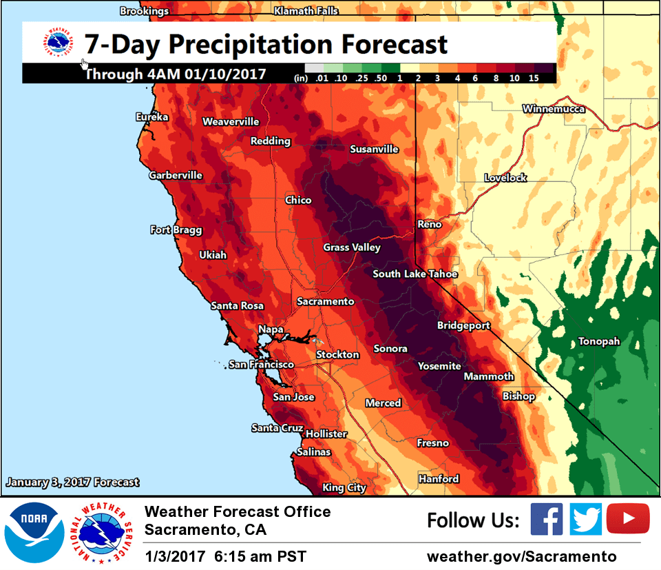
The latest GFS, European, and Canadian model runs are in good agreement for widespread wet weather by early Saturday and continuing through the weekend well into next week.
This begins as the upper level ridge shifts eastward and a deep upper level low from the Gulf of Alaska gradually drifts south and west through the weekend. This taps into a Pacific moisture plume bringing very moist southwest flow, setting up an atmospheric river pattern into northern and central California. Moderate to heavy precipitation is expected, especially over the northern Sierra where strong orographic flow sets up.
Significant snow is possible for the Sierra Saturday with snow levels initially starting between 2000 and 3000 feet. This could cause travel problems during the day. Snow levels are expected to rise above pass levels by Saturday night with strong warm advection.
This storm event is expected to become more of rain event Saturday night, though high peaks will see additional amounts of heavy snow. The heaviest precipitation is currently expected to be around mid day Sunday to early Monday morning. The foothills and mountains could see liquid precipitation totals of 4 inches, potentially up to 7 inches through the weekend. This could bring stream and river rises and possible flooding issues. Additional wet weather is expected through Monday into Tuesday, with models suggesting the wet pattern continuing through the week. Stay tuned for more details as we get closer to this event.