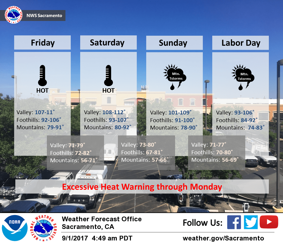
September 1, 2017 – Very hot weather with record highs likely over the Labor Day Holiday weekend. Increasing risk of showers and thunderstorms next week, mainly over the mountains.
Red Flag Warning until 8 AM PDT Saturday for Central Sacramento Valley in Glenn, Colusa, Yuba, Northern Sutter, and Butte County Below 1000 Ft-Eastern Mendocino NF-Eastern Portion of Shasta/Trinity NF-Lake County Portion of Lake-Napa-Sonoma Unit- Northern Sacramento Valley to Southern Tehama County Line Below 1000 Ft-Northern Sierra Foothills from 1000 to 3000 Ft. Includes portions of Shasta-Trinity and Butte Units-Southeast Edge Shasta- Trinity NF and Western Portions of Tehama-Glenn Unit.
Discussion
Very hot and dry weather for interior NorCal today and Saturday as strong high pressure covers the area. Temperatures are milder compared to 24 hours ago and range from the 40s in the mountain valleys to the lower 80s across milder portions of the Central Valley.
Northerly flow is bringing smoke from wildfires down thru much of the Sacramento Valley. This may affect temperatures by several degrees today and Saturday depending on how extensive it gets, but we’re still looking at the peak of this heatwave occurring today and Saturday when much of the Central Valley is expected to top out around the 110 degree mark. Overnight lows will also be very mild with some areas in the thermal belts only dropping into the lower to mid 80s.
Southeasterly flow aloft returns Saturday and increases Sunday as the ridge moves over the interior West allowing monsoon flow to return. Elevated moisture and instability is forecast make it into the Sierra south of Tahoe later Saturday for a slight chance of thunderstorms, then spread further north and west early next week.
Temperatures may edge down a bit beginning Sunday as some mid and high clouds work their way north, and a Delta Breeze may bring a little additional cooling beginning Saturday night.
Extended discussion (Tuesday through Friday)
The strong ridge of high pressure set up over the western US will continue to bring hot weather for the extended period. Highs 92 to 101 are expected which is about 5-10 degrees above normal. Monsoonal moisture will also be in place over the region and that will bring scattered t-storms for the mountains during the afternoons and evenings. Not expecting this activity in the Valley but there will be enough moisture to see scattered clouds. This will help to keep overnight lows warm with them only falling into the upper 60’s to lower 70’s for most. Models want to pull some moisture from tropical storm Lidia into NorCal on Wednesday. This would likely bring our best chance for t-storms.
Models diverge toward the end of the week, the GFS pushes the ridge to the east as a trough drops south out of the Gulf of Alaska. The Euro is slower and further west with the trough allowing the ridge to build back into the region. Currently leaning more with the GFS with the monsoon moisture pushing to the east, limiting our t-storms chances and brining in a slight cooling trend.