Breezy northerly winds today. Unseasonably warm through Friday with record or near record high temperatures. Breezy winds with elevated fire weather concerns return over the weekend. Much cooler temperatures early next week.

Discussion
Strong mid/upper ridge covers the region. and subsidence associated with it is resulting in clear skies. North to east surface pressure gradients have continued to tighten overnight and the MFR to SAC gradient is nearly 9.5 mbs, and the RNO to SAC gradient is nearly 5 mbs.

Northerly gusts of 15-25 mph have spread into the northern Sacramento Valley and down the western edge of the valley, and local northeasterly gusts of 20-30 mph are occurring in the usual windier spots over the northern Sierra Nevada and foothills. The peak gust currently is 46 mph at Jarbo Gap near the mouth of the Feather River Canyon.
Current temperatures across the valley vary widely depending on the wind. Readings range from the mid to upper 40s where winds are light (Vacaville, Travis AFB, Marysville/Yuba City), to the mid 50s to lower 60s at the breezier locales at the north end of the valley and along the west side.

Ridge will build over the region through Thursday with record or near record highs possible across much of the area. Offshore gradients will likely peak this morning before tapering into early Thursday.
Here’s a look at the records the next several days:
Current records for today.
Redding/Redding Airport…..93 in 2016
Red Bluff……………….95 in 1989
Downtown Sacramento………91 in 1989
Sacramento Exec………….90 in 1989
Stockton………………..89 in 2016
Modesto…………………92 in 1989
Current records for Thursday.
Redding/Redding Airport…..94 in 1924
Red Bluff……………….97 in 1989
Downtown Sacramento………91 in 1989
Sacramento Exec………….90 in 1989
Stockton………………..91 in 1989
Modesto…………………94 in 1989
Current records for Friday.
Redding/Redding Airport…..93 in 1989
Red Bluff……………….96 in 1989
Downtown Sacramento………91 in 1989
Sacramento Exec………….90 in 1989
Stockton………………..90 in 1989
Modesto…………………92 in 1989
Ensembles and clusters indicate the likelihood of the ridge flattening over NorCal Friday and Saturday as a trough moves through the PacNW. The combo of synoptic cooling and at least a brief return of onshore flow will lead to minor cooling on Friday with more substantial cooling on Saturday on the backside of the trough with stronger cold advection.
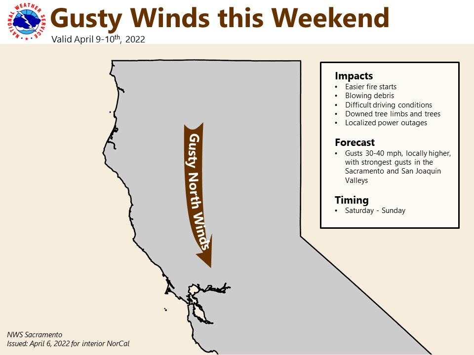
Gusty north winds will also likely return on Saturday with the potential for elevated fire weather conditions.
Extended Discussion (Sunday through Wednesday)
Ensembles give high confidence in a pattern change by Sunday with a significant drop in temperatures as a cold upper level trough from Canada drops southward. The NBM projects Sunday afternoon highs near to slightly above normal levels. Clusters do have quite a bit of uncertainty in the exact depth and track of the trough, though. As a result NBM high temperatures have a larger than normal range of probabilities.
For the Valley this is from the low 60s to near 80. In any case, there will be a big change from the record heat of the previous week. Many of the ECMWF ensemble members project winds gusting to around 40 mph for the Sacramento Valley, so near Wind Advisory levels are possible. Humidity levels could drop to the teens, and these coupled with the winds will bring heightened fire weather concerns.

Grasses are already beginning to cure with the dry conditions and record heat will likely accelerate this. Monday could see some mainly mountain precipitation, though uncertainty in amounts is high. Snow levels could be be low, possibly below 3,000 feet, but current projections of 1 to 3 inches across the mountains suggest minimal impacts at this point. Stay tuned for more details!
Some north winds could continue into Monday and Tuesday, but increased RH levels should diminish fire weather concerns.

An unsettled pattern continues, with near normal high temperatures. Some morning temperatures in the wake of the trough could be quite cool, with the northern Sacramento Valley possibly seeing some 30s.