May 2, 2017 – Dry weather through the middle of the week with temperatures well above average. Cooler weather with showers possible towards the end of the week into the weekend.
Discussion
Other than a few high clouds spilling over the eastern Pacific ridge into NorCal, skies are clear across the region. Current temperatures generally range from the mid 30s to mid 40s in the mountain valleys to the 50s and 60s elsewhere, though the milder spots in the Central Valley and foothills are still hanging onto the lower 70s.
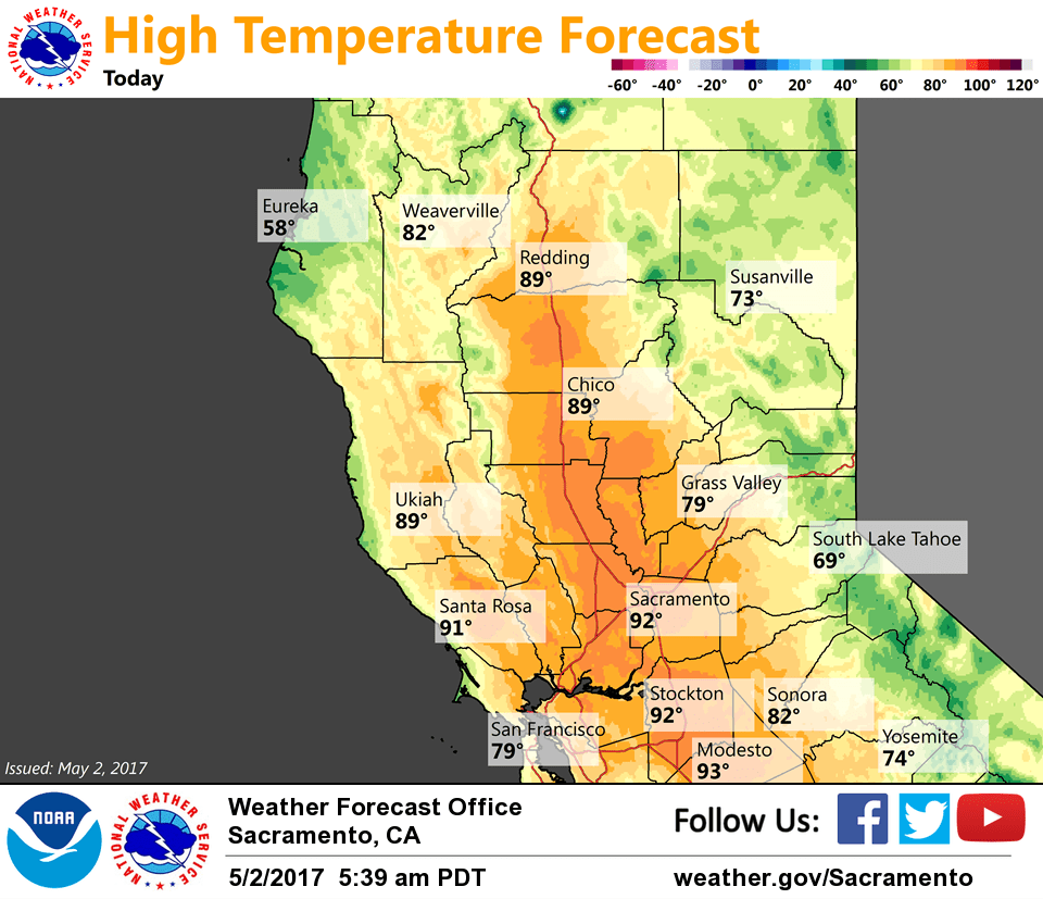
Temperatures will continue to be well above average over the next several days as the strong ridge moves across the area. The airmass continues to warm across the area into mid-week, and it still looks like the warmest day for much of the region will be on Wednesday when the entire Central Valley is expected to top out in the 90s.
Northerly winds will pickup again this morning as stronger winds aloft mix down with daytime heating. Gusts expected to top out around 20-25 mph through much of the Central Valley. Lighter northerly winds expected Wednesday.
Ridge starts to shift east late Wednesday into Thursday. Residual moisture along with weakening of mid-level cap may allow for the development of a few showers and thunderstorms across the mountains as early as late Wednesday, but better chances beginning Thursday.
Significant cool down expected to commence Thursday and continue Friday as airmass cools and onshore flow increases ahead of approaching trough.
Extended discussion (Saturday through Tuesday)
Upper level trough axis moves over interior NorCal Saturday, and continues to bring cooler temperatures and chances for precipitation to the area, especially the higher terrain. Models are in good agreement that the low will continue to deepen and cut off as it moves over the West Coast this weekend, though models disagree on placement of the closed system. This is leading to a large spread in QPF amounts and precipitation location. For now, leaning towards a widespread chance of precipitation with low accumulations in the valley. We maintained a slight chance of thunderstorms Saturday as pattern recognition indicates some instability.
The closed upper low moves into SoCal or southern NV (differences between GFS and EC) with wrap-around precip limited to the Sierra and the northern San Joaquin Valley Monday and Tuesday.