March 27, 2021 – Dry weather and a warming trend is expected through the weekend. A passing system cools temperatures slightly Monday with another round of breezy conditions possible Monday and Tuesday.

Discussion
Upper level ridging will promote dry and above normal conditions across the region this weekend. High temperatures will likely be anywhere from 5 to 15 degrees above normal this afternoon and Sunday.
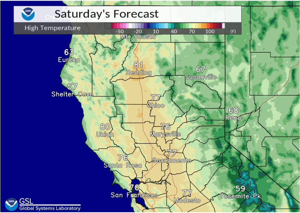
Expect Valley highs to climb into the mid 70s to low 80s, with mid 60s to mid 70s over the foothills. NBM gives Redding Airport an 81% chance of reaching/exceeding 80 degrees, about a 50% chance for the Sacramento area, and about 50 to 70% for the northern San Joaquin Valley.
Cluster 500 mb heights depict a trough tracking through the PacNW late Sunday into Monday. Therefore, maximum temperatures on Monday are forecast to be 5 to 15 degrees cooler than Sunday.
Increased north to east winds are possible Monday into Tuesday as surface pressure gradients tighten behind the trough passage.
Ensemble meteograms suggest wind gusts in the 25 to 35 mph range in the Valley, locally up to 40 mph. Gusts in the 30 to 45 mph range are possible in the mountains and foothills overnight Monday into Tuesday.
Extended discussion (Wednesday through Saturday)
Warm and dry weather with less wind expected the second half of next week as high pressure dominates. Highs across the valley will warm into the lower 80s before cooling somewhat by next weekend as the next trough approaches. A majority of the clusters are slower and weaker with the trough next weekend, so we’ll only introduce a slight chance for precipitation across the far north next Saturday.