
September 25, 2018 – Warming to around 10 degrees above normal by midweek, then cooling Friday into the weekend. Areas of gusty northerly wind today will continue elevated fire weather concern. Slight chance of showers over the Coastal Range and northern portions of the forecast area this weekend.
Red Flag Warning until 5 PM PDT this afternoon for Central Sacramento Valley in Glenn, Colusa, Yuba, Northern Sutter, and Butte County Below 1000 Ft-Eastern Mendocino NF-Eastern Portion of Shasta/Trinity NF-Lake County Portion of Lake-Napa-Sonoma Unit-Northern Motherlode From 1000 to 3000 Ft. Includes portions of Nevada-Yuba-Placer-Amador and ElDorado Units-Northern Sacramento Valley to Southern Tehama County Line Below 1000 Ft- Northern Sierra Foothills from 1000 to 3000 Ft. Includes portions of Shasta-Trinity and Butte Units-Northern Sierra Including Lassen NP and Plumas and Lassen NF/S West of the Sierra Crest (West of Evans Peak-Grizzly Peak-Beckworth Peak)- Northern Sierra Including the Tahoe and ElDorado NF/S West of the Sierra Crest-Southeast Edge Shasta-Trinity NF and Western Portions of Tehama-Glenn Unit-Southern Sacramento Valley in Yolo- Sacramento Far Western Placer, southern Sutter and Solano County Below 1000 Ft-Stanislaus NF West of the Sierra Crest.
Discussion

Upper ridging will continue to build inland across Interior NorCal today into Wednesday resulting in northerly flow aloft and warming AMS. 1033 mb surface high pressure extends from EPAC through the PacNW into the Great Basin. Enhanced low level pressure gradient will continue areas of gusty northerly wind today. Strongest wind expected in northern and western portions of the Sacramento Valley, northeast foothills, western Shasta mountains, and east slopes of the Coastal Range. North wind of around 10 to 15 mph will be typical with local gusts 25 to 35 mph.
High temperatures today are expected to warm another 2 to 5 degrees. Some locally gusty north to northeast will continue to be possible overnight Tuesday into Wednesday morning over Shasta county and eastern foothills and mountains.
Pressure gradient weakens by midday Wednesday. 1000-500mb thicknesses continue to increase tomorrow with a few additional degrees of warming. High temperatures Wednesday forecast to be about 10 degrees above normal.
Potential for some triple digit heat in the Northern Sacramento Valley. Little change in high temperatures expected Thursday, then more significant cooling Friday as deep closed upper low approaches. Marine layer likely to deepen Thursday night into Friday as onshore flow increases. Up to 10 degrees of cooling likely on Friday with highs in the mid 80s to lower 90s for the Central Valley with 60s to lower 80s for the mountains and foothills.
Extended Discussion (Saturday through Tuesday)
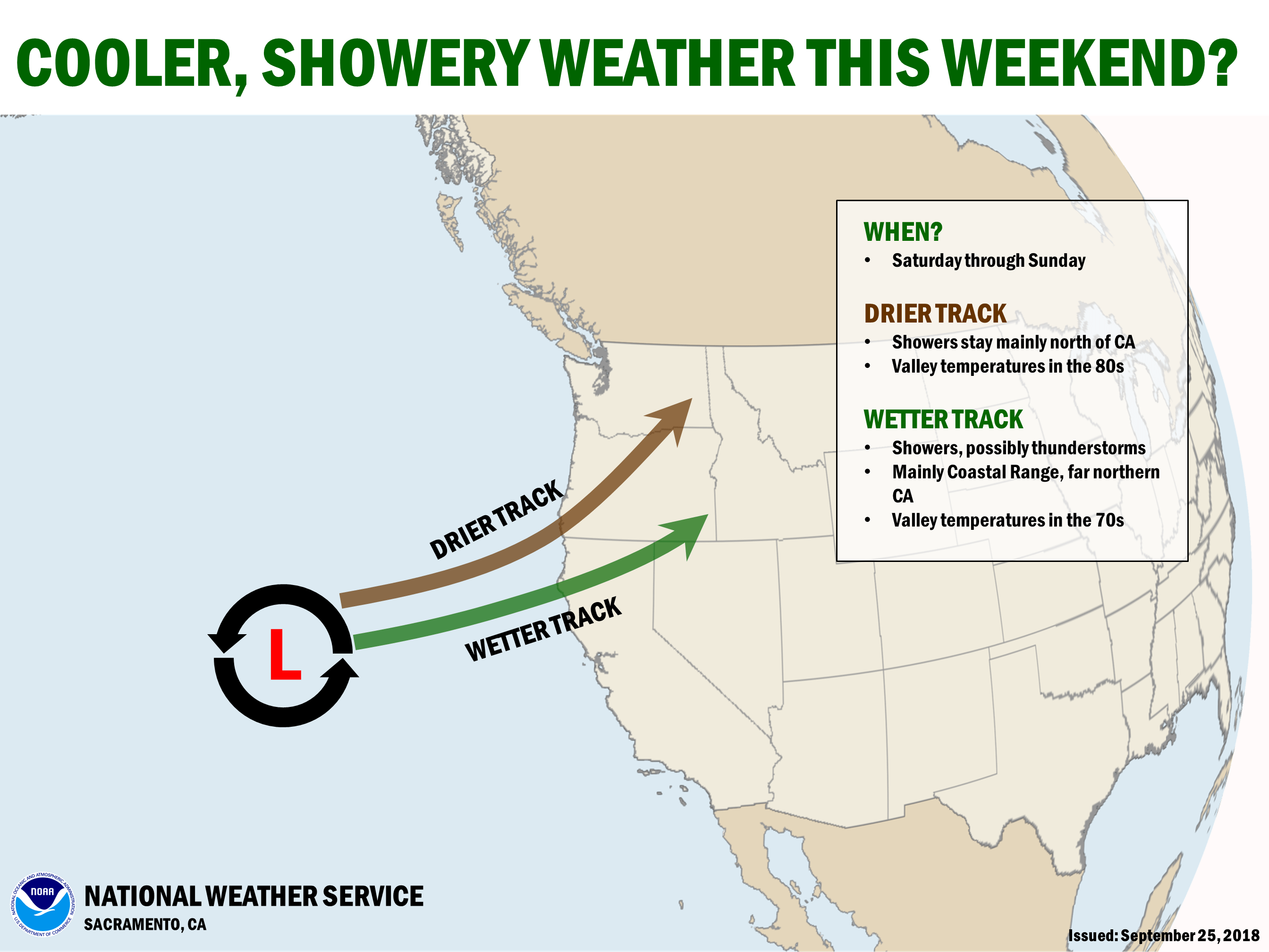
Pacific low portion of the offshore Rex block is forecast to push onto the north coast by Saturday afternoon. This will bring significantly cooler temperatures with daytime highs dropping to between 5 and 10 degrees below normal. GFS and ECMWF both indicating some precipitation associated with this low over the coast range and northern mountains Saturday afternoon and evening. This low opens and shifts to the northeast on Sunday but a few lingering showers may still be possible over the Shasta county mountains.
Models diverge going in to early next week with GFS and ECMWF coming in with two different but interesting outcomes.

ECMWF solution brings a fairly strong for the season Pacific low and frontal system into Northern California on Monday. Precipitation amounts with this scenario would be fairly significant for early October and likely a fire season ending type of event.
GFS has a significantly different outcome taking the Pacific low to the southeast keeping it off the coast. In this scenario, Moisture from a tropical depression now south of Baja is forecast to be pulled northward into southern California on Monday bringing a significant amount of precipitation to the southern half of the state.
For the most part this model solution would leave northern California dry although the southern most CWA could receive some light precipitation. The end of the extended period, next Tuesday looks dry and a little warmer at this time but model confidence is low with such a large variation in model solutions.